 Current Radar (WU)
The Current Radar map shows areas of current precipitation.
Current Radar (WU)The Current Radar map shows areas of current precipitation.
 Current Radar (Intellicast)
The Current Radar map shows areas of current precipitation.
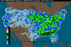
 Radar Summary
The NOWRAD Radar Summary maps are meant to help you track storms more quickly and accurately.
 Yesterdays Radar Loop
Yesterday's Radar Loop shows areas of precipitation for the prior day.
 Forecast Radar
The Forecast Radar map shows where area of precipitation are expected to be in the next 20-30 minutes.
 United States Infrared Satellite
The United States satellite images displayed are infrared (IR) images.
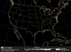 United States Visible Satellite
The visible satellite imagery is essentially a snapshot of what the satellite sees.
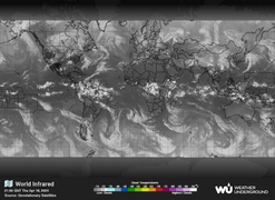 Global Infrared Satellite
The Global Infrared Satellite image shows clouds by their temperature.
 Global Visible Satellite
The visible satellite imagery is essentially a snapshot of what the satellite sees.
 Jet Stream
The Jet Stream map shows today's high wind speed levels and jetstream directions.
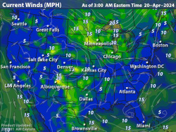 Current WInds
The Current Wind map shows the current wind speed and direction for the most recent hour.
 Today
TodayConvective outlooks are issued for the following three days.
 Tomorrow
Convective outlooks are issued for the following three days.
 Day 3
Day 3Convective outlooks are issued for the following three days.
 United States Current Temperatures
Current temperatures color contoured every 5 degrees F.
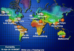 Global Temperatures
Lines of equal temperature in degrees Celsius.
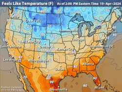 Feels Like Temps
The Feels Like Temperatures map show what the outdoor temperature will feel like for the current day. Feels Like Index is a factored mixture of the Wind Chill Factor and the Heat Index.
 Frost & Freeze Today
The Frost and Freeze map shows where frost cant be expected and where temperature are forecast to fall below 32 degrees F.
 Frost & Freeze Tomorrow
The Frost and Freeze map shows where frost cant be expected and where temperature are forecast to fall below 32 degrees F.
 Daily Precipitation
Precipitation that has accumulated within the last 24 hours.
 Weekly Precipitation
Precipitation that has accumulated within the last 7 days.
 Snow Cover
The snow forecast map shows the forecast snowfall in inches for the current day.
 24hr Snow Forecast
The Storm Track image shows the forecast snowfall over the next 24 hours.
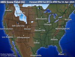 48hr Snow Forecast
WSI's National Image displaying the probabilistic forecast of Light, Moderate or Heavy Snowfall Totals for the next 48 Hours in color contours.
 Atlantic Analysis
The Hurricane Atlantic Analysis image show the current surface features (highs/lows/fronts/tropical cyclones) in the Atlantic Ocean.
 Atlantic Forecast
The Hurricane Atlantic Forecast image shows the 24 hour forecast surface features (highs/lows/fronts/tropical cyclones) in the Atlantic Ocean.
 Pacific Analysis
The Hurricane Pacific Analysis image shows the current and forecast positions of any active tropical cyclones in the central and eastern Pacific Ocean.
 Pacific Forecast
The Hurricane Pacific Forecast image shows the 24 hour forecast surface features (highs/lows/fronts/tropical cyclones) in the Pacific Ocean.
 Current Weather
Composite National Current Weather Map.
 Mixed Surface Analysis
Analysis of current conditions and fronts at ground level.
 12 Hour Surface Forecast
The Surface Analysis map shows current weather conditions.
 24 Hour Surface Forecast
The Surface Analysis map shows current weather conditions.
 36 Hour Surface Forecast
The Surface Analysis map shows current weather conditions.
 48 Hour Surface Forecast
The Surface Analysis map shows current weather conditions.