WunderBlog Archive » Dr. Ricky Rood's Climate Change Blog
Category 6 has moved! See the latest from Dr. Jeff Masters and Bob Henson here.Sea Ice in Hot Water
Sea Ice in Hot Water
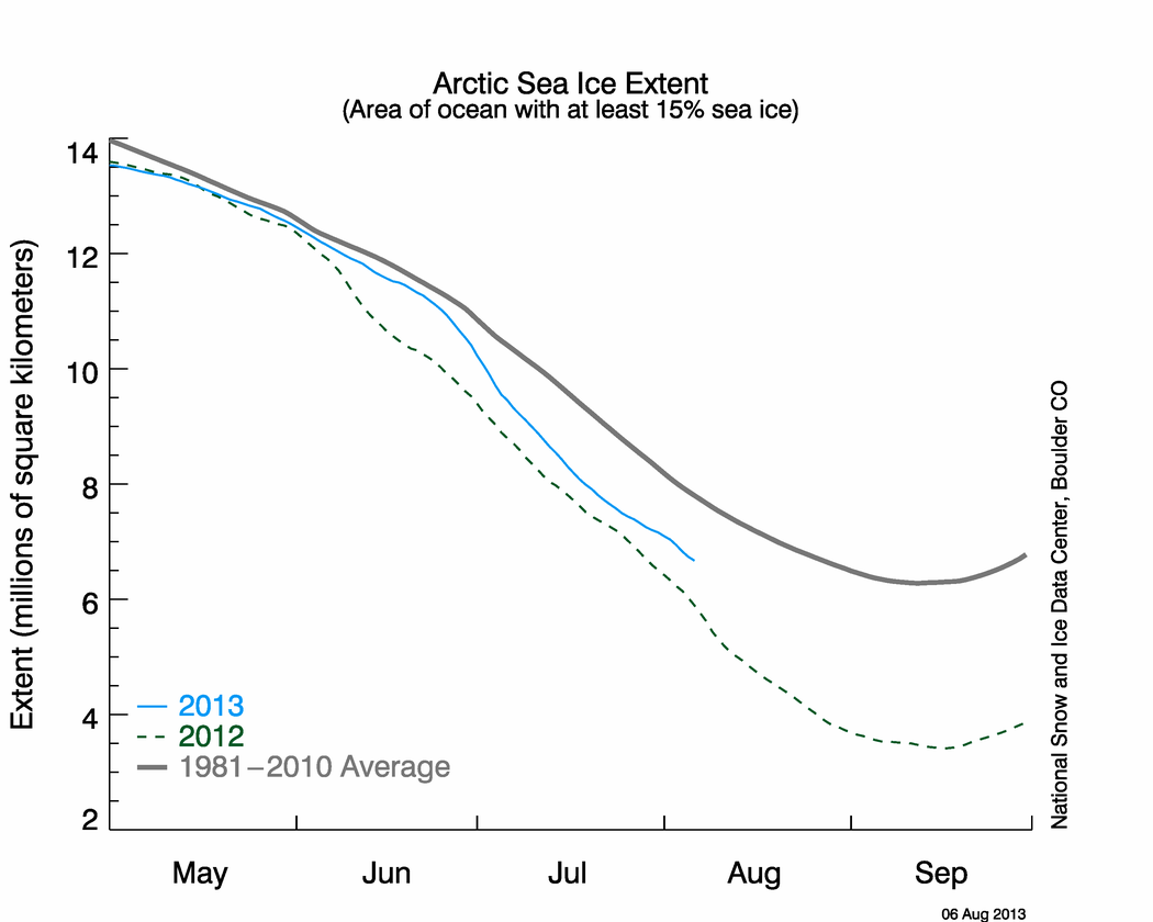
Here is the latest news on the `sea ice area in the Arctic from the National Snow and Ice Data Center. The area of the ocean covered by sea ice is continuing to decrease towards its annual minimum in September. Compared to the rate of decrease observed in late July, the rate of decrease is smaller. A couple of comments to the last blog were about how the ice area actually increased a little after that period of rapid decrease. I will comment on that below, but first here is the current figure.

Arctic Sea Ice Extent from Snow and Ice Data Center Daily Update
OK … Why might the ice area increase in a summer when sea ice is normally melting? How fast the sea ice melts depends not only on how warm the water is, how warm the air is, but also on how the ice is getting stirred by the wind and the ocean current. When the record low of sea ice was recorded in 2007, there was a lot of discussion about the perfect conditions for melting that were present then (Jeff Masters wrote a good blog about this at the time). If you think about ice cubes in a glass of sweet Southern iced tea, if you stir the tea regularly why you are drinking it, the ice will melt far faster than if you just leave the tea sitting. The stirring process allows heat to be carried to the ice.
This is happening all of the time in the atmosphere and ocean; that is, the ice is carried around and it is exposed, in the summertime to melting temperatures. But it takes some time to melt. It is not hard to imagine that ice, either blown by the wind or carried by the currents, can be transported from the main body of the ice pack. This can increase the ice area for a while – until the ice is melted. (It could also be carried to a colder region where it freezes more, but that is not so likely this summer.) The point, there can be modest increases in the area covered by sea ice in the absence of actual freezing to form new ice.
There is a phenomenon called a polynya, which is a stunning example of the impact of dynamics and transport in the sea ice budget. A polynya is a open area, which is largely ice free, surrounded by sea ice. Polynya form in the winter, when the air temperature is plenty cold to freeze water. What happens is that there is an over turning, related to the density of the ice, and warmer, unfrozen water, is revealed from below. Polynya can be very large, plenty big for a submarine to surface.
Getting back to climate change - in late July, the weather was such that the stirring was accelerating ice loss much like 2007. Then that pattern stopped. If it had continued, then the ice loss would likely be huge as the water temperatures are stunningly warm. According to the measurements compiled by the National Climatic Data Center the ocean is the warmest that has ever been recorded. Here is the July plot.
Here is temperature information from the National Climatic Data Center (NCDC) .

Temperatures this high not only lead to sea ice melting, but also to accelerating the outflow of glaciers in Greenland that are in contact with the ocean. These high temperatures come with an El Nino, which contributes to high global temperatures. Many people have pointed out that the previous “hottest” year was 1998, when there was a very strong El Nino. This current El Nino is only moderate in strength and the oceans are showing record temperatures. Sustained high ocean temperatures are consistent with the accumulation of heat at the planet’s surface, because the heat capacity of water is far higher than land, and the ocean doesn’t warm up easily.
These high sea surface temperatures sit in contrast with several cool spots over the northern hemisphere land masses. In fact, in several eastern states, the summer has seen record cool. This temperature pattern is just plain odd, and it will require more analysis. It has been cool in the eastern part of North America, but Washington and Oregon have been very hot. Taking the global average, it has still been a hot summer. If I were to play synoptic meteorologist, I would suspect that a ridge associated with high temperatures in the western half of the continent has displaced the continental distribution towards the east; that is, we are seeing the temperatures typical of central Canada in the eastern part of the U.S. This is a year that will provide some interesting cases studies, and some new insights.
r
This is posted, I hope, from the Frankfurt airport on my way to Goa, India to talk about climate change and public health.
Here is the latest news on the `sea ice area in the Arctic from the National Snow and Ice Data Center. The area of the ocean covered by sea ice is continuing to decrease towards its annual minimum in September. Compared to the rate of decrease observed in late July, the rate of decrease is smaller. A couple of comments to the last blog were about how the ice area actually increased a little after that period of rapid decrease. I will comment on that below, but first here is the current figure.

Arctic Sea Ice Extent from Snow and Ice Data Center Daily Update
OK … Why might the ice area increase in a summer when sea ice is normally melting? How fast the sea ice melts depends not only on how warm the water is, how warm the air is, but also on how the ice is getting stirred by the wind and the ocean current. When the record low of sea ice was recorded in 2007, there was a lot of discussion about the perfect conditions for melting that were present then (Jeff Masters wrote a good blog about this at the time). If you think about ice cubes in a glass of sweet Southern iced tea, if you stir the tea regularly why you are drinking it, the ice will melt far faster than if you just leave the tea sitting. The stirring process allows heat to be carried to the ice.
This is happening all of the time in the atmosphere and ocean; that is, the ice is carried around and it is exposed, in the summertime to melting temperatures. But it takes some time to melt. It is not hard to imagine that ice, either blown by the wind or carried by the currents, can be transported from the main body of the ice pack. This can increase the ice area for a while – until the ice is melted. (It could also be carried to a colder region where it freezes more, but that is not so likely this summer.) The point, there can be modest increases in the area covered by sea ice in the absence of actual freezing to form new ice.
There is a phenomenon called a polynya, which is a stunning example of the impact of dynamics and transport in the sea ice budget. A polynya is a open area, which is largely ice free, surrounded by sea ice. Polynya form in the winter, when the air temperature is plenty cold to freeze water. What happens is that there is an over turning, related to the density of the ice, and warmer, unfrozen water, is revealed from below. Polynya can be very large, plenty big for a submarine to surface.
Getting back to climate change - in late July, the weather was such that the stirring was accelerating ice loss much like 2007. Then that pattern stopped. If it had continued, then the ice loss would likely be huge as the water temperatures are stunningly warm. According to the measurements compiled by the National Climatic Data Center the ocean is the warmest that has ever been recorded. Here is the July plot.
Here is temperature information from the National Climatic Data Center (NCDC) .

Temperatures this high not only lead to sea ice melting, but also to accelerating the outflow of glaciers in Greenland that are in contact with the ocean. These high temperatures come with an El Nino, which contributes to high global temperatures. Many people have pointed out that the previous “hottest” year was 1998, when there was a very strong El Nino. This current El Nino is only moderate in strength and the oceans are showing record temperatures. Sustained high ocean temperatures are consistent with the accumulation of heat at the planet’s surface, because the heat capacity of water is far higher than land, and the ocean doesn’t warm up easily.
These high sea surface temperatures sit in contrast with several cool spots over the northern hemisphere land masses. In fact, in several eastern states, the summer has seen record cool. This temperature pattern is just plain odd, and it will require more analysis. It has been cool in the eastern part of North America, but Washington and Oregon have been very hot. Taking the global average, it has still been a hot summer. If I were to play synoptic meteorologist, I would suspect that a ridge associated with high temperatures in the western half of the continent has displaced the continental distribution towards the east; that is, we are seeing the temperatures typical of central Canada in the eastern part of the U.S. This is a year that will provide some interesting cases studies, and some new insights.
r
This is posted, I hope, from the Frankfurt airport on my way to Goa, India to talk about climate change and public health.
The views of the author are his/her own and do not necessarily represent the position of The Weather Company or its parent, IBM.