WunderBlog Archive » Dr. Ricky Rood's Climate Change Blog
Category 6 has moved! See the latest from Dr. Jeff Masters and Bob Henson here.Cold in a Warm World:
Cold in a Warm World:
I am returning to science in this blog, and ultimately, what I might call a “thinky” problem, thinking about, “how can it be so cold in such a warm world?” We are in the midst of a cold spell that stretches pretty much from coast to coast, north to south, across most of the United States. Of course this has caught the attention of Mr. Limbaugh, who paid wunderground.com a high compliment. (Some have suggested to me that he is not familiar with all of the content on the web site.) First, I want to (re)state something about form of argument. The attribution of a particular warm event or extreme hurricane to global warming is generally not founded in scientific analysis. People, who maintain the argument that global warming is not real, often point this out in their refutations. Similarly, being cold for a while does not stand as proof that global warming is somehow, bogus. If it is your passion to argue that global warming is not real, then it is disingenuous to use the same fallacious form of reasoning as is sometimes used in the attribution of a particular event to global warming. That said - let’s think about how it can be so cold in such a warm world.
As stated in this climate change blog over a year ago, the fundamental role of weather in the climate system is to transport heat from the equator to the pole. This role is complicated by the importance of water and the energy associated with the phase changes of water. Indeed, our notion of climate stability is anchored in the notion of a global-scale balance of the ice, liquid, and gas phases of water. The differential heating between the Equator and the pole drives a circulation to reduce the temperature gradient. The dynamical systems that develop also transport water. The range of temperatures that are common to the atmosphere causes phase changes of water, which in turn significantly impact the spatial and temporal distribution of energy.
Also recall that in the absence of greenhouse gases, especially water and carbon dioxide, the Earth would be much colder; it would be frozen and unpleasant. Hence, one could imagine something like a spring that is “pulling” the temperature down towards this “radiative equilibrium” temperature. The surface warming due to greenhouse gases pulls on this spring.
Just because there is more carbon dioxide and water vapor in the atmosphere does not mean that it does not get cold. The Earth is still tilted on its axis, and the Sun still does not rise on the winter pole. Hence the solar heating is absent in the winter, and the surface and the atmosphere cool down.
Many of the wunderground.com audience are familiar with the idea of “air masses.” Air masses were commonly used to describe the climate and weather, especially, before the 1950s. They remain a useful concept. The basic idea is the following. Large areas of air reside over, for example, continents or the sea, and take on the characteristics of the surface that sits under the air. This leads to large regions of air of similar characteristics. Classic air masses are, for example, tropical maritime which is warm and wet, and continental polar which is cold and dry. Storms, the weather, take place along the boundary of air masses.
If the atmosphere becomes “stuck,” and there is not a lot of mixing between air masses, then the air masses take on extreme conditions. For example, imagine an air mass that forms over Canada in the winter. There is no sunlight; it will get colder and colder. Then when this air mass does get pushed southward, or just grows large enough to extend southward, it will be very cold in places where it generally is not so cold. “Canadian air” will come to the United States. These cold air outbreaks have been around forever, and in the eastern part of the U.S. are often called Alberta clippers
I lived in Tallahassee, Florida in 1976 and 1977, and that was a winter when it was REALLY cold in Southeast. I remember it snowed in Tallahassee and people tried to rake up the snow so they could take pictures. And even better, people who missed the shiny ice on trees put sprinklers in the yard, covered the trees and broke off all of the limbs. We’re just never satisfied are we?
Back to the thinking, it gets us to a couple of questions. What are the reasons that the atmosphere “gets stuck” and air masses take on their most extreme characteristics? That requires a complex answer, and there are still research questions to be addressed. Conceptually, however, we can set up the reasons. If you look at the weather maps of the Northern Hemisphere, in winter and summer you see some “average conditions” that repeat year after year. These are patterns of gigantic highs and lows, like the Aleutian Anticyclone and the Bermuda High. There are two major factors that contribute to average location of these mega-features. These are the contrast of temperature between the land and the ocean and the placement of the mountain ranges. How these mega-features in middle latitudes vary from year to year is the complex part that we don’t completely know. We can find relationships to other mega-features like the El Nino / La Nina cycle. And there are some aspects of the details that might, in fact, be properly described as “chaotic.” But on average, the temperature of the land and the ocean and the mountain ranges set the stage.
There is no doubt of the observation that if the atmosphere gets stuck, a characteristic sometimes known as a “persistent anomaly,” that the air can take on more and more extreme characteristics. (For those who are serious about the weather, look up ideas such as “blocking,” and “cut-off lows.”)
A second question that is begotten in this thinking exercise is, “what is role of climate change?” A warming climate will warm the ocean. The ocean temperature does not vary as much from winter to summer as the land temperature because the ability of the ocean to hold heat, the heat capacity, is much larger. Even in a warming Earth, when the sun goes away for the winter, the land will continue to get very cold. The land’s heat capacity is low compared with the ocean’s. It is reasonable, therefore, to expect that the contrast between land and water, one of the major factors in determining the position of those mega-highs and mega-lows that lead to air masses, will change. As I write this, remember this is a thinking experiment and for better or worse, it is, more or less, a stream of consciousness, it occurs to me that in the Northern Hemisphere the sea ice has changed tremendously in the last 30 years. Reduction of sea ice changes, drastically, the behavior of the surface temperature of the Arctic Ocean. Suddenly I see this isolated North American and Siberian land, cooling its little heart to space after the sun goes down, surrounded by warmer and warmer ocean water. I have not analyzed or researched this problem, but I would expect it to change the behavior of the highs and lows in a very real way.
In my class on climate change I teach that the following are robust: The surface of the Earth will warm, sea level will rise, and weather will change. I don’t say exactly how the weather will change, because it is not easy to quantify, not easy to reduce to a few adjectives, and the answer is not well known. We believe for sound physical reasons that extreme events will get more extreme, persistent patterns of drought and flood will amplify. These changes in extreme events are consistent with persistent anomalies becoming more persistent.
That it has been cold this week in Detroit, Chicago, and Denver gives me comfort that it can still get cold, that the physics of it all holds together, but it gives me no indication what so ever to doubt that the planet is warming. For now, it still has to get cold in the winter.
r
Previous blog on persistent anomaly and drought. This one includes other links.
Dry 'Lanta // SoCal Fires and Climate?
Here is a list of links to basic definitions used in climate.
IPCC Glossary
Arctic Climatology and Meteorology Glossary
Wikipedia Climate Definition
World Meteorological Organizations Climate Theme Page
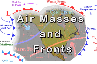
Figure 1: Air mass tutorial from the University of Illinois.
I am returning to science in this blog, and ultimately, what I might call a “thinky” problem, thinking about, “how can it be so cold in such a warm world?” We are in the midst of a cold spell that stretches pretty much from coast to coast, north to south, across most of the United States. Of course this has caught the attention of Mr. Limbaugh, who paid wunderground.com a high compliment. (Some have suggested to me that he is not familiar with all of the content on the web site.) First, I want to (re)state something about form of argument. The attribution of a particular warm event or extreme hurricane to global warming is generally not founded in scientific analysis. People, who maintain the argument that global warming is not real, often point this out in their refutations. Similarly, being cold for a while does not stand as proof that global warming is somehow, bogus. If it is your passion to argue that global warming is not real, then it is disingenuous to use the same fallacious form of reasoning as is sometimes used in the attribution of a particular event to global warming. That said - let’s think about how it can be so cold in such a warm world.
As stated in this climate change blog over a year ago, the fundamental role of weather in the climate system is to transport heat from the equator to the pole. This role is complicated by the importance of water and the energy associated with the phase changes of water. Indeed, our notion of climate stability is anchored in the notion of a global-scale balance of the ice, liquid, and gas phases of water. The differential heating between the Equator and the pole drives a circulation to reduce the temperature gradient. The dynamical systems that develop also transport water. The range of temperatures that are common to the atmosphere causes phase changes of water, which in turn significantly impact the spatial and temporal distribution of energy.
Also recall that in the absence of greenhouse gases, especially water and carbon dioxide, the Earth would be much colder; it would be frozen and unpleasant. Hence, one could imagine something like a spring that is “pulling” the temperature down towards this “radiative equilibrium” temperature. The surface warming due to greenhouse gases pulls on this spring.
Just because there is more carbon dioxide and water vapor in the atmosphere does not mean that it does not get cold. The Earth is still tilted on its axis, and the Sun still does not rise on the winter pole. Hence the solar heating is absent in the winter, and the surface and the atmosphere cool down.
Many of the wunderground.com audience are familiar with the idea of “air masses.” Air masses were commonly used to describe the climate and weather, especially, before the 1950s. They remain a useful concept. The basic idea is the following. Large areas of air reside over, for example, continents or the sea, and take on the characteristics of the surface that sits under the air. This leads to large regions of air of similar characteristics. Classic air masses are, for example, tropical maritime which is warm and wet, and continental polar which is cold and dry. Storms, the weather, take place along the boundary of air masses.
If the atmosphere becomes “stuck,” and there is not a lot of mixing between air masses, then the air masses take on extreme conditions. For example, imagine an air mass that forms over Canada in the winter. There is no sunlight; it will get colder and colder. Then when this air mass does get pushed southward, or just grows large enough to extend southward, it will be very cold in places where it generally is not so cold. “Canadian air” will come to the United States. These cold air outbreaks have been around forever, and in the eastern part of the U.S. are often called Alberta clippers
I lived in Tallahassee, Florida in 1976 and 1977, and that was a winter when it was REALLY cold in Southeast. I remember it snowed in Tallahassee and people tried to rake up the snow so they could take pictures. And even better, people who missed the shiny ice on trees put sprinklers in the yard, covered the trees and broke off all of the limbs. We’re just never satisfied are we?
Back to the thinking, it gets us to a couple of questions. What are the reasons that the atmosphere “gets stuck” and air masses take on their most extreme characteristics? That requires a complex answer, and there are still research questions to be addressed. Conceptually, however, we can set up the reasons. If you look at the weather maps of the Northern Hemisphere, in winter and summer you see some “average conditions” that repeat year after year. These are patterns of gigantic highs and lows, like the Aleutian Anticyclone and the Bermuda High. There are two major factors that contribute to average location of these mega-features. These are the contrast of temperature between the land and the ocean and the placement of the mountain ranges. How these mega-features in middle latitudes vary from year to year is the complex part that we don’t completely know. We can find relationships to other mega-features like the El Nino / La Nina cycle. And there are some aspects of the details that might, in fact, be properly described as “chaotic.” But on average, the temperature of the land and the ocean and the mountain ranges set the stage.
There is no doubt of the observation that if the atmosphere gets stuck, a characteristic sometimes known as a “persistent anomaly,” that the air can take on more and more extreme characteristics. (For those who are serious about the weather, look up ideas such as “blocking,” and “cut-off lows.”)
A second question that is begotten in this thinking exercise is, “what is role of climate change?” A warming climate will warm the ocean. The ocean temperature does not vary as much from winter to summer as the land temperature because the ability of the ocean to hold heat, the heat capacity, is much larger. Even in a warming Earth, when the sun goes away for the winter, the land will continue to get very cold. The land’s heat capacity is low compared with the ocean’s. It is reasonable, therefore, to expect that the contrast between land and water, one of the major factors in determining the position of those mega-highs and mega-lows that lead to air masses, will change. As I write this, remember this is a thinking experiment and for better or worse, it is, more or less, a stream of consciousness, it occurs to me that in the Northern Hemisphere the sea ice has changed tremendously in the last 30 years. Reduction of sea ice changes, drastically, the behavior of the surface temperature of the Arctic Ocean. Suddenly I see this isolated North American and Siberian land, cooling its little heart to space after the sun goes down, surrounded by warmer and warmer ocean water. I have not analyzed or researched this problem, but I would expect it to change the behavior of the highs and lows in a very real way.
In my class on climate change I teach that the following are robust: The surface of the Earth will warm, sea level will rise, and weather will change. I don’t say exactly how the weather will change, because it is not easy to quantify, not easy to reduce to a few adjectives, and the answer is not well known. We believe for sound physical reasons that extreme events will get more extreme, persistent patterns of drought and flood will amplify. These changes in extreme events are consistent with persistent anomalies becoming more persistent.
That it has been cold this week in Detroit, Chicago, and Denver gives me comfort that it can still get cold, that the physics of it all holds together, but it gives me no indication what so ever to doubt that the planet is warming. For now, it still has to get cold in the winter.
r
Previous blog on persistent anomaly and drought. This one includes other links.
Dry 'Lanta // SoCal Fires and Climate?
Here is a list of links to basic definitions used in climate.
IPCC Glossary
Arctic Climatology and Meteorology Glossary
Wikipedia Climate Definition
World Meteorological Organizations Climate Theme Page
Figure 1: Air mass tutorial from the University of Illinois.
The views of the author are his/her own and do not necessarily represent the position of The Weather Company or its parent, IBM.