WunderBlog Archive » Category 6™
Category 6 has moved! See the latest from Dr. Jeff Masters and Bob Henson here.Violent EF-5 Tornado Causes Catastrophic Damage in Moore, Oklahoma
A massive and violent tornado 1.3 miles wide smashed through Moore, Oklahoma near 3 pm CDT Monday, causing catastrophic damage along a 17-mile long path. The National Weather Service in Norman, Oklahoma announced that it has found at least one area of EF-5 damage near Briarwood Elementary School, with winds of 200 - 210 mph. Damage was extreme and covered a huge area, and many buildings swept away down to their foundations. The tornado was on the ground for 51 minutes, from 2:45 - 3:36 pm CDT. This averages out to a 20 mph forward speed, and the tornado was initially moving even slower--20 mph. Violent tornadoes typically move considerably faster, sometimes at speeds in excess of 60 mph, and the relatively slow motion of the Moore tornado contributed to the extreme damage by exposing buildings to a longer period of violent winds than usual. A tornado warning for the storm was issued at 2:40 pm CDT, sixteen minutes before it touched down. On average, a tornado warning comes about thirteen minutes before touchdown. A tornado emergency was declared for Moore at 3:01 pm, about twenty minutes before the tornado entered the west side of the city. The debris ball from the tornado, as seen on Doppler radar, expanded to over two miles in diameter, and debris was carried over 100 miles from Moore. The National Weather Service office in Tulsa, Oklahoma reported at 4:13 pm CDT that they were "seeing reports of light tornado debris falling in the Tulsa metro area again this evening, likely from the Moore area." Tulsa is 100 miles east-northeast of Moore.

Figure 1. The Moore, Oklahoma tornado of May 20, 2013. Image credit: WIkipedia.

Figure 2. A fire burns in the Tower Plaza Addition in Moore, Oklahoma, following a tornado on Monday, May 20, 2013. Photo: Sue Ogrocki, ASSOCIATED PRESS.

Figure 3. Flipped vehicles are piled up outside the heavily damaged Moore Medical Center in Moore, Oklahoma, after a powerful tornado ripped through the area on May 20, 2013. On the enhanced Fujita Scale, the maximum degree of damage (11), indicating EF-5 winds of 210 mph, is "Significant damage to building envelope" on an institutional building like a hospital or government office. The damage to the Moore Medical Center may qualify as EF-5 damage. Image credit: Brett Deering/Getty Images)
Here is the tornado warning that was issued at 2:40 pm CDT, sixteen minutes before the tornado touched down:
BULLETIN - EAS ACTIVATION REQUESTED
TORNADO WARNING
NATIONAL WEATHER SERVICE NORMAN OK
240 PM CDT MON MAY 20 2013
THE NATIONAL WEATHER SERVICE IN NORMAN HAS ISSUED A
* TORNADO WARNING FOR...
NORTHWESTERN MCCLAIN COUNTY IN CENTRAL OKLAHOMA...
SOUTHERN OKLAHOMA COUNTY IN CENTRAL OKLAHOMA...
NORTHEASTERN GRADY COUNTY IN CENTRAL OKLAHOMA...
NORTHERN CLEVELAND COUNTY IN CENTRAL OKLAHOMA...
* UNTIL 315 PM CDT
* AT 238 PM CDT...NATIONAL WEATHER SERVICE METEOROLOGISTS DETECTED A SEVERE THUNDERSTORM CAPABLE OF PRODUCING A TORNADO. THIS DANGEROUS STORM WAS LOCATED NEAR NEWCASTLE...AND MOVING EAST AT 20 MPH.
IN ADDITION TO A TORNADO...LARGE DAMAGING HAIL UP TO GOLF BALL SIZE IS EXPECTED WITH THIS STORM.
* LOCATIONS IMPACTED INCLUDE...NORMAN...MOORE...NEWCASTLE...BRIDGE CREEK AND VALLEY BROOK.
PRECAUTIONARY/PREPAREDNESS ACTIONS...
TAKE COVER NOW IN A STORM SHELTER OR AN INTERIOR ROOM OF A STURDY BUILDING. STAY AWAY FROM DOORS AND WINDOWS.
At 3:01 pm CDT, five minutes after the tornado touched down and about twenty minutes before the tornado hit the west side of Moore, the NWS issued a "Tornado Emergency" advisory:
BULLETIN - EAS ACTIVATION REQUESTED
TORNADO WARNING
NATIONAL WEATHER SERVICE NORMAN OK
301 PM CDT MON MAY 20 2013
THE NATIONAL WEATHER SERVICE IN NORMAN HAS ISSUED A
* TORNADO WARNING FOR...
NORTHWESTERN MCCLAIN COUNTY IN CENTRAL OKLAHOMA...
SOUTHERN OKLAHOMA COUNTY IN CENTRAL OKLAHOMA...
NORTHERN CLEVELAND COUNTY IN CENTRAL OKLAHOMA...
* UNTIL 345 PM CDT
* AT 259 PM CDT...NATIONAL WEATHER SERVICE METEOROLOGISTS AND STORM SPOTTERS WERE TRACKING A LARGE AND EXTREMELY DANGEROUS TORNADO NEAR NEWCASTLE. DOPPLER RADAR SHOWED THIS TORNADO MOVING NORTHEAST AT 20 MPH.
THIS IS A TORNADO EMERGENCY FOR MOORE AND SOUTH OKLAHOMA CITY.
IN ADDITION TO A TORNADO...LARGE DESTRUCTIVE HAIL UP TO TENNIS BALL SIZE IS EXPECTED WITH THIS STORM.
* LOCATIONS IMPACTED INCLUDE...MIDWEST CITY...MOORE...NEWCASTLE...STANLEY DRAPER LAKE...TINKER AIR FORCE BASE AND VALLEY BROOK.
PRECAUTIONARY/PREPAREDNESS ACTIONS...
THIS IS AN EXTREMELY DANGEROUS AND LIFE THREATENING SITUATION. IF YOU CANNOT GET UNDERGROUND GO TO A STORM SHELTER OR AN INTERIOR ROOM OF A STURDY BUILDING NOW.
TAKE COVER NOW IN A STORM SHELTER OR AN INTERIOR ROOM OF A STURDY BUILDING. STAY AWAY FROM DOORS AND WINDOWS.

Figure 4. The annual number of EF-3 and stronger tornadoes, 1954 - 2012. The greatest number of these dangerous tornadoes was 131 in 1974, the year of the notorious "Super Outbreak." The minimum was just 15, set in 1987. The average is 43 per year. Image credit: NOAA.

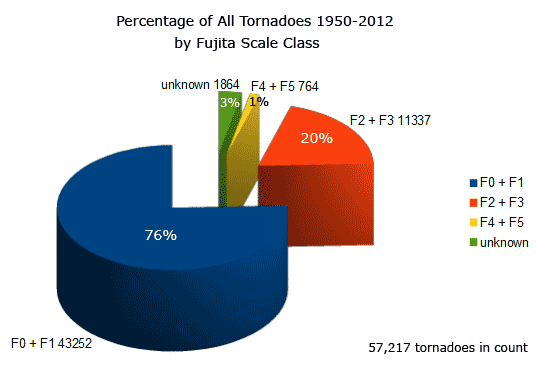
Figure 5. Violent EF-4 and EF-5 tornadoes make up only 1% of all tornadoes, but account for well over half of all deaths. Image credit: tornadoproject.com.
A very bad tornado in an otherwise quiet year for violent tornadoes
According to NOAA, the U.S. has averaged 43 EF-3 or stronger tornadoes per year during the period 1954 - 2012. With tornado season nearly half over, we are well below the average pace for these most dangerous tornadoes--only nine EF-3 and EF-4 tornadoes have been recorded so far in 2013. An average year should have had at least fifteen of these tornadoes by this point in the year. Here are the nine EF-3 and stronger tornadoes so far in 2013:
EF-5, 200 - 210 mph winds, May 20, Moore, Oklahoma. Many deaths and injuries.
EF-4, 166 - 200 mph winds, May 19, Shawnee, Oklahoma. 2 deaths.
EF-4, 180 mph winds, May 15, Granbury, TX. 6 deaths, 24+ injuries.
EF-4, 165 - 185 mph winds, May 18, Rozel, Kansas.
EF-4, 170 mph winds, February 10, Hattiesburg, MS. 0 deaths, 82 injuries,
EF-3, 140 mph winds, May 15, Cleburne, TX. No deaths or injuries.
EF-3, 160 mph winds, January 30, Adairsville, GA. 1 death, 17 injuries, 363 buildings damaged or destroyed.
EF-3, 145 mph winds, April 11, Kemper County, AL. 1 death, 9 injuries.
EF-3, 136 - 165 mph winds, May 19, Luther - Carney, Oklahoma.
Moore tornado likely to be one of the five most damaging tornadoes in history
Moore has the unenviable distinction of having previously experienced the 4th costliest tornado in world history, the notorious May 3, 1999 Bridgecreek-Moore EF-5 tornado. There have been only six billion-dollar (2011 dollars) tornadoes in history:
1) Joplin, Missouri, May 22, 2011, $2.8 billion
2) Topeka, Kansas, June 8, 1966, $1.7 billion
3) Lubbock, Texas, May 11, 19780, $1.5 billion
4) Bridge Creek-Moore, Oklahoma, May 3, 1999, $1.4 billion
5) Xenia, Ohio, April 3, 1974, $1.1 billion
6) Omaha, Nebraska, May 6, 1975, $1 billion
The May 3, 1999 Bridge Creek-Moore tornado killed 36 people and injured 583. It damaged or destroyed 8132 homes, 1041 apartments, 260 businesses, 11 public buildings and seven churches. According to rough estimates of the size of the damaged area made by helicopters operated by news9.com and kfor.com, the damage footprint from the May 20, 2013 tornado is easily twice as large. I expect that after the damage tally from the May 20 tornado is added up, Moore will hold two of the top five spots on the list of most damaging tornadoes in history, and the May 20 tornado may approach the Joplin tornado as the costliest twister of all-time.

Figure 6. Severe weather outlook for Tuesday, May 21, calls for a "Moderate Risk" of severe weather over Northeast Texas, Southwest Arkansas, and small portions of Southeast Oklahoma and Northwest Louisiana. You can follow today's severe weather outbreak from our Severe Weather page.
Here we go again: Another big severe weather day today in the Midwest
The Moore tornado was the first of twenty tornadoes reported on May 20--the third consecutive day with twenty or more tornadoes in the Midwest. Each of these days had a "Moderate Risk" of severe weather, as advised by NOAA's Storm Prediction Center (SPC.) The SPC is calling for a fourth consecutive day with a "Moderate Risk" of severe weather today (Tuesday), with the greatest danger occurring over Northeast Texas, Southwest Arkansas, and small portions of Southeast Oklahoma and Northwest Louisiana. Once again, we can expect to see isolated supercells capable of spawning dangerous violent tornadoes during the late afternoon and early evening hours. The severe weather outbreak moves east and will begin to wind down on Wednesday, when only a "Slight Risk" of severe weather is expected over New York, Ohio, Pennsylvania, plus northern portions of Kentucky, West Virginia, and Maryland.
Video 1. Remarkable time-lapse sequence of the Moore, Oklahoma tornado on May 20, 2013, taken from a news helicopter.
Video 2. Stormchasers caught the dramatic sounds and sights of the Moore, Oklahoma tornado of May 20, 2013 as it moved through the city.
Video 3. Video of the Moore, Oklahoma tornado of May 20, 2013 taken from a smartphone as the tornado moved across an open field.
Jeff Lechus filmed this remarkable video from his car while trying to get to his son. The flying debris near his car was extremely dangerous, and he is lucky he is alive.
Wunderground's weather historian Christopher C. Burt discusses the deadliest tornadoes of all time in his April, 2011 post. Since that post, the Joplin, Missouri tornado of May 22, 2011, killed 158 people, making it the 7th deadliest tornado in history.
My post, 2011: Year of the Tornado from December 2011, detailing the remarkable tornado records set in 2011.
I saved a 10-frame animation of the radar reflectivity image from the Moore tornado here.
I greatly appreciate all the valuable links members of the WU community have posted here, and I have used many of them in my posts over the past day. Keep up the great work!
How to help
Portlight Strategies, an organization that supports disaster victims with disabilities, will be working with shelter operators and disability stakeholder organizations in Oklahoma to serve the needs of people with disabilities. Further information and how to offer additional support can be found on their website.
Donations can be made to American Red Cross disaster relief at redcross.org/weather or by texting WEATHER to 90999 to donate $10.
Donations can be made on The Salvation Army's website or by texting STORM to 80888 to donate $10. You can also call to make donations of other monetary amounts at (800) 725-2769.
Jeff Masters
Figure 1. The Moore, Oklahoma tornado of May 20, 2013. Image credit: WIkipedia.
Figure 2. A fire burns in the Tower Plaza Addition in Moore, Oklahoma, following a tornado on Monday, May 20, 2013. Photo: Sue Ogrocki, ASSOCIATED PRESS.
Figure 3. Flipped vehicles are piled up outside the heavily damaged Moore Medical Center in Moore, Oklahoma, after a powerful tornado ripped through the area on May 20, 2013. On the enhanced Fujita Scale, the maximum degree of damage (11), indicating EF-5 winds of 210 mph, is "Significant damage to building envelope" on an institutional building like a hospital or government office. The damage to the Moore Medical Center may qualify as EF-5 damage. Image credit: Brett Deering/Getty Images)
Here is the tornado warning that was issued at 2:40 pm CDT, sixteen minutes before the tornado touched down:
BULLETIN - EAS ACTIVATION REQUESTED
TORNADO WARNING
NATIONAL WEATHER SERVICE NORMAN OK
240 PM CDT MON MAY 20 2013
THE NATIONAL WEATHER SERVICE IN NORMAN HAS ISSUED A
* TORNADO WARNING FOR...
NORTHWESTERN MCCLAIN COUNTY IN CENTRAL OKLAHOMA...
SOUTHERN OKLAHOMA COUNTY IN CENTRAL OKLAHOMA...
NORTHEASTERN GRADY COUNTY IN CENTRAL OKLAHOMA...
NORTHERN CLEVELAND COUNTY IN CENTRAL OKLAHOMA...
* UNTIL 315 PM CDT
* AT 238 PM CDT...NATIONAL WEATHER SERVICE METEOROLOGISTS DETECTED A SEVERE THUNDERSTORM CAPABLE OF PRODUCING A TORNADO. THIS DANGEROUS STORM WAS LOCATED NEAR NEWCASTLE...AND MOVING EAST AT 20 MPH.
IN ADDITION TO A TORNADO...LARGE DAMAGING HAIL UP TO GOLF BALL SIZE IS EXPECTED WITH THIS STORM.
* LOCATIONS IMPACTED INCLUDE...NORMAN...MOORE...NEWCASTLE...BRIDGE CREEK AND VALLEY BROOK.
PRECAUTIONARY/PREPAREDNESS ACTIONS...
TAKE COVER NOW IN A STORM SHELTER OR AN INTERIOR ROOM OF A STURDY BUILDING. STAY AWAY FROM DOORS AND WINDOWS.
At 3:01 pm CDT, five minutes after the tornado touched down and about twenty minutes before the tornado hit the west side of Moore, the NWS issued a "Tornado Emergency" advisory:
BULLETIN - EAS ACTIVATION REQUESTED
TORNADO WARNING
NATIONAL WEATHER SERVICE NORMAN OK
301 PM CDT MON MAY 20 2013
THE NATIONAL WEATHER SERVICE IN NORMAN HAS ISSUED A
* TORNADO WARNING FOR...
NORTHWESTERN MCCLAIN COUNTY IN CENTRAL OKLAHOMA...
SOUTHERN OKLAHOMA COUNTY IN CENTRAL OKLAHOMA...
NORTHERN CLEVELAND COUNTY IN CENTRAL OKLAHOMA...
* UNTIL 345 PM CDT
* AT 259 PM CDT...NATIONAL WEATHER SERVICE METEOROLOGISTS AND STORM SPOTTERS WERE TRACKING A LARGE AND EXTREMELY DANGEROUS TORNADO NEAR NEWCASTLE. DOPPLER RADAR SHOWED THIS TORNADO MOVING NORTHEAST AT 20 MPH.
THIS IS A TORNADO EMERGENCY FOR MOORE AND SOUTH OKLAHOMA CITY.
IN ADDITION TO A TORNADO...LARGE DESTRUCTIVE HAIL UP TO TENNIS BALL SIZE IS EXPECTED WITH THIS STORM.
* LOCATIONS IMPACTED INCLUDE...MIDWEST CITY...MOORE...NEWCASTLE...STANLEY DRAPER LAKE...TINKER AIR FORCE BASE AND VALLEY BROOK.
PRECAUTIONARY/PREPAREDNESS ACTIONS...
THIS IS AN EXTREMELY DANGEROUS AND LIFE THREATENING SITUATION. IF YOU CANNOT GET UNDERGROUND GO TO A STORM SHELTER OR AN INTERIOR ROOM OF A STURDY BUILDING NOW.
TAKE COVER NOW IN A STORM SHELTER OR AN INTERIOR ROOM OF A STURDY BUILDING. STAY AWAY FROM DOORS AND WINDOWS.
Figure 4. The annual number of EF-3 and stronger tornadoes, 1954 - 2012. The greatest number of these dangerous tornadoes was 131 in 1974, the year of the notorious "Super Outbreak." The minimum was just 15, set in 1987. The average is 43 per year. Image credit: NOAA.
Figure 5. Violent EF-4 and EF-5 tornadoes make up only 1% of all tornadoes, but account for well over half of all deaths. Image credit: tornadoproject.com.
A very bad tornado in an otherwise quiet year for violent tornadoes
According to NOAA, the U.S. has averaged 43 EF-3 or stronger tornadoes per year during the period 1954 - 2012. With tornado season nearly half over, we are well below the average pace for these most dangerous tornadoes--only nine EF-3 and EF-4 tornadoes have been recorded so far in 2013. An average year should have had at least fifteen of these tornadoes by this point in the year. Here are the nine EF-3 and stronger tornadoes so far in 2013:
EF-5, 200 - 210 mph winds, May 20, Moore, Oklahoma. Many deaths and injuries.
EF-4, 166 - 200 mph winds, May 19, Shawnee, Oklahoma. 2 deaths.
EF-4, 180 mph winds, May 15, Granbury, TX. 6 deaths, 24+ injuries.
EF-4, 165 - 185 mph winds, May 18, Rozel, Kansas.
EF-4, 170 mph winds, February 10, Hattiesburg, MS. 0 deaths, 82 injuries,
EF-3, 140 mph winds, May 15, Cleburne, TX. No deaths or injuries.
EF-3, 160 mph winds, January 30, Adairsville, GA. 1 death, 17 injuries, 363 buildings damaged or destroyed.
EF-3, 145 mph winds, April 11, Kemper County, AL. 1 death, 9 injuries.
EF-3, 136 - 165 mph winds, May 19, Luther - Carney, Oklahoma.
Moore tornado likely to be one of the five most damaging tornadoes in history
Moore has the unenviable distinction of having previously experienced the 4th costliest tornado in world history, the notorious May 3, 1999 Bridgecreek-Moore EF-5 tornado. There have been only six billion-dollar (2011 dollars) tornadoes in history:
1) Joplin, Missouri, May 22, 2011, $2.8 billion
2) Topeka, Kansas, June 8, 1966, $1.7 billion
3) Lubbock, Texas, May 11, 19780, $1.5 billion
4) Bridge Creek-Moore, Oklahoma, May 3, 1999, $1.4 billion
5) Xenia, Ohio, April 3, 1974, $1.1 billion
6) Omaha, Nebraska, May 6, 1975, $1 billion
The May 3, 1999 Bridge Creek-Moore tornado killed 36 people and injured 583. It damaged or destroyed 8132 homes, 1041 apartments, 260 businesses, 11 public buildings and seven churches. According to rough estimates of the size of the damaged area made by helicopters operated by news9.com and kfor.com, the damage footprint from the May 20, 2013 tornado is easily twice as large. I expect that after the damage tally from the May 20 tornado is added up, Moore will hold two of the top five spots on the list of most damaging tornadoes in history, and the May 20 tornado may approach the Joplin tornado as the costliest twister of all-time.
Figure 6. Severe weather outlook for Tuesday, May 21, calls for a "Moderate Risk" of severe weather over Northeast Texas, Southwest Arkansas, and small portions of Southeast Oklahoma and Northwest Louisiana. You can follow today's severe weather outbreak from our Severe Weather page.
Here we go again: Another big severe weather day today in the Midwest
The Moore tornado was the first of twenty tornadoes reported on May 20--the third consecutive day with twenty or more tornadoes in the Midwest. Each of these days had a "Moderate Risk" of severe weather, as advised by NOAA's Storm Prediction Center (SPC.) The SPC is calling for a fourth consecutive day with a "Moderate Risk" of severe weather today (Tuesday), with the greatest danger occurring over Northeast Texas, Southwest Arkansas, and small portions of Southeast Oklahoma and Northwest Louisiana. Once again, we can expect to see isolated supercells capable of spawning dangerous violent tornadoes during the late afternoon and early evening hours. The severe weather outbreak moves east and will begin to wind down on Wednesday, when only a "Slight Risk" of severe weather is expected over New York, Ohio, Pennsylvania, plus northern portions of Kentucky, West Virginia, and Maryland.
Video 1. Remarkable time-lapse sequence of the Moore, Oklahoma tornado on May 20, 2013, taken from a news helicopter.
Video 2. Stormchasers caught the dramatic sounds and sights of the Moore, Oklahoma tornado of May 20, 2013 as it moved through the city.
Video 3. Video of the Moore, Oklahoma tornado of May 20, 2013 taken from a smartphone as the tornado moved across an open field.
Jeff Lechus filmed this remarkable video from his car while trying to get to his son. The flying debris near his car was extremely dangerous, and he is lucky he is alive.
Wunderground's weather historian Christopher C. Burt discusses the deadliest tornadoes of all time in his April, 2011 post. Since that post, the Joplin, Missouri tornado of May 22, 2011, killed 158 people, making it the 7th deadliest tornado in history.
My post, 2011: Year of the Tornado from December 2011, detailing the remarkable tornado records set in 2011.
I saved a 10-frame animation of the radar reflectivity image from the Moore tornado here.
I greatly appreciate all the valuable links members of the WU community have posted here, and I have used many of them in my posts over the past day. Keep up the great work!
How to help
Portlight Strategies, an organization that supports disaster victims with disabilities, will be working with shelter operators and disability stakeholder organizations in Oklahoma to serve the needs of people with disabilities. Further information and how to offer additional support can be found on their website.
Donations can be made to American Red Cross disaster relief at redcross.org/weather or by texting WEATHER to 90999 to donate $10.
Donations can be made on The Salvation Army's website or by texting STORM to 80888 to donate $10. You can also call to make donations of other monetary amounts at (800) 725-2769.
Jeff Masters
The views of the author are his/her own and do not necessarily represent the position of The Weather Company or its parent, IBM.