WunderBlog Archive » Category 6™
Category 6 has moved! See the latest from Dr. Jeff Masters and Bob Henson here.Typhoon Nangka Brings Torrential Rains to Japan
Extreme rainfall is dousing much of Japan in the wake of Typhoon Nangka, which made landfall at 11:07 pm Thursday local time (10:07 am EDT Thursday) near Muroto City, on the south coast of the island of Shikoku. Nangka came ashore as a minimal typhoon, with sustained winds of just 75 mph. However, its shield of rich moisture is colliding with Japan’s mountains and a preexisting stationary front, making floods and mudslides the main hazard to contend with. At least two deaths have been reported from Nangka thus far. Radar-estimated rainfall rates are topping 3”/hour in some locations, and a total of 521 millimeters (20.51”) had fallen by late Thursday at the village of Kamikitayama, south of Osaka. Up to three feet of rain could fall in some locations, according to the Japan Meteorological Agency. Nangka’s trek over the Japanese mountains will leave it in a weakened state as it arcs northeastward as a tropical storm. A second landfall—perhaps as a weak tropical storm or depression--is possible in northern Japan on Sunday morning local time, as Nangka recurves sharply toward the east. This path will keep much of Japan in the southeastern quadrant of the storm, with rains pushing into the northern islands of Honshu and Hokkaido, although the amounts should decrease as Nangka weakens. “Sediment disaster alerts” for potential mudslides are in effect along the south coast of Japan, including the Tokyo region. For more on Nangka, including precipitation outlooks by region, see the detailed weather.com post by Nick Wiltgen and Jon Erdman. At the bottom of this post is an animated loop of Nangka’s approach to Japan as captured by Japan’s Himiwari-8 satellite.
On the heels of Nangka is Tropical Storm Halola, now located about 170 miles west-southwest of Wake Island. Halola has weakened over the last 12 – 24 hours, thanks to moderate westerly shear (15 – 20 mph), but conditions will support restrengthening as Halola begins bending around a strong ridge to its north and wind shear decreases. There is model disagreement over Halola’s eventual track next week: the 0000 GMT Thursday run of the ECWMF model keeps Halola moving westward to Japan’s latitude, while the last several GFS runs have consistently recurved Halola before it has a chance to threaten Japan. There is plenty of time for track forecasts to evolve over the next few days.

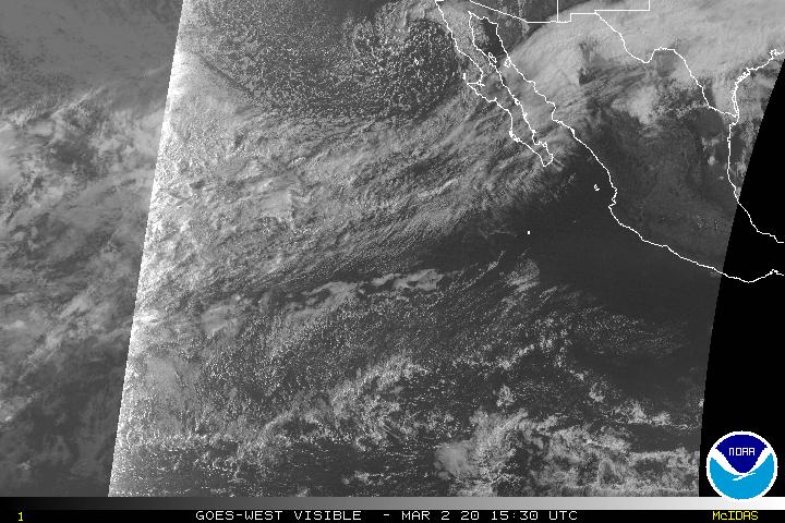
Figure 1. Tropical Storm Enrique (left) and Hurricane Dolores (right), as of 1830 GMT (2:30 pm EDT) on Thursday, July 16. Image credit: NOAA.
Dolores to send moisture into southwest U.S.
Hurricane Dolores continues churning through the Northeast Pacific as a Category 3 storm. At 11:00 am EDT, the center of Dolores was located about 240 miles south-southwest of Cabo San Lucas, Mexico. Peak sustained winds were just above the Cat. 3 threshold, at 115 mph. Dolores is moving steadily northwest at about 7 mph. As it encounters colder waters and greater wind shear, Dolores should begin to weaken by Friday, if not sooner.
Dolores’s southern (weaker) eyewall passed over tiny Socorro Island, about 370 miles west of Mexico’s west coast, on Wednesday. According to weather.com, an automated weather station reported winds of 80 mph, with gusts to 114 mph. There were no immediate reports of damage from the island, which hosts a small naval station. Officers there could be excused for some nervousness during a major El Niño event. In September 1997, during the onset of the last El Niño that was comparable in strength to the current one, Category 5 Hurricane Linda became the Northeast Pacific’s strongest tropical cyclone on record. Linda passed just south of Socorro Island (the only land area affected by the storm), putting the island in its northern eyewall while packing winds of 150 knots (more than 170 mph) and a central pressure of 905 mph. Some damage to meteorological equipment was reported.
Models are now in general agreement that Dolores will continue moving west-northwest and weaken before it has a chance to recurve toward the Pacific coast (although I would not be surprised if the cyclone holds together longer than usual for such a system). A moisture plume now extending from Dolores across southern Baja California is expected to push into the southwest U.S. by this weekend. Precipitable water—the amount of moisture above a given spot—is projected to climb as high as 2” over the lower Colorado Valley by Friday night. NOAA’s Weather Prediction Center is calling for a slight chance of rainfall exceeding the local flash flood guidance values across central Arizona on Friday and Saturday.
Further west, Tropical Storm Enrique is doggedly clinging to life. Although little convection is evident, RapidScat data from the International Space Station continues to indicate tropical storm force winds, according to the National Hurricane Center. NHC projects Enrique to become a depression by Thursday night and a remnant low by Friday night.
Bob Henson
Video 1. Infrared imagery from Japan’s Himiwari-8 satellite shows the evolution of Typhoon Nangka as it makes landfall on Japan’s south coast. Image credit: NWS Ocean Prediction Center, via #GRPG.
On the heels of Nangka is Tropical Storm Halola, now located about 170 miles west-southwest of Wake Island. Halola has weakened over the last 12 – 24 hours, thanks to moderate westerly shear (15 – 20 mph), but conditions will support restrengthening as Halola begins bending around a strong ridge to its north and wind shear decreases. There is model disagreement over Halola’s eventual track next week: the 0000 GMT Thursday run of the ECWMF model keeps Halola moving westward to Japan’s latitude, while the last several GFS runs have consistently recurved Halola before it has a chance to threaten Japan. There is plenty of time for track forecasts to evolve over the next few days.
Figure 1. Tropical Storm Enrique (left) and Hurricane Dolores (right), as of 1830 GMT (2:30 pm EDT) on Thursday, July 16. Image credit: NOAA.
Dolores to send moisture into southwest U.S.
Hurricane Dolores continues churning through the Northeast Pacific as a Category 3 storm. At 11:00 am EDT, the center of Dolores was located about 240 miles south-southwest of Cabo San Lucas, Mexico. Peak sustained winds were just above the Cat. 3 threshold, at 115 mph. Dolores is moving steadily northwest at about 7 mph. As it encounters colder waters and greater wind shear, Dolores should begin to weaken by Friday, if not sooner.
Dolores’s southern (weaker) eyewall passed over tiny Socorro Island, about 370 miles west of Mexico’s west coast, on Wednesday. According to weather.com, an automated weather station reported winds of 80 mph, with gusts to 114 mph. There were no immediate reports of damage from the island, which hosts a small naval station. Officers there could be excused for some nervousness during a major El Niño event. In September 1997, during the onset of the last El Niño that was comparable in strength to the current one, Category 5 Hurricane Linda became the Northeast Pacific’s strongest tropical cyclone on record. Linda passed just south of Socorro Island (the only land area affected by the storm), putting the island in its northern eyewall while packing winds of 150 knots (more than 170 mph) and a central pressure of 905 mph. Some damage to meteorological equipment was reported.
Models are now in general agreement that Dolores will continue moving west-northwest and weaken before it has a chance to recurve toward the Pacific coast (although I would not be surprised if the cyclone holds together longer than usual for such a system). A moisture plume now extending from Dolores across southern Baja California is expected to push into the southwest U.S. by this weekend. Precipitable water—the amount of moisture above a given spot—is projected to climb as high as 2” over the lower Colorado Valley by Friday night. NOAA’s Weather Prediction Center is calling for a slight chance of rainfall exceeding the local flash flood guidance values across central Arizona on Friday and Saturday.
Further west, Tropical Storm Enrique is doggedly clinging to life. Although little convection is evident, RapidScat data from the International Space Station continues to indicate tropical storm force winds, according to the National Hurricane Center. NHC projects Enrique to become a depression by Thursday night and a remnant low by Friday night.
Bob Henson
updated animation: Typhoon #Nangka landfall across Shikoku Island, Japan IR imgs from Himawari, tks again to #GRPG pic.twitter.com/97YuTX3s5B
— NWS OPC (@NWSOPC) July 16, 2015Video 1. Infrared imagery from Japan’s Himiwari-8 satellite shows the evolution of Typhoon Nangka as it makes landfall on Japan’s south coast. Image credit: NWS Ocean Prediction Center, via #GRPG.
The views of the author are his/her own and do not necessarily represent the position of The Weather Company or its parent, IBM.