WunderBlog Archive » Category 6™
Category 6 has moved! See the latest from Dr. Jeff Masters and Bob Henson here.Tornadoes, Record Downpours Possible This Weekend Over Parts of Plains
Residents of Oklahoma and Texas may need to watch the skies en route to holiday shopping or partying on Saturday, as a severe weather outbreak is possible. A powerful upper-level jet stream bearing winds of more than 170 mph (see Figure 1) is slamming into the West Coast this morning and will carve out a sharp trough over the Southern Plains on Saturday. Very warm air is already in place--record or near-record highs in the upper 70s and low 80s are expected on Friday over western Oklahoma and Texas--and the approaching trough will lead to a rapid return of rich Gulf moisture by Saturday. In its Day 2 forecast issued Friday morning, NOAA’s Storm Prediction Center called for a a slight risk of severe weather on Saturday (see Figure 1). Instability could be meager if thick clouds end up cutting back on sunshine. Yet even the modestly unstable air typical of this time of year can be enough for tornadic storms when a potent upper-level storm brings strong vertical wind shear, which helps foster thunderstorm rotation.
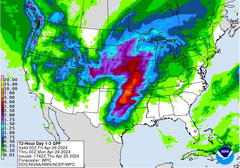
Even if tornadic supercells fail to develop, a nighttime squall line with heavy rain and high wind is a fairly good bet. This is already the wettest year on record for Dallas-Fort Worth, where only 1.22” is needed to reach the 60-inch mark. Values of precipitable water (the amount of water vapor available in the atmosphere) may set record highs for December from the Southern Plains into the Midwest. Rains of 2” - 4” or more will be widespread toward Arkansas and Louisiana by Sunday as the squall line sweeps east. A second focus of very heavy rain (2” or more) will extend from Iowa into Wisconsin, where downpours are rare in December. Some locations in the Midwest could rack up monthly records for their heaviest 1- or 2-day rains. However, SPC is only predicting a marginal risk of severe weather on Sunday due to extensive cloudiness and rain-cooled air.

Figure 1. The Day 2 convective outlook produced by NOAA’s Storm Prediction Center, issued at 0555Z Friday, December 11, 2015 (11:55 pm CST Thursday), and valid on Saturday.

Figure 2. WunderMap depiction of wind speeds (in knots) at 200 mb (about 30,000 feet) predicted by the 06Z Friday run of the GFS model for 6 pm CST Saturday evening, December 12, 2015.

Figure 3. Rainfall projected from 12Z (6:00 am CDT) Friday, December 11, 2015, through 12Z Monday, December 14. Image credit: NWS Weather Prediction Center.
Oklahoma’s history of holiday twisters
A surprising number of tornadoes have targeted Oklahoma during the final month of the year. For the official period of record, starting in 1950, the state has seen a total of 25 tornadoes during December. The most injurious of the bunch was on December 5, 1975, when 38 people were hurt by an F3 tornado that caused extensive damage in northeast Tulsa. (Here’s a Tulsa World gallery with some excellent archival photos.) On Christmas Eve morning of 1982, a pair of twisters injured 17 people, again in the Tulsa area, and on New Year’s Eve 2010, a tornado ripped across a 21-mile path from northeast Oklahoma into northwest Arkansas.
Rare December tornado hits the Columbia Valley of Washington
The upper-level storm heading for Oklahoma has already led to some tornadic trouble. Three dozen homes were damaged late Thursday morning by an EF1 tornado that moved through the Washington town of Battle Ground, just north of the Columbia River, with winds topping 100 mph. Washington and Oregon each average a couple of tornadoes per year, scattered across the calendar. Nearly all are rated F/EF0 or F/EF1 on the Fujita scale. According to the Tornado History Project, the Battle Ground twister was the state’s fifth on record for the month of December since 1950. No serious injuries or fatalities were reported, which keeps the nation on track for what could be its lowest annual tornado death toll in at least 141 years.
Coming soon: the latest science from AGU and the outcome from Paris
Jeff Masters and I will be covering the American Geophysical Union’s 48th Fall Meeting in San Francisco next week. We’ll also report on the landmark global climate agreement that’s expected to be finalized late Friday or Saturday in Paris. The Guardian’s live blog is producing hour-by-hour live-blog coverage of the negotiations and related protests.
Have a great weekend, everyone!
Bob Henson
Even if tornadic supercells fail to develop, a nighttime squall line with heavy rain and high wind is a fairly good bet. This is already the wettest year on record for Dallas-Fort Worth, where only 1.22” is needed to reach the 60-inch mark. Values of precipitable water (the amount of water vapor available in the atmosphere) may set record highs for December from the Southern Plains into the Midwest. Rains of 2” - 4” or more will be widespread toward Arkansas and Louisiana by Sunday as the squall line sweeps east. A second focus of very heavy rain (2” or more) will extend from Iowa into Wisconsin, where downpours are rare in December. Some locations in the Midwest could rack up monthly records for their heaviest 1- or 2-day rains. However, SPC is only predicting a marginal risk of severe weather on Sunday due to extensive cloudiness and rain-cooled air.
Figure 1. The Day 2 convective outlook produced by NOAA’s Storm Prediction Center, issued at 0555Z Friday, December 11, 2015 (11:55 pm CST Thursday), and valid on Saturday.
Figure 2. WunderMap depiction of wind speeds (in knots) at 200 mb (about 30,000 feet) predicted by the 06Z Friday run of the GFS model for 6 pm CST Saturday evening, December 12, 2015.
Figure 3. Rainfall projected from 12Z (6:00 am CDT) Friday, December 11, 2015, through 12Z Monday, December 14. Image credit: NWS Weather Prediction Center.
Oklahoma’s history of holiday twisters
A surprising number of tornadoes have targeted Oklahoma during the final month of the year. For the official period of record, starting in 1950, the state has seen a total of 25 tornadoes during December. The most injurious of the bunch was on December 5, 1975, when 38 people were hurt by an F3 tornado that caused extensive damage in northeast Tulsa. (Here’s a Tulsa World gallery with some excellent archival photos.) On Christmas Eve morning of 1982, a pair of twisters injured 17 people, again in the Tulsa area, and on New Year’s Eve 2010, a tornado ripped across a 21-mile path from northeast Oklahoma into northwest Arkansas.
Rare December tornado hits the Columbia Valley of Washington
The upper-level storm heading for Oklahoma has already led to some tornadic trouble. Three dozen homes were damaged late Thursday morning by an EF1 tornado that moved through the Washington town of Battle Ground, just north of the Columbia River, with winds topping 100 mph. Washington and Oregon each average a couple of tornadoes per year, scattered across the calendar. Nearly all are rated F/EF0 or F/EF1 on the Fujita scale. According to the Tornado History Project, the Battle Ground twister was the state’s fifth on record for the month of December since 1950. No serious injuries or fatalities were reported, which keeps the nation on track for what could be its lowest annual tornado death toll in at least 141 years.
Coming soon: the latest science from AGU and the outcome from Paris
Jeff Masters and I will be covering the American Geophysical Union’s 48th Fall Meeting in San Francisco next week. We’ll also report on the landmark global climate agreement that’s expected to be finalized late Friday or Saturday in Paris. The Guardian’s live blog is producing hour-by-hour live-blog coverage of the negotiations and related protests.
Have a great weekend, everyone!
Bob Henson
More details about the path and damage from today's tornado in Battle Ground pic.twitter.com/zFKf4VOMgx
— NWS Portland (@NWSPortland) December 11, 2015Severe Weather Tornado Extreme Weather
The views of the author are his/her own and do not necessarily represent the position of The Weather Company or its parent, IBM.