WunderBlog Archive » Category 6™
Category 6 has moved! See the latest from Dr. Jeff Masters and Bob Henson here.The Beta Effect
Yesterday I talked about the steering of tropical cyclones by the mean wind in a steering layer determined by the system's minimum central pressure (revisit the relevant graphic). For strong hurricanes, the steering layer spans a large portion of the troposphere. For example, the steering layer for a hurricane with minimum central pressure between 940 mb and 949 mb spans from 850 mb (roughly 5000 feet) to 250 mb (roughly 35000 feet). The mean wind in this layer (the "steering wind") accounts for roughly 80% to 90% of the hurricane's motion.
As I briefly mentioned yesterday, about 10% to 20% of the storm's motion arises from the Beta effect. You might think that forecasting the track of tropical cyclones would thus be "child's play." But modeling the Beta effect isn't easy. The Beta effect gets even more complicated when tropical cyclones are moving briskly and undergoing rapid changes in intensity. Lesson learned: Predicting the tracks of tropical cyclones, though forecasters continue to improve, is not an exact science. Sometimes, it's far from it.
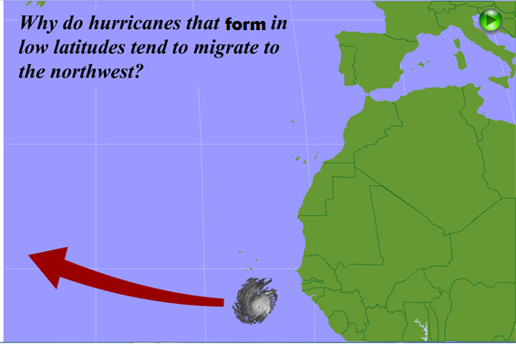
Hurricanes moving due westward tend to drift northwestward in time. Why? Stay tuned.
What is the Beta effect? For starters, let's agree to restrict our discussion to the Atlantic Ocean in the Northern Hemisphere. In a nutshell, the Beta effect arises from the variation of the Coriolis parameter with latitude. This variation of the Coriolis parameter is the primary reason why hurricanes forming at low latitudes tend to drift northwestward (see schematic above) from their westward track (for simplicity, I'm assuming here that the mean wind in the deep steering layer blows from east to west across the Atlantic Ocean).
Before we delve into the nuts and bolts of the Beta effect, I need to make sure that all my readers are on the same page with regard to some of the basic concepts about vorticity that are relevant to this discussion. First, vorticity is simply the measure of the spin around an axis. For the most part, synoptic meteorologists are interested in the spin around the local vertical, which is simply a line drawn from a point on the earth's surface to the center of the earth (here's an idealized schematic of a few local verticals, courtesy of A World of Weather: Fundamentals of Meteorology). This "vertical vorticity" (spin around a local vertical) is not fast by most standards. For sake of comparison, the vertical vorticity of a tornado with a diameter of 100 meters is roughly 10,000 to 100,000 times greater than the vertical vorticity that's relevant in synoptic meteorology. Nonetheless, such seemingly slow spin plays a pivotal role in weather.
.png)
An idealized schematic showing a 500-mb ridge (left) and a 500-mb trough (right). 500-mb height lines are the thin, dark contours, and the capsule-shaped features represent air parcels. Note how an air parcel moving through the ridge gains anticyclonic spin (negative relative vorticity) and an air parcel moving through the trough gains cyclonic spin (positive relative vorticity). Courtesy of A World of Weather: Fundamentals of Meteorology.
There are two sources of vorticity that weather forecasters weigh. The first is relative vorticity, which is generated by the curvature of isobars or height contours on a constant pressure surface. For example, an air parcel shaped like a Tylenol capsule acquires relative vorticity as it simply flows through 500-mb troughs and ridges (check out this idealized schematic above, courtesy of A World of Weather: Fundamentals of Meteorology). To get your bearings, the contours that form the ridge and trough are 500-mb height lines. At any rate, air parcels acquire cyclonic vorticity (by convention, a positive number) as they round the bend in the trough, and anticyclonic vorticity (negative relative vorticity) as they negotiate the curve in the ridge.
.png)
Horizontal wind shear produces anticyclonic relative vorticity in a 500-mb ridge (left) and cyclonic relative vorticity near the base of a 500-mb trough (right). Courtesy of A World of Weather: Fundamentals of Meteorology.
Horizontal wind shear, which is the change in wind speed and/or wind direction over a horizontal distance, is also a source of relative vorticity. In the idealized schematic above, air parcels appear as little fans. The green vectors represent the wind (the longer green vectors correspond to faster winds). And so, you can get the sense that horizontal wind shear in troughs and ridges cause the fans to rotate, creating cyclonic vorticity in the trough and anticyclonic vorticity in the ridge.
The second type of vertical velocity is planetary vorticity (alternatively, earth vorticity), which is spin around a local vertical induced by the rotation of the earth (check out the idealized schematic below, courtesy of A World of Weather: Fundamentals of Meteorology). Note that earth vorticity increases with increasing latitude. In other words, earth vorticity at the equator is zero, and earth vorticity at the North Pole is a maximum. The relatively small values of earth vorticity in the Tropics accounts for the reason why tropical cyclones must form a minimum distance of 500 kilometers (about 300 miles) from the equator (in order to develop a cyclonic circulation). There are exceptions to this rule, of course...Typhoon Vamei in 2001, for example.
.png)
Earth vorticity increases from zero at the equator to a maximum at the North Pole. Courtesy of A World of Weather: Fundamentals of Meteorology.
Back to the basics of vertical vorticity (I'll sometimes drop the "vertical" and simply write, "vorticity." At any rate, absolute vorticity is simply the sum of relative vorticity and earth vorticity. Okay, we're ready to delve into the Beta effect and to understand why hurricanes moving due west tend to drift northwestward with time (to see what I mean, check out the first slide of the flash animation below). As you read through the following paragraph, please revisit this flash animation, which you can advance by clicking on the forward button in the upper-right corner.
The Beta effect helps to control the movement of tropical cyclones (the mean wind in the steering layer controls 80% to 90% of the storm's movement). Explore the nifty flash animation above to see why (click on the forward button in the upper-right corner). In general, the Beta effect causes westward-moving storms to move to the right (N.H.) of the steering wind (the mean wind in the steering layer). In the absence of a steering wind, an apparently motionless hurricane will drift toward the northwest in response to the Beta effect (I'm assuming we're in the Northern Hemisphere). Courtesy of Penn State's online Certificate Program.
Okay, air parcels moving southward on the western flank of the tropical cyclone's center lose earth vorticity. On the eastern side of the storm, northward-moving air parcels gain earth vorticity (the Coriolis parameter, which depends on latitude, increases with increasing latitude). As it turns out, absolute vorticity associated with hurricanes tends to be conserved above the boundary layer. Thus, the relative vorticity of southward-bound air parcels must increase on the hurricane's western flank to offset their loss of earth vorticity. Similarly, the relative vorticity of northward-bound parcels must decrease on the eastern flank of the storm to compensate for their gain in earth vorticity. As a result, two centers of positive and negative relative vorticity form to the west and east of the hurricane's center (respectively). In response, two secondary circulations develop (cyclonic around the center of positive relative vorticity, and anticyclonic around the center of negative relative vorticity). Please note that you can't observe these circulations on satellite loops because their orders of magnitude are so much smaller than the hurricane's circulation.
Nonetheless, these circulations associated with the Beta effect are sufficiently large to cause a westward-moving hurricane to drift northwestward. Moreover, the Beta effect is the reason why tropical cyclones flirting with crossing the equator swerve to the northeast before it's too late.
To my knowledge, there haven't been any tropical cyclones that have crossed the equator, but a few have come close, particularly in the northern Indian Ocean. But is it possible, Grenci? I would answer "yes." That's because a tropical cyclone's relatively large cyclonic relative vorticity would not initially be affected by the weak change in the Coriolis force as it crossed into the opposite hemisphere (eventually, of course, the circulation of a hemisphere-swapping hurricane would become anticyclonic and dissipate). And, as I just discussed, the Beta effect works against any crossover.
A clockwise-rotating disturbance over the North Atlantic on June 26-27, 2008. Apparently, the disturbance crossed the equator from the Southern Hemisphere. Courtesy of CIMSS.
Still, I can't deny that there are equator-crossing disturbances. To see what I mean, check out case of a anticyclonically rotating disturbance that apparently originated in the Southern Hemisphere and then crossed the equator into the Northern Hemisphere on June 27, 2008 (see satellite animation above). In my opinion, some really cool stuff!
Here endeth the lesson.
Lee
As I briefly mentioned yesterday, about 10% to 20% of the storm's motion arises from the Beta effect. You might think that forecasting the track of tropical cyclones would thus be "child's play." But modeling the Beta effect isn't easy. The Beta effect gets even more complicated when tropical cyclones are moving briskly and undergoing rapid changes in intensity. Lesson learned: Predicting the tracks of tropical cyclones, though forecasters continue to improve, is not an exact science. Sometimes, it's far from it.
Hurricanes moving due westward tend to drift northwestward in time. Why? Stay tuned.
What is the Beta effect? For starters, let's agree to restrict our discussion to the Atlantic Ocean in the Northern Hemisphere. In a nutshell, the Beta effect arises from the variation of the Coriolis parameter with latitude. This variation of the Coriolis parameter is the primary reason why hurricanes forming at low latitudes tend to drift northwestward (see schematic above) from their westward track (for simplicity, I'm assuming here that the mean wind in the deep steering layer blows from east to west across the Atlantic Ocean).
Before we delve into the nuts and bolts of the Beta effect, I need to make sure that all my readers are on the same page with regard to some of the basic concepts about vorticity that are relevant to this discussion. First, vorticity is simply the measure of the spin around an axis. For the most part, synoptic meteorologists are interested in the spin around the local vertical, which is simply a line drawn from a point on the earth's surface to the center of the earth (here's an idealized schematic of a few local verticals, courtesy of A World of Weather: Fundamentals of Meteorology). This "vertical vorticity" (spin around a local vertical) is not fast by most standards. For sake of comparison, the vertical vorticity of a tornado with a diameter of 100 meters is roughly 10,000 to 100,000 times greater than the vertical vorticity that's relevant in synoptic meteorology. Nonetheless, such seemingly slow spin plays a pivotal role in weather.
An idealized schematic showing a 500-mb ridge (left) and a 500-mb trough (right). 500-mb height lines are the thin, dark contours, and the capsule-shaped features represent air parcels. Note how an air parcel moving through the ridge gains anticyclonic spin (negative relative vorticity) and an air parcel moving through the trough gains cyclonic spin (positive relative vorticity). Courtesy of A World of Weather: Fundamentals of Meteorology.
There are two sources of vorticity that weather forecasters weigh. The first is relative vorticity, which is generated by the curvature of isobars or height contours on a constant pressure surface. For example, an air parcel shaped like a Tylenol capsule acquires relative vorticity as it simply flows through 500-mb troughs and ridges (check out this idealized schematic above, courtesy of A World of Weather: Fundamentals of Meteorology). To get your bearings, the contours that form the ridge and trough are 500-mb height lines. At any rate, air parcels acquire cyclonic vorticity (by convention, a positive number) as they round the bend in the trough, and anticyclonic vorticity (negative relative vorticity) as they negotiate the curve in the ridge.
Horizontal wind shear produces anticyclonic relative vorticity in a 500-mb ridge (left) and cyclonic relative vorticity near the base of a 500-mb trough (right). Courtesy of A World of Weather: Fundamentals of Meteorology.
Horizontal wind shear, which is the change in wind speed and/or wind direction over a horizontal distance, is also a source of relative vorticity. In the idealized schematic above, air parcels appear as little fans. The green vectors represent the wind (the longer green vectors correspond to faster winds). And so, you can get the sense that horizontal wind shear in troughs and ridges cause the fans to rotate, creating cyclonic vorticity in the trough and anticyclonic vorticity in the ridge.
The second type of vertical velocity is planetary vorticity (alternatively, earth vorticity), which is spin around a local vertical induced by the rotation of the earth (check out the idealized schematic below, courtesy of A World of Weather: Fundamentals of Meteorology). Note that earth vorticity increases with increasing latitude. In other words, earth vorticity at the equator is zero, and earth vorticity at the North Pole is a maximum. The relatively small values of earth vorticity in the Tropics accounts for the reason why tropical cyclones must form a minimum distance of 500 kilometers (about 300 miles) from the equator (in order to develop a cyclonic circulation). There are exceptions to this rule, of course...Typhoon Vamei in 2001, for example.
Earth vorticity increases from zero at the equator to a maximum at the North Pole. Courtesy of A World of Weather: Fundamentals of Meteorology.
Back to the basics of vertical vorticity (I'll sometimes drop the "vertical" and simply write, "vorticity." At any rate, absolute vorticity is simply the sum of relative vorticity and earth vorticity. Okay, we're ready to delve into the Beta effect and to understand why hurricanes moving due west tend to drift northwestward with time (to see what I mean, check out the first slide of the flash animation below). As you read through the following paragraph, please revisit this flash animation, which you can advance by clicking on the forward button in the upper-right corner.
The Beta effect helps to control the movement of tropical cyclones (the mean wind in the steering layer controls 80% to 90% of the storm's movement). Explore the nifty flash animation above to see why (click on the forward button in the upper-right corner). In general, the Beta effect causes westward-moving storms to move to the right (N.H.) of the steering wind (the mean wind in the steering layer). In the absence of a steering wind, an apparently motionless hurricane will drift toward the northwest in response to the Beta effect (I'm assuming we're in the Northern Hemisphere). Courtesy of Penn State's online Certificate Program.
Okay, air parcels moving southward on the western flank of the tropical cyclone's center lose earth vorticity. On the eastern side of the storm, northward-moving air parcels gain earth vorticity (the Coriolis parameter, which depends on latitude, increases with increasing latitude). As it turns out, absolute vorticity associated with hurricanes tends to be conserved above the boundary layer. Thus, the relative vorticity of southward-bound air parcels must increase on the hurricane's western flank to offset their loss of earth vorticity. Similarly, the relative vorticity of northward-bound parcels must decrease on the eastern flank of the storm to compensate for their gain in earth vorticity. As a result, two centers of positive and negative relative vorticity form to the west and east of the hurricane's center (respectively). In response, two secondary circulations develop (cyclonic around the center of positive relative vorticity, and anticyclonic around the center of negative relative vorticity). Please note that you can't observe these circulations on satellite loops because their orders of magnitude are so much smaller than the hurricane's circulation.
Nonetheless, these circulations associated with the Beta effect are sufficiently large to cause a westward-moving hurricane to drift northwestward. Moreover, the Beta effect is the reason why tropical cyclones flirting with crossing the equator swerve to the northeast before it's too late.
To my knowledge, there haven't been any tropical cyclones that have crossed the equator, but a few have come close, particularly in the northern Indian Ocean. But is it possible, Grenci? I would answer "yes." That's because a tropical cyclone's relatively large cyclonic relative vorticity would not initially be affected by the weak change in the Coriolis force as it crossed into the opposite hemisphere (eventually, of course, the circulation of a hemisphere-swapping hurricane would become anticyclonic and dissipate). And, as I just discussed, the Beta effect works against any crossover.
A clockwise-rotating disturbance over the North Atlantic on June 26-27, 2008. Apparently, the disturbance crossed the equator from the Southern Hemisphere. Courtesy of CIMSS.
Still, I can't deny that there are equator-crossing disturbances. To see what I mean, check out case of a anticyclonically rotating disturbance that apparently originated in the Southern Hemisphere and then crossed the equator into the Northern Hemisphere on June 27, 2008 (see satellite animation above). In my opinion, some really cool stuff!
Here endeth the lesson.
Lee
The views of the author are his/her own and do not necessarily represent the position of The Weather Company or its parent, IBM.