WunderBlog Archive » Category 6™
Category 6 has moved! See the latest from Dr. Jeff Masters and Bob Henson here.Ophelia stronger; threat to North Carolina increases
The 1:17 pm EDT hurricane hunter mission saw no drop in pressure, but did visually observe 90 knot surface winds (105 mph), which would make Ophelia a Category 2 hurricane. The flight level winds were only 77 knots, though, so NHC will probably not upgrade Ophelia to a Category 2 storm yet. Satellite imagery shows the formation of an eye for the first time. The upper level outflow to the south is improving, and it now appears that most of the dry air that plagued the hurricane this morning has mixed out. Steady but slow intensification will likely continue, and Ophelia will probably be a Category 2 hurricane on Sunday.
The latest 8am EDT (12Z) model runs show an increased threat to North Carolina. The NOGAPS model has Ophelia hitting the Outer Banks of North Carolina Wednesday, then moving up the coast to hit Long Island, NY as a strong tropical storm or Category 1 hurricane on Thursday. The latest GFS run puts Ophelia ashore near Wilmington, NC on Wednesday, and then tracks her along the length of the NC coast and out to sea. The 12Z GFDL model has landfall occuring Tuesday near Wilmington, NC, as a Category 2 storm. The 12Z UKMET has landfall Thursday on the Outer Banks. Only the Canadian model puts Ophelia ashore in South Carolina. Overall, the models have steadily been shifting their landfall points further and further northwards, making North Carolina increasingly likely as a landfall point--and also increasing the chances that Ophelia will miss the U.S. entirely and recurve out to sea. New England and the mid-Atlantic states need to pay close attention to this storm as well; Ophelia may be coming your way late in the week next week.
The most likely scenario now appears to be a strike Tuesday or Wednesday in North Carolina as a strong Category 2 hurricane. As usual, all this is subject to a high degree of uncertainty. South Carolina is still at high risk, and Georgia still at some risk. Remember that a hurricane is not a point, and the effects of this hurricane will be felt over a wide area. Also keep in mind that the median track error for the NHC 3-day forecasts is about 230 miles, meaning that half of the time, the forecast is worse than that. Three-day intensity forecasts are in error by an average of one full category--25 mph. All residents of the Georgia, South Carolina, and North Carolina coasts need to be prepared for what will most likely be a Category 2 hurricane, but could be a Category 3.
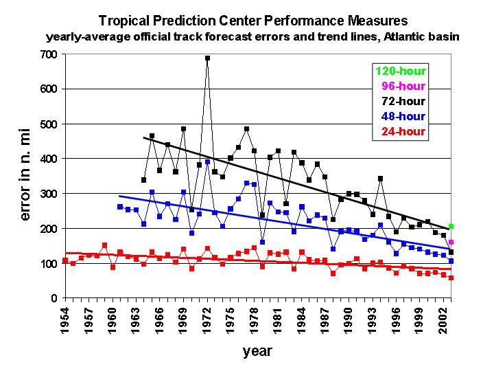
Figure 1. Average track error of official National Hurricane Center Forecasts (in nautical miles, multiply by 1.15 get get the result in miles). Image credit: Dr. Chris Landsea, NOAA/AOML Hurricane Research Division.
Dr. Jeff Masters
The latest 8am EDT (12Z) model runs show an increased threat to North Carolina. The NOGAPS model has Ophelia hitting the Outer Banks of North Carolina Wednesday, then moving up the coast to hit Long Island, NY as a strong tropical storm or Category 1 hurricane on Thursday. The latest GFS run puts Ophelia ashore near Wilmington, NC on Wednesday, and then tracks her along the length of the NC coast and out to sea. The 12Z GFDL model has landfall occuring Tuesday near Wilmington, NC, as a Category 2 storm. The 12Z UKMET has landfall Thursday on the Outer Banks. Only the Canadian model puts Ophelia ashore in South Carolina. Overall, the models have steadily been shifting their landfall points further and further northwards, making North Carolina increasingly likely as a landfall point--and also increasing the chances that Ophelia will miss the U.S. entirely and recurve out to sea. New England and the mid-Atlantic states need to pay close attention to this storm as well; Ophelia may be coming your way late in the week next week.
The most likely scenario now appears to be a strike Tuesday or Wednesday in North Carolina as a strong Category 2 hurricane. As usual, all this is subject to a high degree of uncertainty. South Carolina is still at high risk, and Georgia still at some risk. Remember that a hurricane is not a point, and the effects of this hurricane will be felt over a wide area. Also keep in mind that the median track error for the NHC 3-day forecasts is about 230 miles, meaning that half of the time, the forecast is worse than that. Three-day intensity forecasts are in error by an average of one full category--25 mph. All residents of the Georgia, South Carolina, and North Carolina coasts need to be prepared for what will most likely be a Category 2 hurricane, but could be a Category 3.
Figure 1. Average track error of official National Hurricane Center Forecasts (in nautical miles, multiply by 1.15 get get the result in miles). Image credit: Dr. Chris Landsea, NOAA/AOML Hurricane Research Division.
Dr. Jeff Masters
The views of the author are his/her own and do not necessarily represent the position of The Weather Company or its parent, IBM.