WunderBlog Archive » Category 6™
Category 6 has moved! See the latest from Dr. Jeff Masters and Bob Henson here.More Record Heat Invading the U.S. as Cleanup From Rare February Tornadoes Begins
Record warmth slathered the Northeast on Friday and Saturday, the latest chapter in a phenomenal sequence of unseasonal mildness during the last half of February. As of Monday morning, NOAA’s U.S. Records site had catalogued 5857 daily record highs for the month, with only 95 daily record lows. Most of the record lows have occurred across the western U.S., whereas the bulk of record warmth has been east of the Rockies. The warmth has been even more impressive when you look at the ratio of monthly records: 408 record monthly highs thus far, versus just one record monthly low.
Our pick for the most astounding single report of the weekend comes from Vermont’s largest city, Burlington, which soared to 72°F on Saturday afternoon. This broke multiple records by incredible margins:
Previous daily record high: 55°F (broken by 8 AM EST Sat!)
Previous monthly record high: 63°F, set on Thursday, Feb. 23 (which had broken the longstanding record of 62°F from Feb. 19, 1981)
Previous high for any winter month: 68°F on Dec. 24, 2015
The reading also tied Vermont’s state record high for February, which had been set in Bennington just a day earlier. New Hampshire also set a state record on Friday with 73°F in Nashua, according to WU weather historian Christopher Burt. Other all-time state records for February set this month include Oklahoma (99°F at Magnum on Feb. 11) and Wisconsin (72°F at Janesville and Boscobel on Feb. 22, with multiple stations breaking the previous state record of 69°F).
Record February warmth extended last week into Canada, where Nova Scotia recorded their warmest February reading on record, 20.0°C (68°F) at Greenwood on February 25, 2017 (previous record: 19.5°C set at Windsor Martock on 20 Feb 1994 and at Margaree Forks on 28 Feb 2000.) Toronto’s Pearson Airport set its all-time record for February with a temperature of 17.2°C (63°F) on February 23, 2017 (previous record: 14.9°C (58.8°F) set on Feb. 23, 1984.) Thanks go to Maximiliano Herrera and Christopher C.. Burt for the Canada info.

Figure 1. Many locations across the eastern two-thirds of the U.S. are on track to achieve their warmest February on record (red “1”) for rankings compiled across the period Feb. 1-26. Image credit: Southeastern Regional Climate Center.
More record-warm mildness expected in eastern half of the U.S. on Tuesday and Wednesday
Last week’s warm weather ended with a bang across eastern New York and New England on Saturday, as a sharp cold front sent the temperature plummeting more than 30°F in just a few hours. However, record-warm temperatures of 30°F or more above average are expected to invade a large portion of the U.S. again on Tuesday and Wednesday, thanks to a resumption of the jet stream pattern that brought last week’s record warmth.

Figure 2. Departure of surface temperature from average as predicted by the 00Z Monday, February 27, 2017 run of the GFS model for 7 pm EST Tuesday, February 28, 2017. Record-warm temperatures of 30°F or more above average are expected over a large portion of the eastern half of the U.S. Note also that another remarkable surge of warm air is predicted to pass over Greenland and into the Arctic, which has seen record-low sea ice extent this winter due to repeated incursions of warm air. Image credit: Climate Reanalyzer™ (http://cci-reanalyzer.org), Climate Change Institute, University of Maine, Orono, Maine.

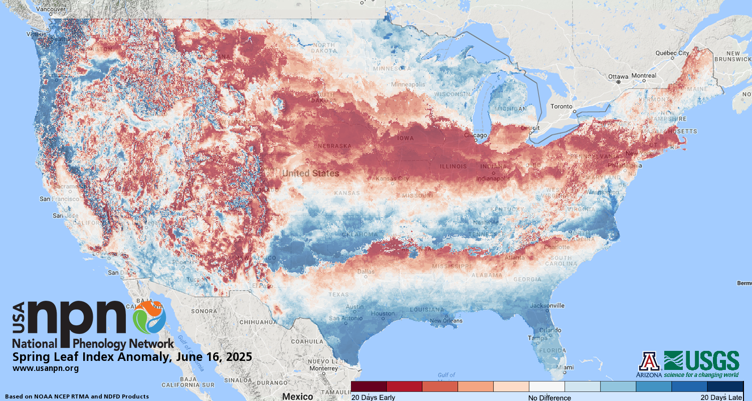
Figure 3. Leaf data compiled by the National Phenology Network show that vegetation is running three weeks ahead of average as far north as Kansas City, MO; Columbus, OH; and Philadelphia, PA. Image credit: U.S. National Phenology Network.
Spring is already 3 weeks ahead of schedule
Spring is already three or more weeks ahead of schedule across much of the U.S., and in Washington, D.C., is 22 days ahead of schedule, according to the USA National Phenology Network. These estimates were made using nature’s calendar—for example, when flowers bloom, trees begin to leaf out, and birds build their nests. According to a 2015 study by Allstadt et al., this year’s early arrival of spring will be typical by the year 2100. By that time, assuming a business-as-usual approach to burning fossil fuels, spring will arrive, on average, about 23 days earlier it does in the present climate. Over the past thirty years, spring has come an average of 3 - 5 days earlier across most of the U.S., when comparing the period 1991-2010 vs. 1961-1980 (Figure 4.)

Figure 4. Over the past thirty years, spring has come an average of 3 - 5 days earlier across most of the U.S. (when comparing the period 1991-2010 vs. 1961-1980.) Image credit: Climate Central.
Springtime warmth a classic signal of U.S. climate change
With a few exceptions, warm temperatures are becoming more likely year round as a result of human-produced greenhouse gases, but the signal appears to be especially strong during the months of meteorological spring in the Northern Hemisphere (March through May). Snow cover across the hemisphere has shown little significant trend over the months from autumn through January, but there has been a distinct decline in snow cover over recent decades from February through June, as shown in monthly analyses from the Rutgers Snow Lab. “We’ve known for over a decade now that climate change is variably advancing the onset of spring across the United States,” reports the National Phenology Network.
Warmth that comes too soon in late winter and spring can be thoroughly enjoyable for us humans, but it can be devastating for crops and ecosystems that depend on reliable seasonal signals, as Bob Henson discussed on NPR’s “Weekend Edition” on Sunday. A case in point is the Great March Warm Wave of March 2012, which produced readings between 85°F and 90°F as far north as Michigan and southeastern Canada. Fruit crops burst into bloom across Michigan, only to be decimated by a more seasonable late-April freeze. Damages to apple, blueberry, grape, peach, and cherry crops totaled more than $200 million across Michigan alone, leading to the state’s worst crop failure on record.
Rare February tornadoes pummel the Northeast
Tornadoes aren’t super-common east of the Appalachians and north of the Mason-Dixon line at any time of year. During winter, they’re almost unheard of. Yet at least three tornadoes developed in Saturday’s burst of severe weather. Massachusetts experienced its first February tornado on record, as a damage survey on Sunday confirmed that an EF1 twister packing top winds of 110 mph swung along a 5-mile path across the towns of Goshen and Conway between 7:18 and 7:25 pm EST. The twister developed at the leading edge of an eastward-moving, fairly linear severe thunderstorm. Only one injury was reported, but downtown Conway experienced substantial damage, with many trees and power lines down. “Several people that we spoke to heard a tell-tale roaring sound and immediately sought shelter in their basements. It was very fortunate that nobody was killed in this event,” reported the National Weather Service office in Taunton, MA. Official tornado statistics extend back to 1950, but in a separate database assembled by Theodore Fujita and the University of Chicago that goes back to 1916 (published in the book “Significant Tornadoes 1680-1991”), there are no tornado reports from Massachusetts for February.
In Pennsylvania, only four tornadoes (two of them just last year) had been reported in any February prior to the EF2 powerhouse on Saturday that swept just east of the heavily populated Wilkes-Barre/Scranton corridor. After a damage survey conducted on Sunday, the NWS/Binghamton, NY, office placed a Facebook photo album online with a number of photos and analyses of the twister. It was clearly generated by a supercell thunderstorm--the type more common in the Midwest and Great Plains--with a prominent hook echo and very strong rotation evident on Doppler radar. Top winds of 120 mph were reported along a 12.8-mile-long, 500-yard-wide path. Two homes were extensively damaged and 28 others experienced at least some damage, but no injuries were reported. At least 1,000 trees were knocked down. Although the twister’s path ended very close to Lake Scranton, it was never classified as a waterspout, since it originated as a land-based tornado within a supercell thunderstorm.
One other twister struck on Saturday: an EF1 tornado confirmed about 2 miles north-northwest of La Plata, Maryland (the town devastated by an F4 tornado on April 28, 2002). This EF1 tornado generated top winds of 90 mph along its 8.4-mile-long, 125-yard-wide path. No injuries were reported, and damage was generally minor. This was the eighth February tornado in Maryland since reliable records began in 1950, reported the NWS office in Sterling, VA.

Figure 5. The large tree that crushed this truck was felled by an EF2 tornado that moved through Lackawanna and Luzerne Counties, Pennsylvania, on February 25, 2017. Image credit: Dennis Macheska and Jeffrey LaCoe, via NWS/Binghamton.

Figure 6. Path of the EF2 tornado in northeast Pennsylvania on February 25, 2017. The tornado roughly paralleled Interstate 476, moving just 2-3 miles southwest of the Wilkes-Barre/Scranton corridor. Image credit: Patrick Favola and NWS/Binghamton.
Non-tornadic storms also had a noteworthy impact in unusual places over the last few days. According to a weather.com wrap-up of the week’s wild weather, the damaging winds experienced in eastern New York on Saturday were the farthest-north severe reports in New York State on record for February. A severe storm produced wind damage in southeast Michigan on Friday--only the sixth day since 1950 with severe weather reported in the state of Michigan during February.
Multi-day round of severe weather expected early this week
More severe weather is likely over the next several days as warm, moist air again surges northeastward ahead of a potent upper-level trough swinging through the eastern U.S. As of Monday morning, the NWS Storm Prediction Center had placed a slight risk of severe weather for Monday across parts of northeast Texas. Any supercell that forms could spit out large hail, with high winds and a small risk of tornadoes in storms that push eastward through the region along a warm front into northern Louisiana. The severe threat will ramp up considerably on Tuesday and Wednesday, with a region of enhanced risk for Tuesday over and near northern Arkansas, and on Wednesday from northern Mississippi and Alabama into central eastern Tennessee and Kentucky.
Models are in some disagreement on storm development mode for Tuesday, but SPC notes that any tornado that develops across northeast Arkansas could be a strong one. By Wednesday night, severe storms packing high wind could make it all the way into the Washington-to-New York corridor, especially if warm, unstable air makes it back into the region soon enough. “I’m concerned about Wednesday evening,” meteorologist Steve Sosna (WNBC/New York) told me. “The trajectory of the surface low is very favorable for severe weather around here.”
Bob Henson and Jeff Masters


Figure 7. Severe weather outlook for Tuesday, February 28 (top) and Wednesday, March 1 (bottom), from NOAA’s Storm Prediction Center.
Our pick for the most astounding single report of the weekend comes from Vermont’s largest city, Burlington, which soared to 72°F on Saturday afternoon. This broke multiple records by incredible margins:
Previous daily record high: 55°F (broken by 8 AM EST Sat!)
Previous monthly record high: 63°F, set on Thursday, Feb. 23 (which had broken the longstanding record of 62°F from Feb. 19, 1981)
Previous high for any winter month: 68°F on Dec. 24, 2015
The reading also tied Vermont’s state record high for February, which had been set in Bennington just a day earlier. New Hampshire also set a state record on Friday with 73°F in Nashua, according to WU weather historian Christopher Burt. Other all-time state records for February set this month include Oklahoma (99°F at Magnum on Feb. 11) and Wisconsin (72°F at Janesville and Boscobel on Feb. 22, with multiple stations breaking the previous state record of 69°F).
Record February warmth extended last week into Canada, where Nova Scotia recorded their warmest February reading on record, 20.0°C (68°F) at Greenwood on February 25, 2017 (previous record: 19.5°C set at Windsor Martock on 20 Feb 1994 and at Margaree Forks on 28 Feb 2000.) Toronto’s Pearson Airport set its all-time record for February with a temperature of 17.2°C (63°F) on February 23, 2017 (previous record: 14.9°C (58.8°F) set on Feb. 23, 1984.) Thanks go to Maximiliano Herrera and Christopher C.. Burt for the Canada info.
Figure 1. Many locations across the eastern two-thirds of the U.S. are on track to achieve their warmest February on record (red “1”) for rankings compiled across the period Feb. 1-26. Image credit: Southeastern Regional Climate Center.
More record-warm mildness expected in eastern half of the U.S. on Tuesday and Wednesday
Last week’s warm weather ended with a bang across eastern New York and New England on Saturday, as a sharp cold front sent the temperature plummeting more than 30°F in just a few hours. However, record-warm temperatures of 30°F or more above average are expected to invade a large portion of the U.S. again on Tuesday and Wednesday, thanks to a resumption of the jet stream pattern that brought last week’s record warmth.
Figure 2. Departure of surface temperature from average as predicted by the 00Z Monday, February 27, 2017 run of the GFS model for 7 pm EST Tuesday, February 28, 2017. Record-warm temperatures of 30°F or more above average are expected over a large portion of the eastern half of the U.S. Note also that another remarkable surge of warm air is predicted to pass over Greenland and into the Arctic, which has seen record-low sea ice extent this winter due to repeated incursions of warm air. Image credit: Climate Reanalyzer™ (http://cci-reanalyzer.org), Climate Change Institute, University of Maine, Orono, Maine.
Figure 3. Leaf data compiled by the National Phenology Network show that vegetation is running three weeks ahead of average as far north as Kansas City, MO; Columbus, OH; and Philadelphia, PA. Image credit: U.S. National Phenology Network.
Spring is already 3 weeks ahead of schedule
Spring is already three or more weeks ahead of schedule across much of the U.S., and in Washington, D.C., is 22 days ahead of schedule, according to the USA National Phenology Network. These estimates were made using nature’s calendar—for example, when flowers bloom, trees begin to leaf out, and birds build their nests. According to a 2015 study by Allstadt et al., this year’s early arrival of spring will be typical by the year 2100. By that time, assuming a business-as-usual approach to burning fossil fuels, spring will arrive, on average, about 23 days earlier it does in the present climate. Over the past thirty years, spring has come an average of 3 - 5 days earlier across most of the U.S., when comparing the period 1991-2010 vs. 1961-1980 (Figure 4.)
Figure 4. Over the past thirty years, spring has come an average of 3 - 5 days earlier across most of the U.S. (when comparing the period 1991-2010 vs. 1961-1980.) Image credit: Climate Central.
Springtime warmth a classic signal of U.S. climate change
With a few exceptions, warm temperatures are becoming more likely year round as a result of human-produced greenhouse gases, but the signal appears to be especially strong during the months of meteorological spring in the Northern Hemisphere (March through May). Snow cover across the hemisphere has shown little significant trend over the months from autumn through January, but there has been a distinct decline in snow cover over recent decades from February through June, as shown in monthly analyses from the Rutgers Snow Lab. “We’ve known for over a decade now that climate change is variably advancing the onset of spring across the United States,” reports the National Phenology Network.
Warmth that comes too soon in late winter and spring can be thoroughly enjoyable for us humans, but it can be devastating for crops and ecosystems that depend on reliable seasonal signals, as Bob Henson discussed on NPR’s “Weekend Edition” on Sunday. A case in point is the Great March Warm Wave of March 2012, which produced readings between 85°F and 90°F as far north as Michigan and southeastern Canada. Fruit crops burst into bloom across Michigan, only to be decimated by a more seasonable late-April freeze. Damages to apple, blueberry, grape, peach, and cherry crops totaled more than $200 million across Michigan alone, leading to the state’s worst crop failure on record.
Rare February tornadoes pummel the Northeast
Tornadoes aren’t super-common east of the Appalachians and north of the Mason-Dixon line at any time of year. During winter, they’re almost unheard of. Yet at least three tornadoes developed in Saturday’s burst of severe weather. Massachusetts experienced its first February tornado on record, as a damage survey on Sunday confirmed that an EF1 twister packing top winds of 110 mph swung along a 5-mile path across the towns of Goshen and Conway between 7:18 and 7:25 pm EST. The twister developed at the leading edge of an eastward-moving, fairly linear severe thunderstorm. Only one injury was reported, but downtown Conway experienced substantial damage, with many trees and power lines down. “Several people that we spoke to heard a tell-tale roaring sound and immediately sought shelter in their basements. It was very fortunate that nobody was killed in this event,” reported the National Weather Service office in Taunton, MA. Official tornado statistics extend back to 1950, but in a separate database assembled by Theodore Fujita and the University of Chicago that goes back to 1916 (published in the book “Significant Tornadoes 1680-1991”), there are no tornado reports from Massachusetts for February.
In Pennsylvania, only four tornadoes (two of them just last year) had been reported in any February prior to the EF2 powerhouse on Saturday that swept just east of the heavily populated Wilkes-Barre/Scranton corridor. After a damage survey conducted on Sunday, the NWS/Binghamton, NY, office placed a Facebook photo album online with a number of photos and analyses of the twister. It was clearly generated by a supercell thunderstorm--the type more common in the Midwest and Great Plains--with a prominent hook echo and very strong rotation evident on Doppler radar. Top winds of 120 mph were reported along a 12.8-mile-long, 500-yard-wide path. Two homes were extensively damaged and 28 others experienced at least some damage, but no injuries were reported. At least 1,000 trees were knocked down. Although the twister’s path ended very close to Lake Scranton, it was never classified as a waterspout, since it originated as a land-based tornado within a supercell thunderstorm.
One other twister struck on Saturday: an EF1 tornado confirmed about 2 miles north-northwest of La Plata, Maryland (the town devastated by an F4 tornado on April 28, 2002). This EF1 tornado generated top winds of 90 mph along its 8.4-mile-long, 125-yard-wide path. No injuries were reported, and damage was generally minor. This was the eighth February tornado in Maryland since reliable records began in 1950, reported the NWS office in Sterling, VA.
Figure 5. The large tree that crushed this truck was felled by an EF2 tornado that moved through Lackawanna and Luzerne Counties, Pennsylvania, on February 25, 2017. Image credit: Dennis Macheska and Jeffrey LaCoe, via NWS/Binghamton.
Figure 6. Path of the EF2 tornado in northeast Pennsylvania on February 25, 2017. The tornado roughly paralleled Interstate 476, moving just 2-3 miles southwest of the Wilkes-Barre/Scranton corridor. Image credit: Patrick Favola and NWS/Binghamton.
Non-tornadic storms also had a noteworthy impact in unusual places over the last few days. According to a weather.com wrap-up of the week’s wild weather, the damaging winds experienced in eastern New York on Saturday were the farthest-north severe reports in New York State on record for February. A severe storm produced wind damage in southeast Michigan on Friday--only the sixth day since 1950 with severe weather reported in the state of Michigan during February.
Multi-day round of severe weather expected early this week
More severe weather is likely over the next several days as warm, moist air again surges northeastward ahead of a potent upper-level trough swinging through the eastern U.S. As of Monday morning, the NWS Storm Prediction Center had placed a slight risk of severe weather for Monday across parts of northeast Texas. Any supercell that forms could spit out large hail, with high winds and a small risk of tornadoes in storms that push eastward through the region along a warm front into northern Louisiana. The severe threat will ramp up considerably on Tuesday and Wednesday, with a region of enhanced risk for Tuesday over and near northern Arkansas, and on Wednesday from northern Mississippi and Alabama into central eastern Tennessee and Kentucky.
Models are in some disagreement on storm development mode for Tuesday, but SPC notes that any tornado that develops across northeast Arkansas could be a strong one. By Wednesday night, severe storms packing high wind could make it all the way into the Washington-to-New York corridor, especially if warm, unstable air makes it back into the region soon enough. “I’m concerned about Wednesday evening,” meteorologist Steve Sosna (WNBC/New York) told me. “The trajectory of the surface low is very favorable for severe weather around here.”
Bob Henson and Jeff Masters
Figure 7. Severe weather outlook for Tuesday, February 28 (top) and Wednesday, March 1 (bottom), from NOAA’s Storm Prediction Center.
The views of the author are his/her own and do not necessarily represent the position of The Weather Company or its parent, IBM.