WunderBlog Archive » Category 6™
Category 6 has moved! See the latest from Dr. Jeff Masters and Bob Henson here.Moisture-Packed Atmosphere Fueling a Week of Severe Weather
While the North Atlantic has yet to produce a hurricane this year (see our post from Tuesday morning for a full tropical update), extremely muggy air across a broad swath of the Midwest has millions of people wiping their brows, downing untold gallons of iced beverages, and keeping an eye out for severe storms. The upper-level flow is often too weak by midsummer to support supercells, but a band of stronger jet-stream winds now extends from the Midwest toward the Northeast, lending support to evening thunderstorms congealing overnight into mesoscale convective systems (MCSs). One such MCS maintained itself across a jaw-dropping distance: it developed over Minnesota on Sunday night and was still recognizable as a weak line of storms pushing offshore from the Carolinas early Tuesday morning. Four tornadoes were reported late Sunday as the system organized over western Minnesota, and NOAA’s Storm Prediction Center (SPC) logged several hundred reports of high wind over the MCS track on Sunday night and Monday. Was this event a derecho (a long-lived, thuderstorm-related wind storm)? Although its winds were widespread, most reports were in the 60 – 70 mph range, which resulted in mainly minor damage. Derechoes typically have at least a few reports of winds gusting to at least 75 mph, as implied in SPC’s website on derechoes. However, the Sunday-Monday event as a whole is consistent with the characteristics of derechoes put forth in a widely cited 2005 BAMS paper. (Thanks to Stu Ostro, The Weather Channel, for background on derecho definitions.)

Figure 1. The progress of the mesoscale convective complex from Minnesota across the Midwest from late Sunday into Monday afternoon. Image credit: Greg Carbin/NOAA Storm Prediction Center.
Severe storms regenerated behind the initial MCS on Monday evening, bringing more heavy rain and high wind to parts of Illinois, Indiana, Kentucky, Ohio, and West Virginia that were struck the night before. Tennis-ball sized hail (2.5” diameter) was reported by a CoCoRaHS observer at Burnham-Wegewisch, IL (in Cook County, just southeast of Chicago), and hail close to 4” in diameter was observed near Marseilles, IL. Far west of the main action on Monday evening, a lone supercell in central Kansas produced a photogenic tornado northwest of Hutchinson (see Figure 2). By Monday evening, close to 200,000 customers had lost power as a result of the day’s storms, and flash flooding led to at least one fatality and some 150 homes damaged or destroyed in Johnson County, KY. All told, Monday produced a total of at least 477 “filtered” severe reports in the SPC database. That's the largest number on a single date since November 17, 2013, according to The Weather Channel’s Nick Wiltgen.
Yet another large MCS was making its way across southeastern Ohio on Tuesday afternoon. SPC has placed a region from eastern Kentucky and Tennessee through the Carolinas in an enhanced risk of severe weather for Tuesday afternoon and evening, with a large slight risk area covering much of the east-central U.S. and a smaller slight-risk area in western Kansas. Several dispersed areas of slight risk are in the SPC’s Day 2 outlook for Wednesday.

Figure 2. The only tornado reported with Monday’s severe weather occurred in central Kansas. Image credit: wunderphotographer rrose1. A YouTube video features a brief but spectacular clip of this tornado obtained via drone.
What’s making this summer so humid?
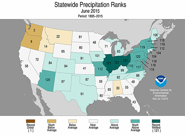
From the Midwest to the Southeast, the summer thus far has been marked by frequently sultry conditions. Dew point readings in the vicinity of 75°F have been commonplace; for a temperature of 95°F, this would correspond to a relative humidity of 53% and a heat index of 108°F. Nashville recorded a dew point of 81°F on Tuesday afternoon, its highest reading since August 1995. The moist conditions have been fostered by consistent southerly flow of near-surface air from the Gulf of Mexico, and at times by upper-level moisture streaming into the U.S. from the tropical Pacific, where El Niño continues to intensify. Some of the moisture has arrived from below, as summer heat allows water vapor to escape from wet soils left behind by record-setting rains. Both Texas and Oklahoma saw their wettest month on record in May, and Indiana, Illinois, and Ohio all saw their wettest June on record.

Figure 3. Temperature and dewpoint trace for Monday, July 13, from WU personal weather station KIAWATER4, located in Waterloo, IA. Dewpoints touched 80°F around midday.
The extremely unstable air across the Midwest this week is also a partial byproduct of agriculture. The highest U.S. dewpoints in July are often found not along the Gulf Coast but in the heart of the Corn Belt, as the enormous leaves of fast-growing corn plants send vast amounts of moisture into the air through evapotranspiration. As covered in depth by WU weather historian Chris Burt, the highest reliably measured dew point in the United States—an excruciating 90°F—was reported at Appleton, Wisconsin, on July 13, 1999 (with an air temperature of 101°F!). As farmers learn how to pack plants ever more tightly into limited space, there’s more leaf area per acre, which means more moisture pulled into the plant from deep roots can be sent back into the atmosphere. A team led by David Changnon (Northern Illinois University) published an analysis in 2003 of dewpoint increases observed at Chicago’s Midway Airport from 1928 through 2002. The authors attribute the rise to two factors: “(1) the existence of average to above-average regional precipitation anomalies occurring in May and during the [20-day] period prior to the heat event, and (2) changes in agricultural practices that have led to enhanced evapotranspiration rates in the Midwest.” A 2010 analysis by the Iowa Environmental Mesonet found that the average moisture content in the summertime atmosphere [Jun-Aug) at Des Moines increased by about 13% from 1974 to 2008, as cited in a report by Eugene Takle (Iowa State University).
We’ll have a new post by Wednesday afternoon at the latest.
Bob Henson

Figure 10. An eerie set of mammatus clouds developed over Otter Tail County, Minnesota, as a long-lived storm complex began taking shape on Sunday. Image credit: wunderphotographer spacey84.

Figure 10.. Monday’s fast-moving storm complex pushes through Indianapolis, IN, near Kuntz Stadium. Image credit: wunderphotographer mkennindy.
Figure 1. The progress of the mesoscale convective complex from Minnesota across the Midwest from late Sunday into Monday afternoon. Image credit: Greg Carbin/NOAA Storm Prediction Center.
Severe storms regenerated behind the initial MCS on Monday evening, bringing more heavy rain and high wind to parts of Illinois, Indiana, Kentucky, Ohio, and West Virginia that were struck the night before. Tennis-ball sized hail (2.5” diameter) was reported by a CoCoRaHS observer at Burnham-Wegewisch, IL (in Cook County, just southeast of Chicago), and hail close to 4” in diameter was observed near Marseilles, IL. Far west of the main action on Monday evening, a lone supercell in central Kansas produced a photogenic tornado northwest of Hutchinson (see Figure 2). By Monday evening, close to 200,000 customers had lost power as a result of the day’s storms, and flash flooding led to at least one fatality and some 150 homes damaged or destroyed in Johnson County, KY. All told, Monday produced a total of at least 477 “filtered” severe reports in the SPC database. That's the largest number on a single date since November 17, 2013, according to The Weather Channel’s Nick Wiltgen.
Yet another large MCS was making its way across southeastern Ohio on Tuesday afternoon. SPC has placed a region from eastern Kentucky and Tennessee through the Carolinas in an enhanced risk of severe weather for Tuesday afternoon and evening, with a large slight risk area covering much of the east-central U.S. and a smaller slight-risk area in western Kansas. Several dispersed areas of slight risk are in the SPC’s Day 2 outlook for Wednesday.
Figure 2. The only tornado reported with Monday’s severe weather occurred in central Kansas. Image credit: wunderphotographer rrose1. A YouTube video features a brief but spectacular clip of this tornado obtained via drone.
What’s making this summer so humid?
From the Midwest to the Southeast, the summer thus far has been marked by frequently sultry conditions. Dew point readings in the vicinity of 75°F have been commonplace; for a temperature of 95°F, this would correspond to a relative humidity of 53% and a heat index of 108°F. Nashville recorded a dew point of 81°F on Tuesday afternoon, its highest reading since August 1995. The moist conditions have been fostered by consistent southerly flow of near-surface air from the Gulf of Mexico, and at times by upper-level moisture streaming into the U.S. from the tropical Pacific, where El Niño continues to intensify. Some of the moisture has arrived from below, as summer heat allows water vapor to escape from wet soils left behind by record-setting rains. Both Texas and Oklahoma saw their wettest month on record in May, and Indiana, Illinois, and Ohio all saw their wettest June on record.
Figure 3. Temperature and dewpoint trace for Monday, July 13, from WU personal weather station KIAWATER4, located in Waterloo, IA. Dewpoints touched 80°F around midday.
The extremely unstable air across the Midwest this week is also a partial byproduct of agriculture. The highest U.S. dewpoints in July are often found not along the Gulf Coast but in the heart of the Corn Belt, as the enormous leaves of fast-growing corn plants send vast amounts of moisture into the air through evapotranspiration. As covered in depth by WU weather historian Chris Burt, the highest reliably measured dew point in the United States—an excruciating 90°F—was reported at Appleton, Wisconsin, on July 13, 1999 (with an air temperature of 101°F!). As farmers learn how to pack plants ever more tightly into limited space, there’s more leaf area per acre, which means more moisture pulled into the plant from deep roots can be sent back into the atmosphere. A team led by David Changnon (Northern Illinois University) published an analysis in 2003 of dewpoint increases observed at Chicago’s Midway Airport from 1928 through 2002. The authors attribute the rise to two factors: “(1) the existence of average to above-average regional precipitation anomalies occurring in May and during the [20-day] period prior to the heat event, and (2) changes in agricultural practices that have led to enhanced evapotranspiration rates in the Midwest.” A 2010 analysis by the Iowa Environmental Mesonet found that the average moisture content in the summertime atmosphere [Jun-Aug) at Des Moines increased by about 13% from 1974 to 2008, as cited in a report by Eugene Takle (Iowa State University).
We’ll have a new post by Wednesday afternoon at the latest.
Bob Henson
Figure 10. An eerie set of mammatus clouds developed over Otter Tail County, Minnesota, as a long-lived storm complex began taking shape on Sunday. Image credit: wunderphotographer spacey84.
Figure 10.. Monday’s fast-moving storm complex pushes through Indianapolis, IN, near Kuntz Stadium. Image credit: wunderphotographer mkennindy.
The views of the author are his/her own and do not necessarily represent the position of The Weather Company or its parent, IBM.