WunderBlog Archive » Category 6™
Category 6 has moved! See the latest from Dr. Jeff Masters and Bob Henson here.Karl and Lisa Spinning Across Atlantic; Malakas Leaves Trail of Damage in Japan
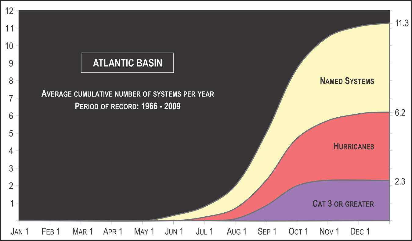
Tropical activity was ramping down in one ocean basin and ramping up in another on Tuesday morning. There were two decaying tropical storms in the Pacific--one soon to leave Japan, the other heading for Mexico’s Baja California coast--while in the Atlantic, we have two tropical storms expected to gather steam, including one just christened. The National Hurricane Center upgraded a depression in the eastern Atlantic to Tropical Storm Lisa in its 11 am EDT Tuesday advisory. Lisa is the Atlantic’s 12th tropical storm of the year, which puts us ahead of the typical number of named storms recorded in an entire Atlantic season (11.3 per year for the period 1966-2009). Though they’ve been numerous, this year’s Atlantic storms haven’t been especially strong--the seasonal accumulated cyclone energy is only about 70-75% of average for the date--or particularly long-lived. The average duration of a named storm in the Atlantic is 5 days, according to Phil Klotzbach (CSU), and Karl is only the second of this year’s 11 named storms to last even that long.

Figure 1. Infrared satellite image of Tropical Storm Lisa as of 1445Z (10:45 am EDT) Tuesday, September 20, 2016. Image credit: NOAA/NESDIS.
Outlook for Lisa
Located about 430 miles west of the Cabo Verde Islands, Lisa should be a large but fairly innocuous storm. On its northwestward path, Lisa will be rolling over modestly warm waters for development (sea surface temperatures of 27-28°C, or 81-82°F). Light wind shear today and Wednesday should allow Lisa to gather some strength. However, wind shear will be increasing sharply from Thursday onward, as shown in 12Z Tuesday output from the SHIPS statistical model. It appears unlikely Lisa will make it to hurricane strength before its surroundings turn hostile. In any event, it should continue on a northwest bearing that will allow it to recurve long before it approaches North America.

Figure 2. Latest satellite image of Tropical Storm Karl.
Karl still expected to gain strength, could threaten Bermuda
Tropical Storm Karl continues to struggle in the central Atlantic, with top sustained winds remaining a minimal 40 mph as of the 11 am EDT Tuesday advisory from NHC. Wind shear associated with a weak upper low west of Karl has been relentless in pushing shower and thunderstorm activity to the northeast, leaving Karl’s low-level center largely exposed for most of the last couple of days. Such pockets of wind shear--which can be hard to fully detect across the open Atlantic, and tough for models to portray accurately—have been quite prevalent across the Atlantic this season. It’s been one factor helping to keep storms such as eventual Hurricane Hermine from developing as rapidly as expected.
Models agree there will be enough of a weakness in the subtropical ridge so that Karl’s current westward motion will angle toward the northwest on a gradually recurving track that stays well north of the Caribbean. On this course, Karl should encounter somewhat lighter wind shear (around 10 knots), a gradually moister atmosphere (relative humidity at middle levels of the atmosphere rising from 50-55% to around 60% by late Wednesday), and progressively warmer sea surface temperatures climbing to 29-30°C (84-86°F). These ingredients will give Karl a fighting chance at gaining hurricane strength by week’s end, as predicted by NHC. Computer models are converging on a sharp turn to the northeast that would occur just in time to keep Karl from Bermuda, but it’s too soon to rule out possible impacts there. If this year’s tendency holds, Karl could achieve its maximum strength at a fairly high latitude around 30-35°N--another reason for Bermuda to pay close attention to Karl.

Figure 3. WU depiction of official NHC forecast track for Tropical Storm Karl as of 1500Z (11:00 am EDT) Tuesday, September 20, 2016.The official track takes Karl just southeast of Bermuda, but the island remains within the “cone of uncertainty.”

Figure 4. Vehicles drive through a flooded street as Typhoon Malakas moves across the city of Tokushima, located on the east end of Japan’s Shikoku Island, on Tuesday, September 20, 2016. Image credit: Jiji Press/AFP/Getty Images.
Malakas sweeps across Japan’s south coast
At least two people are missing and more than 30 were injured by the arrival of Typhoon Malakas in Japan. Malakas slammed ashore in Kyushu, the westernmost of Japan’s main islands, before churning northeast along the south coast of Shikoku and Honshu islands. Widespread torrential rain across southern Japan triggered landslides, with some wind damage reported as well. Winds gusted to 90-105 mph across much of Kyushu: Tosu City reported a gust to 43 meters per second (96 mph) just before midnight Monday night. On the east side of Kyushu, Nobeoka reported 446 mm (17.56”) of rain in 24 hours, including 407 mm (16.02”) in just 12 hours.
As of 1500Z Tuesday (midnight Tuesday night local time, or 11:00 am EDT), Malakas was located about 70 miles west of Tokyo. Now a tropical storm, Malakas is east-northeast at about 28 mph with top sustained winds down to 45 mph. It should be out to sea as a tropical depression by midday Wednesday local time. Malakas is the sixth typhoon to make landfall in Japan this year, according to JMA. That puts 2016 in a tie with 1990 and 1993 for the second-highest number of landfalling typhoons in Japan in records going back to 1951. All three years are well behind the record of 10 landfalls set in 2004.

Figure 5. Tropical Storm Paine as of 1545Z (9:45 am EDT) Tuesday, September 20, 2016. Image credit: NASA/MSFC Earth Science Office.
Paine relief: Tropical storm is decaying fast
Before long, we’ll have no more Paine to deal with (and hopefully no more Paine-ful puns). Tropical Storm Paine is weakening quickly as it moves over progressively cooler waters amid high wind shear. Paine’s top sustained winds were down to 45 mph as of the 11 am EDT Tuesday advisory, and the storm was rapidly becoming disorganized. Paine is now expected to make landfall along the northern coast of Mexico’s Baja California on Wednesday afternoon as a tropical depression. The rich moisture associated with Paine could drop several inches of rain on northern Baja California. Some of this moisture is already being entrained into a large-scale storm system moving into the western U.S., which may enhance showers and thunderstorms from the Desert Southwest on Wednesday into the central Rockies on Thursday. The first accumulating snows of the season could fall above 8000 feet across northwest Colorado and northeast Utah.
Jeff Masters and I will be back later this afternoon with a summary of global climate for August and for meteorological summer.
Bob Henson
Figure 1. Infrared satellite image of Tropical Storm Lisa as of 1445Z (10:45 am EDT) Tuesday, September 20, 2016. Image credit: NOAA/NESDIS.
Outlook for Lisa
Located about 430 miles west of the Cabo Verde Islands, Lisa should be a large but fairly innocuous storm. On its northwestward path, Lisa will be rolling over modestly warm waters for development (sea surface temperatures of 27-28°C, or 81-82°F). Light wind shear today and Wednesday should allow Lisa to gather some strength. However, wind shear will be increasing sharply from Thursday onward, as shown in 12Z Tuesday output from the SHIPS statistical model. It appears unlikely Lisa will make it to hurricane strength before its surroundings turn hostile. In any event, it should continue on a northwest bearing that will allow it to recurve long before it approaches North America.
Figure 2. Latest satellite image of Tropical Storm Karl.
Karl still expected to gain strength, could threaten Bermuda
Tropical Storm Karl continues to struggle in the central Atlantic, with top sustained winds remaining a minimal 40 mph as of the 11 am EDT Tuesday advisory from NHC. Wind shear associated with a weak upper low west of Karl has been relentless in pushing shower and thunderstorm activity to the northeast, leaving Karl’s low-level center largely exposed for most of the last couple of days. Such pockets of wind shear--which can be hard to fully detect across the open Atlantic, and tough for models to portray accurately—have been quite prevalent across the Atlantic this season. It’s been one factor helping to keep storms such as eventual Hurricane Hermine from developing as rapidly as expected.
Models agree there will be enough of a weakness in the subtropical ridge so that Karl’s current westward motion will angle toward the northwest on a gradually recurving track that stays well north of the Caribbean. On this course, Karl should encounter somewhat lighter wind shear (around 10 knots), a gradually moister atmosphere (relative humidity at middle levels of the atmosphere rising from 50-55% to around 60% by late Wednesday), and progressively warmer sea surface temperatures climbing to 29-30°C (84-86°F). These ingredients will give Karl a fighting chance at gaining hurricane strength by week’s end, as predicted by NHC. Computer models are converging on a sharp turn to the northeast that would occur just in time to keep Karl from Bermuda, but it’s too soon to rule out possible impacts there. If this year’s tendency holds, Karl could achieve its maximum strength at a fairly high latitude around 30-35°N--another reason for Bermuda to pay close attention to Karl.
Figure 3. WU depiction of official NHC forecast track for Tropical Storm Karl as of 1500Z (11:00 am EDT) Tuesday, September 20, 2016.The official track takes Karl just southeast of Bermuda, but the island remains within the “cone of uncertainty.”
Figure 4. Vehicles drive through a flooded street as Typhoon Malakas moves across the city of Tokushima, located on the east end of Japan’s Shikoku Island, on Tuesday, September 20, 2016. Image credit: Jiji Press/AFP/Getty Images.
Malakas sweeps across Japan’s south coast
At least two people are missing and more than 30 were injured by the arrival of Typhoon Malakas in Japan. Malakas slammed ashore in Kyushu, the westernmost of Japan’s main islands, before churning northeast along the south coast of Shikoku and Honshu islands. Widespread torrential rain across southern Japan triggered landslides, with some wind damage reported as well. Winds gusted to 90-105 mph across much of Kyushu: Tosu City reported a gust to 43 meters per second (96 mph) just before midnight Monday night. On the east side of Kyushu, Nobeoka reported 446 mm (17.56”) of rain in 24 hours, including 407 mm (16.02”) in just 12 hours.
As of 1500Z Tuesday (midnight Tuesday night local time, or 11:00 am EDT), Malakas was located about 70 miles west of Tokyo. Now a tropical storm, Malakas is east-northeast at about 28 mph with top sustained winds down to 45 mph. It should be out to sea as a tropical depression by midday Wednesday local time. Malakas is the sixth typhoon to make landfall in Japan this year, according to JMA. That puts 2016 in a tie with 1990 and 1993 for the second-highest number of landfalling typhoons in Japan in records going back to 1951. All three years are well behind the record of 10 landfalls set in 2004.
Figure 5. Tropical Storm Paine as of 1545Z (9:45 am EDT) Tuesday, September 20, 2016. Image credit: NASA/MSFC Earth Science Office.
Paine relief: Tropical storm is decaying fast
Before long, we’ll have no more Paine to deal with (and hopefully no more Paine-ful puns). Tropical Storm Paine is weakening quickly as it moves over progressively cooler waters amid high wind shear. Paine’s top sustained winds were down to 45 mph as of the 11 am EDT Tuesday advisory, and the storm was rapidly becoming disorganized. Paine is now expected to make landfall along the northern coast of Mexico’s Baja California on Wednesday afternoon as a tropical depression. The rich moisture associated with Paine could drop several inches of rain on northern Baja California. Some of this moisture is already being entrained into a large-scale storm system moving into the western U.S., which may enhance showers and thunderstorms from the Desert Southwest on Wednesday into the central Rockies on Thursday. The first accumulating snows of the season could fall above 8000 feet across northwest Colorado and northeast Utah.
Jeff Masters and I will be back later this afternoon with a summary of global climate for August and for meteorological summer.
Bob Henson
The views of the author are his/her own and do not necessarily represent the position of The Weather Company or its parent, IBM.