WunderBlog Archive » Category 6™
Category 6 has moved! See the latest from Dr. Jeff Masters and Bob Henson here.Is the Wait-and-See Game With 99L Ending? Also, Tornadoes Rip Indiana and Ohio
A high-stakes game of wait-and-see is underway with a large but disorganized tropical wave (Invest 99L) centered near the southeastern Bahama Islands on Thursday morning. The storm brought heavy rains of 3 - 5” over the past 24 hours to portions of the Dominican Republic and Puerto Rico, and was generating winds near tropical storm force in the waters to the north of Hispaniola. 99L could become a tropical depression or tropical storm at any time over the next three days as it heads west-northwest through The Bahamas. If 99L develops a well-defined surface circulation and tropical storm-force winds, it will be called Tropical Storm Hermine.
Satellite loops late Thursday morning showed the possibility that the game of wait-and-see may be ending. A well-defined surface circulation was attempting to form near the extreme southeastern portion of the Bahamas and Turks and Caicos Islands. However, 99L’s heavy thunderstorms were several hundred miles to the southeast of this surface swirl, and there was very little thunderstorm activity near the center. Development of heavy thunderstorms was being inhibited by high wind shear of 15 - 25 knots and dry air, as seen on water vapor satellite imagery. Sea surface temperatures (SSTs) were favorable for development, though: 29°C (84°F). An Air Force hurricane hunter aircraft was investigating 99L late Thursday morning, and at 11 am EDT found winds just below tropical storm-force--35 mph--a few hundred miles north of Hispaniola, on the east side of 99L's surface circulation.

Figure 1. Satellite image of 99L taken at 10:39 am EDT August 25, 2016. A surface circulation center was trying to form over the southeastern Bahamas and Turks and Caicos Islands.
Track forecast for 99L
A strong upper-level ridge now covering much of the Southeast U.S. and northern Gulf of Mexico will remain in place through Saturday, which should keep 99L on its general west-northwest track for the next three days. The storm will slow down from its current 15 mph forward speed to about 8 mph on Friday and Saturday, and reach the northwest Bahamas on Saturday and South Florida or the Florida Keys on Sunday. At that point, the models predict that the ridge of high pressure steering the storm will weaken, allowing 99L to turn more to the north. The timing of this turn and how far 99L might make it into the Gulf of Mexico is uncertain, though the Florida Gulf Coast is currently the area of the Gulf Coast considered to be most at risk by the models.
Intensity forecast for 99L
Since 99L is now pulling away from the high mountains of Hispaniola and is moving into an area of higher moisture and lower wind shear, the storm is likely to consolidate around the circulation center attempting to form in the southeast Bahamas. The storm should be able to develop into a tropical depression or tropical storm on Friday or Saturday. The SHIPS model predicts that wind shear will fall to the low range, 5 - 10 knots, on Friday through Sunday, and SSTs will increase to 30°C (86°F)—conditions that are very favorable for development. However, there will still be some dry air for 99L to contend with, and the storm is large, which will slow down development. The sinking air over the Western Atlantic associated with a phase of the Madden-Julian Oscillation (MJO) that is unfavorable for tropical storm development has decreased over the past two days, and it appears that the MJO will not be a factor in the intensity forecast for 99L.
Two of our three reliable models for predicting tropical genesis, the ECMWF and UKMET, continued to show development of 99L into a tropical storm by Friday in their latest 0Z Thursday (8 pm EDT Wednesday) runs. These models brought 99L across South Florida or the Florida Keys on Sunday and into the Gulf of Mexico, with a second landfall occurring on the Florida Gulf Coast on Tuesday. Our other reliable tropical cyclone genesis model, the GFS, continued to insist that 99L would not develop through Sunday. The initial track forecast for 99L in this morning’s run of the GFS was too close to the coast of Hispaniola compared to the European model’s track, so I think the European’s model’s forecast will be superior to the GFS forecast. In their 8 am EDT Wednesday Tropical Weather Outlook, NHC gave 99L 2-day and 5-day development odds of 50% and 80%, respectively. Unfortunately, we don’t have much skill forecasting rapid intensification, but the possibility exists that 99L could undergo a period of rapid intensification in the 24 hours before landfall in South Florida and arrive there as a Category 1 hurricane on Sunday. However, it is more likely that South Florida will experience a tropical storm. If the storm manages to spend an extra day of two over the warm waters of the Gulf of Mexico on Monday and Tuesday, 99L will have additional time to organize and intensify, and there is a greater chance it will be a hurricane for its second potential landfall on Tuesday.
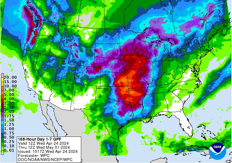
Regardless of whether or not 99L ever becomes Tropical Storm Hermine, Florida is going to get a lot of rain from this system. The 7-day precipitation outlook from NOAA’s Weather Prediction Center (WPC) calls for a large area of 5” - 8” rains across southern and western Florida over the next week. Such rains could put stress on the 80-year-old dike that protects thousands of residents near Lake Okeechobee, as I discussed in a special post yesterday.

Figure 2. The twister that produced widespread damage in Kokomo, IN, was captured in this still image drawn from a video. Image credit: Bruce Robinson via AP.
Localized tornado outbreak pummels Indiana, Ohio
An afternoon of garden-variety Midwest thunderstorms morphed into an Wednesday-evening swarm of tornadoes that surprised residents and forecasters alike. As of Thursday morning, NOAA’s Storm Prediction Center (SPC) had tallied 35 tornado reports in Indiana and Ohio from 12Z (8:00 am EDT) Wednesday through 12Z Thursday. Most of these were associated with two powerful supercell thunderstorms that traveled from northern Indiana into northwest Ohio. Data from survey teams that were canvassing the region on Thursday will help nail down how many independent damage swaths were produced by the two apparent tornado “families”. The NWS/Indianapolis office will be posting images and information at a dedicated website.
Hardest-hit was the Kokomo area, about 60 miles north of Indianapolis, which was struck at the beginning of the outbreak just after 3:00 pm EDT Wednesday. The NWS confirmed EF3 damage in Kokomo, according to weather.com. Dozens of homes and businesses were damaged, and a Starbucks shop was flattened in dramatic fashion, as captured on the video embedded at bottom. People inside the Starbucks were not seriously hurt, as they had taken shelter within a bathroom. Amazingly, despite the widespread damage, only minor injuries had been reported in Kokomo as of Wednesday morning. Subsequent tornadoes produced far-flung but non-catastrophic damage for the next five hours, with the final twister in the mini-outbreak occurring around 8:00 pm EDT near Gallup, OH, more than 100 miles east-northeast of Kokomo.

Figure 3. A vehicle rests on another after a tornado struck in Kokomo, IN, on Wednesday, August, 24, 2016. Multiple tornadoes touched down in Indiana on Wednesday, tearing the roofs off apartment buildings, sending air conditioners falling onto parked cars, and cutting power to thousands of people. Image credit: TeeJay Crawford via AP.
What happened—and why?
Severe weather researchers are already puzzling over Wednesday’s event, which did not present itself earlier in the day as a classic set-up for tornadoes. Humid, unstable air was located over southern Indiana and Ohio, but this is a common occurrence across the Midwest in August. Cloudier, more stable conditions prevailed toward the north, and the resulting boundary appears to have served as a focal point for the day’s severe storms. NOAA/SPC had flagged northern Indiana and Ohio with only a marginal risk of severe weather earlier in the day, with less than a 2% chance of tornadoes. However, nearly all of the tornadoes were captured by SPC tornado watches, including one issued just a few minutes before Kokomo was struck, and the tornadoes themselves received ample warning from local NWS offices.
The biggest surprise is the lack of robust upper-level support for the tornadic storms. Paul Markowski (Pennsylvania State University) found only a modest amount of deep vertical wind shear in the closest upper-air soundings collected at 8:00 pm EDT Wednesday from Wilmington, OH, and Detroit, MI. Although vertical wind shear through the lowest few miles of the atmosphere is destructive to hurricanes, it helps support the asymmetric structure of tornadic supercells. However, the Wilmington and Detroit soundings did show strong low-level wind shear (between the surface and about 3000 feet). In addition, high relative humidities near the surface meant that the bases of the supercell storms were quite low, which would have enhanced rising motion in the vicinity of the low-level shear—a boon for tornado development.
Bob Henson (tornado portion) and Jeff Masters (99L portion)
Video 1. The exterior of a Starbucks shop is destroyed by tornadic winds as videotaped from an adjacent business. Patrons at the Starbucks had taken shelter in the store’s bathroom, and none were hurt seriously.
Satellite loops late Thursday morning showed the possibility that the game of wait-and-see may be ending. A well-defined surface circulation was attempting to form near the extreme southeastern portion of the Bahamas and Turks and Caicos Islands. However, 99L’s heavy thunderstorms were several hundred miles to the southeast of this surface swirl, and there was very little thunderstorm activity near the center. Development of heavy thunderstorms was being inhibited by high wind shear of 15 - 25 knots and dry air, as seen on water vapor satellite imagery. Sea surface temperatures (SSTs) were favorable for development, though: 29°C (84°F). An Air Force hurricane hunter aircraft was investigating 99L late Thursday morning, and at 11 am EDT found winds just below tropical storm-force--35 mph--a few hundred miles north of Hispaniola, on the east side of 99L's surface circulation.
Figure 1. Satellite image of 99L taken at 10:39 am EDT August 25, 2016. A surface circulation center was trying to form over the southeastern Bahamas and Turks and Caicos Islands.
Track forecast for 99L
A strong upper-level ridge now covering much of the Southeast U.S. and northern Gulf of Mexico will remain in place through Saturday, which should keep 99L on its general west-northwest track for the next three days. The storm will slow down from its current 15 mph forward speed to about 8 mph on Friday and Saturday, and reach the northwest Bahamas on Saturday and South Florida or the Florida Keys on Sunday. At that point, the models predict that the ridge of high pressure steering the storm will weaken, allowing 99L to turn more to the north. The timing of this turn and how far 99L might make it into the Gulf of Mexico is uncertain, though the Florida Gulf Coast is currently the area of the Gulf Coast considered to be most at risk by the models.
Intensity forecast for 99L
Since 99L is now pulling away from the high mountains of Hispaniola and is moving into an area of higher moisture and lower wind shear, the storm is likely to consolidate around the circulation center attempting to form in the southeast Bahamas. The storm should be able to develop into a tropical depression or tropical storm on Friday or Saturday. The SHIPS model predicts that wind shear will fall to the low range, 5 - 10 knots, on Friday through Sunday, and SSTs will increase to 30°C (86°F)—conditions that are very favorable for development. However, there will still be some dry air for 99L to contend with, and the storm is large, which will slow down development. The sinking air over the Western Atlantic associated with a phase of the Madden-Julian Oscillation (MJO) that is unfavorable for tropical storm development has decreased over the past two days, and it appears that the MJO will not be a factor in the intensity forecast for 99L.
Two of our three reliable models for predicting tropical genesis, the ECMWF and UKMET, continued to show development of 99L into a tropical storm by Friday in their latest 0Z Thursday (8 pm EDT Wednesday) runs. These models brought 99L across South Florida or the Florida Keys on Sunday and into the Gulf of Mexico, with a second landfall occurring on the Florida Gulf Coast on Tuesday. Our other reliable tropical cyclone genesis model, the GFS, continued to insist that 99L would not develop through Sunday. The initial track forecast for 99L in this morning’s run of the GFS was too close to the coast of Hispaniola compared to the European model’s track, so I think the European’s model’s forecast will be superior to the GFS forecast. In their 8 am EDT Wednesday Tropical Weather Outlook, NHC gave 99L 2-day and 5-day development odds of 50% and 80%, respectively. Unfortunately, we don’t have much skill forecasting rapid intensification, but the possibility exists that 99L could undergo a period of rapid intensification in the 24 hours before landfall in South Florida and arrive there as a Category 1 hurricane on Sunday. However, it is more likely that South Florida will experience a tropical storm. If the storm manages to spend an extra day of two over the warm waters of the Gulf of Mexico on Monday and Tuesday, 99L will have additional time to organize and intensify, and there is a greater chance it will be a hurricane for its second potential landfall on Tuesday.
Regardless of whether or not 99L ever becomes Tropical Storm Hermine, Florida is going to get a lot of rain from this system. The 7-day precipitation outlook from NOAA’s Weather Prediction Center (WPC) calls for a large area of 5” - 8” rains across southern and western Florida over the next week. Such rains could put stress on the 80-year-old dike that protects thousands of residents near Lake Okeechobee, as I discussed in a special post yesterday.
Figure 2. The twister that produced widespread damage in Kokomo, IN, was captured in this still image drawn from a video. Image credit: Bruce Robinson via AP.
Localized tornado outbreak pummels Indiana, Ohio
An afternoon of garden-variety Midwest thunderstorms morphed into an Wednesday-evening swarm of tornadoes that surprised residents and forecasters alike. As of Thursday morning, NOAA’s Storm Prediction Center (SPC) had tallied 35 tornado reports in Indiana and Ohio from 12Z (8:00 am EDT) Wednesday through 12Z Thursday. Most of these were associated with two powerful supercell thunderstorms that traveled from northern Indiana into northwest Ohio. Data from survey teams that were canvassing the region on Thursday will help nail down how many independent damage swaths were produced by the two apparent tornado “families”. The NWS/Indianapolis office will be posting images and information at a dedicated website.
Hardest-hit was the Kokomo area, about 60 miles north of Indianapolis, which was struck at the beginning of the outbreak just after 3:00 pm EDT Wednesday. The NWS confirmed EF3 damage in Kokomo, according to weather.com. Dozens of homes and businesses were damaged, and a Starbucks shop was flattened in dramatic fashion, as captured on the video embedded at bottom. People inside the Starbucks were not seriously hurt, as they had taken shelter within a bathroom. Amazingly, despite the widespread damage, only minor injuries had been reported in Kokomo as of Wednesday morning. Subsequent tornadoes produced far-flung but non-catastrophic damage for the next five hours, with the final twister in the mini-outbreak occurring around 8:00 pm EDT near Gallup, OH, more than 100 miles east-northeast of Kokomo.
Figure 3. A vehicle rests on another after a tornado struck in Kokomo, IN, on Wednesday, August, 24, 2016. Multiple tornadoes touched down in Indiana on Wednesday, tearing the roofs off apartment buildings, sending air conditioners falling onto parked cars, and cutting power to thousands of people. Image credit: TeeJay Crawford via AP.
What happened—and why?
Severe weather researchers are already puzzling over Wednesday’s event, which did not present itself earlier in the day as a classic set-up for tornadoes. Humid, unstable air was located over southern Indiana and Ohio, but this is a common occurrence across the Midwest in August. Cloudier, more stable conditions prevailed toward the north, and the resulting boundary appears to have served as a focal point for the day’s severe storms. NOAA/SPC had flagged northern Indiana and Ohio with only a marginal risk of severe weather earlier in the day, with less than a 2% chance of tornadoes. However, nearly all of the tornadoes were captured by SPC tornado watches, including one issued just a few minutes before Kokomo was struck, and the tornadoes themselves received ample warning from local NWS offices.
The biggest surprise is the lack of robust upper-level support for the tornadic storms. Paul Markowski (Pennsylvania State University) found only a modest amount of deep vertical wind shear in the closest upper-air soundings collected at 8:00 pm EDT Wednesday from Wilmington, OH, and Detroit, MI. Although vertical wind shear through the lowest few miles of the atmosphere is destructive to hurricanes, it helps support the asymmetric structure of tornadic supercells. However, the Wilmington and Detroit soundings did show strong low-level wind shear (between the surface and about 3000 feet). In addition, high relative humidities near the surface meant that the bases of the supercell storms were quite low, which would have enhanced rising motion in the vicinity of the low-level shear—a boon for tornado development.
Bob Henson (tornado portion) and Jeff Masters (99L portion)
WATCH: Video shows an entire Starbucks building collapse and flatten as a tornado moves through Kokomo, Indiana.https://t.co/vFYvxqWZR1
— NBC Nightly News (@NBCNightlyNews) August 24, 2016
Video 1. The exterior of a Starbucks shop is destroyed by tornadic winds as videotaped from an adjacent business. Patrons at the Starbucks had taken shelter in the store’s bathroom, and none were hurt seriously.
The views of the author are his/her own and do not necessarily represent the position of The Weather Company or its parent, IBM.