WunderBlog Archive » Category 6™
Category 6 has moved! See the latest from Dr. Jeff Masters and Bob Henson here.Half way there
We're half way there. That's right, today is September 10, and that marks the half way point of hurricane season in the Atlantic. On average, half of all hurricanes and tropical storms occur after September 10. We still have a long way to go in what has already been the most destructive hurricane season on record.
What does the second half of hurricane season have in store for us? Well, after Ophelia departs, there is nothing brewing to take her place. The entire tropical Atlantic between Africa and the Lesser Antilles is covered with dry, dust-laden Saharan air that should suppress hurricane activity there. However, according to the September 2nd forecast issued by Dr. Bill Gray of Colorado State, tropical cyclone activity for the remainer of this hurricane season will be over 50% above average. The September-only forecast calls for five named storms and four hurricanes, with two of them major hurricanes. The October-only forecast calls for three named storms and two hurricanes with one of them a major hurricane. Normal activity for September-October is five named storms and 3.5 hurricanes, with one or two of them a major hurricane. So if you live on the coast, stock up on your hurricane supplies, review your evacuation options, and hang on for the second half of this unbelievable hurricane season of 2005.
Ophelia weakened to a tropical storm last night as the trough carrying it northeastward dumped dry air into her northwest side and attacked the west side with 20 knots of shearing winds. The trough has moved ahead of Ophelia this morning, and she is now slowing down and strengthening in response. The shear has fallen back to the 10 - 15 knots she has lived with most of her life, and the dry air is starting to mix out. The 10am EDT Air Force hurricane hunter flight found Ophelia's lowest pressure and strongest winds yet, 976 mb and 80 mph, repsectively. Long range radar out of Wilmington, NC is showing little change in what it can see of the northwestern portion of the storm, and little motion of the center.
Track forecast
Most of the major computer models show a track into South Carolina by Tuesday. The exceptions are the Canadian model, which calls for a Georgia landfall, and the NOGAPS model, which stalls Ophelia offshore for the next five days until finally bring her across Cape Hatteras, North Carolina on Friday. The official NHC forecast follows the consensus, bringing Ophelia ashore near Charleston, SC on Tuesday. The official NHC forecast has outperformed all the computer models so far for this storm, but keep in mind that the median track error for the NHC 3-day forecasts is about 230 miles, meaning that half of the time, the forecast is worse than that. All residents of the Georgia, South Carolina, and North Carolina coasts need to be prepared for what will most likely be a Category 1 or 2 hurricane, but could be a Category 3.
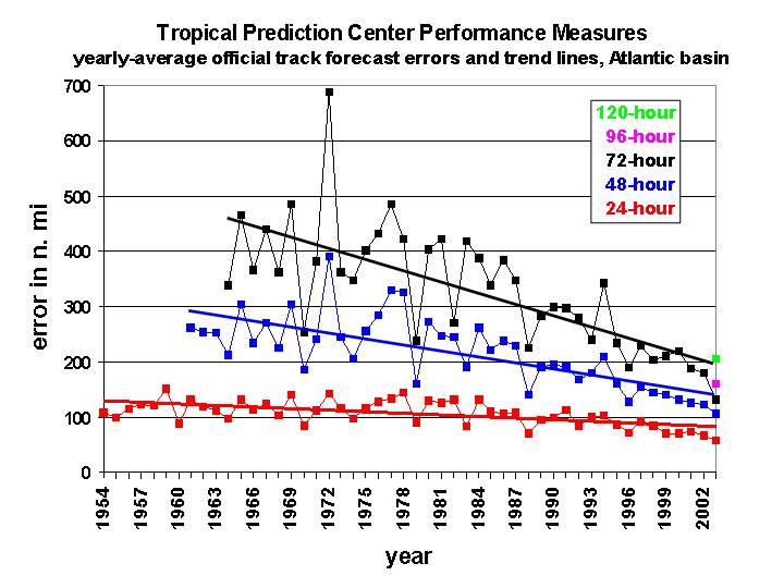
Figure 1. Average track error of official National Hurricane Center Forecasts (in nautical miles, multiply by 1.15 get get the result in miles). Image credit: Dr. Chris Landsea, NOAA/AOML Hurricane Research Division.
Intensity forecast
Shearing winds are expected to continue to affect Ophelia the next three days, limiting the amount of intensification that will occur. This shear will come from upper-level winds out of the west to southwest. Satellite images clearly show the effect of this shear on the hurricane--the southwest side of the storm has much reduced cloud coverage. On the plus side for the Ophelia, the counter-clockwise flow around an upper-level low to her southeast is beginning to provide an outflow channel to the south, something Ophelia has lacked her entire life. This improving outflow to the south is likely a big part of the reason for her return to hurricane strength today.
The computer models differ on how all these factors will affect Ophelia's intensity. The SHIPS model keeps her just below hurricane strength for the next three days, while the GFDL intensifies her to a Category 3 hurricane. The official NHC forecast calls for a strong Category 1 hurricane at landfall. I believe that given this storm's proven resiliency to shear, plus the opening of a new outflow channel to the south, Ophelia's intensity three days from now should be at least Category 2 and possibly Category 3. A stronger storm than that would be a major surprise.
Dr. Jeff Masters
What does the second half of hurricane season have in store for us? Well, after Ophelia departs, there is nothing brewing to take her place. The entire tropical Atlantic between Africa and the Lesser Antilles is covered with dry, dust-laden Saharan air that should suppress hurricane activity there. However, according to the September 2nd forecast issued by Dr. Bill Gray of Colorado State, tropical cyclone activity for the remainer of this hurricane season will be over 50% above average. The September-only forecast calls for five named storms and four hurricanes, with two of them major hurricanes. The October-only forecast calls for three named storms and two hurricanes with one of them a major hurricane. Normal activity for September-October is five named storms and 3.5 hurricanes, with one or two of them a major hurricane. So if you live on the coast, stock up on your hurricane supplies, review your evacuation options, and hang on for the second half of this unbelievable hurricane season of 2005.
Ophelia weakened to a tropical storm last night as the trough carrying it northeastward dumped dry air into her northwest side and attacked the west side with 20 knots of shearing winds. The trough has moved ahead of Ophelia this morning, and she is now slowing down and strengthening in response. The shear has fallen back to the 10 - 15 knots she has lived with most of her life, and the dry air is starting to mix out. The 10am EDT Air Force hurricane hunter flight found Ophelia's lowest pressure and strongest winds yet, 976 mb and 80 mph, repsectively. Long range radar out of Wilmington, NC is showing little change in what it can see of the northwestern portion of the storm, and little motion of the center.
Track forecast
Most of the major computer models show a track into South Carolina by Tuesday. The exceptions are the Canadian model, which calls for a Georgia landfall, and the NOGAPS model, which stalls Ophelia offshore for the next five days until finally bring her across Cape Hatteras, North Carolina on Friday. The official NHC forecast follows the consensus, bringing Ophelia ashore near Charleston, SC on Tuesday. The official NHC forecast has outperformed all the computer models so far for this storm, but keep in mind that the median track error for the NHC 3-day forecasts is about 230 miles, meaning that half of the time, the forecast is worse than that. All residents of the Georgia, South Carolina, and North Carolina coasts need to be prepared for what will most likely be a Category 1 or 2 hurricane, but could be a Category 3.
Figure 1. Average track error of official National Hurricane Center Forecasts (in nautical miles, multiply by 1.15 get get the result in miles). Image credit: Dr. Chris Landsea, NOAA/AOML Hurricane Research Division.
Intensity forecast
Shearing winds are expected to continue to affect Ophelia the next three days, limiting the amount of intensification that will occur. This shear will come from upper-level winds out of the west to southwest. Satellite images clearly show the effect of this shear on the hurricane--the southwest side of the storm has much reduced cloud coverage. On the plus side for the Ophelia, the counter-clockwise flow around an upper-level low to her southeast is beginning to provide an outflow channel to the south, something Ophelia has lacked her entire life. This improving outflow to the south is likely a big part of the reason for her return to hurricane strength today.
The computer models differ on how all these factors will affect Ophelia's intensity. The SHIPS model keeps her just below hurricane strength for the next three days, while the GFDL intensifies her to a Category 3 hurricane. The official NHC forecast calls for a strong Category 1 hurricane at landfall. I believe that given this storm's proven resiliency to shear, plus the opening of a new outflow channel to the south, Ophelia's intensity three days from now should be at least Category 2 and possibly Category 3. A stronger storm than that would be a major surprise.
Dr. Jeff Masters
The views of the author are his/her own and do not necessarily represent the position of The Weather Company or its parent, IBM.