WunderBlog Archive » Category 6™
Category 6 has moved! See the latest from Dr. Jeff Masters and Bob Henson here.Gulf of Mexico disturbance may develop; Chris a hurricane; record Duluth flooding
An area of low pressure and heavy thunderstorms entering the Southern Gulf of Mexico is bringing sporadic heavy rains to Western Cuba and Mexico's Yucatan Peninsula, and winds of 20 - 25 mph to surrounding ocean areas. This disturbance will need to be watched for development as it drifts slowly northward at about 5 mph into the Central Gulf of Mexico by Saturday. The disturbance is poorly organized, and has only a modest area of heavy thunderstorms. Wind shear is a moderate to high 15 - 25 knots over the region. Ocean temperatures are 81 - 83°F in the Western Caribbean and Southern Gulf of Mexico, which is about 1°F above average, and plenty warm to support formation of a tropical storm.

Figure 1. Morning satellite image of the tropical disturbance entering the Southern Gulf of Mexico.
Forecast for Gulf of Mexico disturbance
Wind shear is predicted to remain in the moderate to high range through Friday. Water vapor satellite loops show a region of dry air over the Northern Gulf of Mexico; this dry air is probably too far away to significantly interfere with development. I expect we will see an increase in the disturbance's heavy thunderstorm activity today as a result of less interference from dry air. By Saturday, our two top models, the European model (ECMWF) and GFS, predict that wind shear could fall to the moderate range, 10 - 20 knots, which would potentially allow the disturbance to approach tropical depression status by Sunday. A trough of low pressure pushing off of the U.S. East Coast will be capable of grabbing the disturbance and accelerating it to the northeast on Sunday, as predicted by the GFS model, which takes the disturbance across Florida on Sunday, and into the waters off the coast of South Carolina by Monday. The GFS does not develop the disturbance while it is in the Gulf of Mexico, but suggests it could develop into a tropical or subtropical depression off the coast of South Carolina Monday or Tuesday. The latest ECMWF model run (00 UTC) predicts that this through will not be strong enough to pull the disturbance northeastwards across Florida, and the disturbance will instead linger in the Gulf of Mexico for many days, giving it time to develop into a tropical depression next week. The UKMET and NOGAPS models predict a more westward drift, with the disturbance affecting the Mexico/Texas border region 6 - 7 days from now. At this point, we can't rule out any location in the Gulf being affected by this system, though the Gulf coast of Florida has the highest probability of seeing impacts. NHC is giving the disturbance a 30% chance of developing into a tropical depression by Saturday morning. This is a reasonable forecast, and the odds will probably rise by Friday, and I give the disturbance a 50% chance of developing into a tropical depression by Monday morning.

Figure 2. Morning satellite image of Hurricane Chris.
Chris reaches hurricane strength; not a threat to land
Hurricane Chris has managed to intensify and form an eye-like feature surrounded by intense thunderstorms with very cold tops, despite the fact the storm is over cool waters of 22°C. NHC puts Chris at hurricane strength with 75 mph winds making it the first hurricane of the 2012 hurricane season. Chris attained hurricane strength unusually far to the north (41.1°N) for a June storm; only Hurricane One of 1893 was a June hurricane at a more northernly point (44°N) than Chris. Chris is headed northeastwards, out to sea, and will not trouble any land areas. Only twice before, in 1887 and 1959, has the third storm of the season formed earlier than June 20. Formation of three tropical storms so early in the year is not necessarily a harbinger of an active season; 1959 was close to average, with 12 named storms, 7 hurricanes, and 2 intense hurricanes (average is 11 named storms, 6 hurricanes, and 2 intense hurricanes.) Unusual levels of early season activity in the Caribbean and between Africa and the Lesser Antilles usually portends a very active hurricane season, but this year's storms have not formed in this region. Alberto, Beryl, and Chris all formed off the U.S. East Coast.

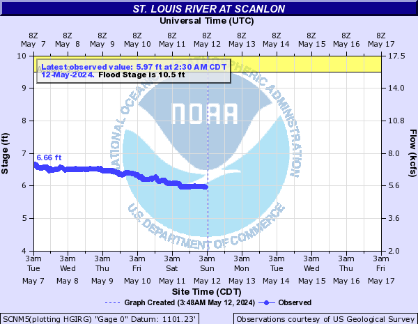
Figure 3. The St. Louis river upstream from Duluth, Minnesota reached its highest flood height on record this morning, 6.1' above flood stage. The river rose over ten feet in 24 hours. Image credit: NOAA.
Record flooding in Duluth, Minnesota
Flood waters have crested in Duluth, Minnesota this Thursday morning, and are slowly falling, in the wake of the city's all-time record 24-hour rainstorm. A series of "training" thunderstorms that followed the same path passed over a wide swath of Northern Minnesota between noon Tuesday and noon Wednesday, dropping 7.20" of rain on the city. According to wunderground's weather historian Christopher C. Burt, this far surpasses the previous 24-hour record rainfall for Duluth, the 5.79" that fell on August 22 - 23, 1978. Two rivers in the Duluth area, the Nemadji and St. Louis, hit their highest flood heights on record Thursday morning, causing destructive flooding. Sadly, major flooding occurred at the Duluth zoo, washing a seal into a neighboring street, and killing at least eleven zoo animals.
Jeff Masters
Figure 1. Morning satellite image of the tropical disturbance entering the Southern Gulf of Mexico.
Forecast for Gulf of Mexico disturbance
Wind shear is predicted to remain in the moderate to high range through Friday. Water vapor satellite loops show a region of dry air over the Northern Gulf of Mexico; this dry air is probably too far away to significantly interfere with development. I expect we will see an increase in the disturbance's heavy thunderstorm activity today as a result of less interference from dry air. By Saturday, our two top models, the European model (ECMWF) and GFS, predict that wind shear could fall to the moderate range, 10 - 20 knots, which would potentially allow the disturbance to approach tropical depression status by Sunday. A trough of low pressure pushing off of the U.S. East Coast will be capable of grabbing the disturbance and accelerating it to the northeast on Sunday, as predicted by the GFS model, which takes the disturbance across Florida on Sunday, and into the waters off the coast of South Carolina by Monday. The GFS does not develop the disturbance while it is in the Gulf of Mexico, but suggests it could develop into a tropical or subtropical depression off the coast of South Carolina Monday or Tuesday. The latest ECMWF model run (00 UTC) predicts that this through will not be strong enough to pull the disturbance northeastwards across Florida, and the disturbance will instead linger in the Gulf of Mexico for many days, giving it time to develop into a tropical depression next week. The UKMET and NOGAPS models predict a more westward drift, with the disturbance affecting the Mexico/Texas border region 6 - 7 days from now. At this point, we can't rule out any location in the Gulf being affected by this system, though the Gulf coast of Florida has the highest probability of seeing impacts. NHC is giving the disturbance a 30% chance of developing into a tropical depression by Saturday morning. This is a reasonable forecast, and the odds will probably rise by Friday, and I give the disturbance a 50% chance of developing into a tropical depression by Monday morning.
Figure 2. Morning satellite image of Hurricane Chris.
Chris reaches hurricane strength; not a threat to land
Hurricane Chris has managed to intensify and form an eye-like feature surrounded by intense thunderstorms with very cold tops, despite the fact the storm is over cool waters of 22°C. NHC puts Chris at hurricane strength with 75 mph winds making it the first hurricane of the 2012 hurricane season. Chris attained hurricane strength unusually far to the north (41.1°N) for a June storm; only Hurricane One of 1893 was a June hurricane at a more northernly point (44°N) than Chris. Chris is headed northeastwards, out to sea, and will not trouble any land areas. Only twice before, in 1887 and 1959, has the third storm of the season formed earlier than June 20. Formation of three tropical storms so early in the year is not necessarily a harbinger of an active season; 1959 was close to average, with 12 named storms, 7 hurricanes, and 2 intense hurricanes (average is 11 named storms, 6 hurricanes, and 2 intense hurricanes.) Unusual levels of early season activity in the Caribbean and between Africa and the Lesser Antilles usually portends a very active hurricane season, but this year's storms have not formed in this region. Alberto, Beryl, and Chris all formed off the U.S. East Coast.
Figure 3. The St. Louis river upstream from Duluth, Minnesota reached its highest flood height on record this morning, 6.1' above flood stage. The river rose over ten feet in 24 hours. Image credit: NOAA.
Record flooding in Duluth, Minnesota
Flood waters have crested in Duluth, Minnesota this Thursday morning, and are slowly falling, in the wake of the city's all-time record 24-hour rainstorm. A series of "training" thunderstorms that followed the same path passed over a wide swath of Northern Minnesota between noon Tuesday and noon Wednesday, dropping 7.20" of rain on the city. According to wunderground's weather historian Christopher C. Burt, this far surpasses the previous 24-hour record rainfall for Duluth, the 5.79" that fell on August 22 - 23, 1978. Two rivers in the Duluth area, the Nemadji and St. Louis, hit their highest flood heights on record Thursday morning, causing destructive flooding. Sadly, major flooding occurred at the Duluth zoo, washing a seal into a neighboring street, and killing at least eleven zoo animals.
Jeff Masters
The views of the author are his/her own and do not necessarily represent the position of The Weather Company or its parent, IBM.