WunderBlog Archive » Category 6™
Category 6 has moved! See the latest from Dr. Jeff Masters and Bob Henson here.Earth Headed For its Hottest Year on Record After a Record-Warm September
September 2014 was Earth's warmest September on record, the period January - September was tied with 1998 and 2010 as the warmest first three-quarters of any year on record, and the past 12 months--October 2013 through September 2014--was the warmest consecutive 12-month period among all months since records began in 1880, said NOAA's National Climatic Data Center (NCDC) today. NASA also rated September 2014 as the warmest September on record. If 2014 maintains the same temperature departure from average for the remainder of the year as was observed during January - September, it will be the warmest calendar year on record. September is the fourth time NOAA has ranked a 2014 month as the warmest on record; May, June, and August 2014 were also the warmest such months on record. (April 2014 was originally ranked as tied for warmest April on record, but has since been revised downwards to the second warmest April on record.) Global ocean temperatures during September 2014 were the warmest on record, and the 0.66°C (1.19°F) ocean temperature anomaly was the highest ever measured, beating the record set just the month previously in August 2014. Global land temperatures in September 2014 were the 6th warmest on record. Global satellite-measured temperatures in September 2014 for the lowest 8 km of the atmosphere were the 14th or 7th warmest in the 36-year record, according to Remote Sensing Systems and the University of Alabama Huntsville (UAH), respectively. Wunderground's weather historian, Christopher C. Burt, has a summary of September 2014's extreme weather.

Figure 1. Departure of temperature from average for September 2014, the warmest September for the globe since record keeping began in 1880. Record warmth was notable in much of northwestern Africa, coastal regions of southeastern South America, southwestern Australia, parts of the Middle East, and regions of southeastern Asia. In total, 31 countries and territories from all seven continents around the world had at least one station that reported record warmth. Cooler than average temperatures were uncommon world-wide. Image credit: National Climatic Data Center (NCDC) .

Four billion-dollar weather disasters in September 2014
Four billion-dollar weather-related disasters hit the Earth during September 2014, according to the September 2014 Catastrophe Report from insurance broker Aon Benfield. This brings the global number of billion-dollar weather disasters for the first eight months of 2014 to 21. This is well behind the record-setting pace of 2013, which had 33 billion-dollar weather disasters by the end of September, and ended up with a record 41 by the end of the year. Here are September 2014's billion-dollar weather disasters:

Disaster 1. Torrential monsoon rains of over 12" (305 mm) lashed the India-Pakistan border region of Kashmir and Jammu Provinces on September 3 - 7, triggering devastating floods that swept through the mountainous region, killing at least 648 people and doing $18+ billion in damage. Hardest-hit were India's Jammu and Kashmir region, where damages were estimated at $16+ billion. According to EM-DAT, the International Disaster Database, this is the most expensive natural disaster in India's history, surpassing the $11.6 billion price tag (2014 dollars) of the July 1993 monsoon floods. In Pakistan, at least 207 people died and damage was estimated at $2 billion. Crippling and catastrophic floods have become the new normal in Pakistan, where the six most expensive floods in their history have come in the past eight years--2010, 2011, 2012, 2014, 2007, and 2013. In this image, we see Kashmiri residents struggling to withstand sudden and strong water currents while wading through floodwaters in their efforts to move to safer places in Srinagar, India, Thursday, Sept. 4, 2014. (AP Photo/Dar Yasin)

Disaster 2. Typhoon Kalmaegi hit the Philippines, China, and Vietnam between September 10 - 16, killing at least 31 and doing $3 billion in damage. The typhoon's first landfall, as a Category 1 storm, came in the Philippines’ Luzon Island, where 12 people were killed and at least 1,500 homes damaged, with damages estimated at $14 million. Kalmaegi killed nine people in China and did $2.9 billion in damage. In Vietnam, ten people were killed across northern sections of the country, and damages were estimated at $4.5 million. In this image, we see Kalmaegi as it swirled to the south of the island of Taiwan at night, as seen from the International Space Station by astronaut Reid Wiseman (@astro_reid) at 3 pm EDT September 14, 2014. At the time, Kalmaegi had just crossed the Philippines' Luzon Island as a Category 1 typhoon, and had weakened to a tropical storm with 70 mph winds. Hong Kong is the other bright patch of lights. Image credit: Reid Wiswman.

Disaster 3. Hurricane Odile made landfall near Cabo San Lucas, Mexico on September 15, 2014, as a Category 3 storm with 125 mph winds. Odile was the strongest storm on record to hit Mexico’s Baja California Peninsula, and killed five people and injured 135. Tens of thousands of homes, structures and vehicles were damaged or destroyed by Odile’s high winds and flooding rains, and total damage was estimated at $2 - $4 billion. This is a MODIS satellite image of Hurricane Odile off the coast of Mexico's Baja Peninsula, taken at approximately 2 pm EDT Sunday September 14, 2014. At the time, Odile was a Category 3 storm with 125 mph winds. Image credit: NASA.

Disaster 4. Torrential rains in southwestern China on September 10 - 17 killed 50 and did $1.4 billion in damage. In this VIIRS satellite image from September 16, 2014, we see Typhoon Kalmaegi hitting southeast China at the same time as torrential rains from unrelated thunderstorms are affecting southwest China. Image credit: NOAA Visualization Lab.
An El Niño Watch continues
September 2014 featured neutral El Niño conditions in the equatorial Eastern Pacific, and sea surface temperatures were about 0.3°C above average in September in the so-called Niño 3.4 region (5°S - 5°N, 120°W - 170°W), where SSTs must be at least 0.5°C above average for five consecutive months for an El Niño event to be declared. NOAA is continuing its El Niño Watch, and is giving a 2-in-3 chance of an El Niño developing this winter.
Arctic sea ice falls to 6th lowest September extent on record
Arctic sea ice extent during September 2014 was the 6th lowest in the 36-year satellite record and was similar to September 2013 levels, according to the National Snow and Ice Data Center (NSIDC). On September 17th, the Artic sea ice extent reached its annual minimum, two days later than average. The Northern Sea Route (also known as the Northeast Passage)--the shipping lane along the north coast of Russia in Arctic waters--was open for over a month in 2014, according to ice edge analyses by the National Snow and Ice Data Center and the University of Illinois Cryosphere Today. The Northwest Passage through the Arctic waters of Canada did not open in 2014. Mariners have been attempting to sail these passages since 1497. The Northeast Passage opened to ice-free navigation for the first time in recorded history in 2005, with the Northwest Passage following suit during the summer of 2007. Both passages have been open multiple summers since then, as long-term melting of the ice has continued. However, this summer's weather in the Arctic featured winds favorable for not letting sea ice drift out through Fram Strait, and we have seen the total volume of sea sea as estimated by the University of Washington PIOMAS model pull back from the record low set in 2012. Some of the 2nd-year ice that survived the summer of 2013 has also survived the summer of 2014, so the ice pack is armoring itself a bit going into 2015 with a modest amount of multi-year ice compared to what we went into 2012 with (2012 set the record for lowest Arctic sea ice extent.)
Most spectacular weather videos of September
Video 1. Torrential rains in Serbia caused flash floods that killed one person and swept way cars, as seen in this video.
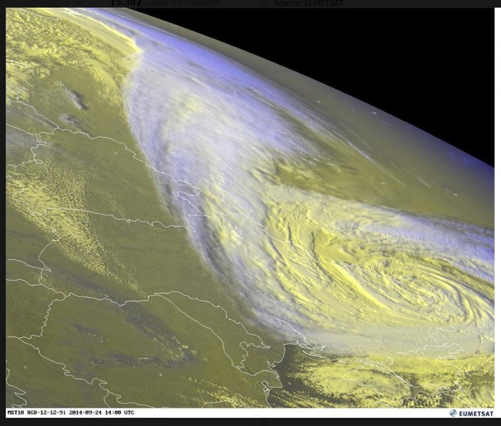
Video 2. A remarkable storm surge with high waves sweeps vehicles away along the northeastern coast of Turkey on the Black Sea on September 24, 2014. The surge was caused by a large 990 mb low; underground member barbamz saved a satellite image of the storm here.
Video 3. Spectacular sunset, aurora, and sunrise from the top of Mt. Washington, New Hampshire on September 12 - 13, 2014.
Mike Olbinsky's 7-minute video, Monsoon, taken during the June 15 - September 15 2014 Arizona monsoon season, has some amazing time-lapse video. I particularly like the sunset and rainbow at 2:15, the thunderstorm at 5:42, the "haboob" dust storm at 6:13.
Commentary
Earth's temperature so far in 2014 has been the warmest ever recorded without an El Niño event present, and could well be Earth's hottest year on record if current trends continue. If NOAA's predicted 2-in-3 chance of an El Niño event this winter verifies, and the exceptional warmth of 2014 carries over into 2015, next year could well be Earth's second consecutive hottest year on record, and be accompanied by unprecedented regional heat waves and droughts.
Jeff Masters
Figure 1. Departure of temperature from average for September 2014, the warmest September for the globe since record keeping began in 1880. Record warmth was notable in much of northwestern Africa, coastal regions of southeastern South America, southwestern Australia, parts of the Middle East, and regions of southeastern Asia. In total, 31 countries and territories from all seven continents around the world had at least one station that reported record warmth. Cooler than average temperatures were uncommon world-wide. Image credit: National Climatic Data Center (NCDC) .
Four billion-dollar weather disasters in September 2014
Four billion-dollar weather-related disasters hit the Earth during September 2014, according to the September 2014 Catastrophe Report from insurance broker Aon Benfield. This brings the global number of billion-dollar weather disasters for the first eight months of 2014 to 21. This is well behind the record-setting pace of 2013, which had 33 billion-dollar weather disasters by the end of September, and ended up with a record 41 by the end of the year. Here are September 2014's billion-dollar weather disasters:
Disaster 1. Torrential monsoon rains of over 12" (305 mm) lashed the India-Pakistan border region of Kashmir and Jammu Provinces on September 3 - 7, triggering devastating floods that swept through the mountainous region, killing at least 648 people and doing $18+ billion in damage. Hardest-hit were India's Jammu and Kashmir region, where damages were estimated at $16+ billion. According to EM-DAT, the International Disaster Database, this is the most expensive natural disaster in India's history, surpassing the $11.6 billion price tag (2014 dollars) of the July 1993 monsoon floods. In Pakistan, at least 207 people died and damage was estimated at $2 billion. Crippling and catastrophic floods have become the new normal in Pakistan, where the six most expensive floods in their history have come in the past eight years--2010, 2011, 2012, 2014, 2007, and 2013. In this image, we see Kashmiri residents struggling to withstand sudden and strong water currents while wading through floodwaters in their efforts to move to safer places in Srinagar, India, Thursday, Sept. 4, 2014. (AP Photo/Dar Yasin)
Disaster 2. Typhoon Kalmaegi hit the Philippines, China, and Vietnam between September 10 - 16, killing at least 31 and doing $3 billion in damage. The typhoon's first landfall, as a Category 1 storm, came in the Philippines’ Luzon Island, where 12 people were killed and at least 1,500 homes damaged, with damages estimated at $14 million. Kalmaegi killed nine people in China and did $2.9 billion in damage. In Vietnam, ten people were killed across northern sections of the country, and damages were estimated at $4.5 million. In this image, we see Kalmaegi as it swirled to the south of the island of Taiwan at night, as seen from the International Space Station by astronaut Reid Wiseman (@astro_reid) at 3 pm EDT September 14, 2014. At the time, Kalmaegi had just crossed the Philippines' Luzon Island as a Category 1 typhoon, and had weakened to a tropical storm with 70 mph winds. Hong Kong is the other bright patch of lights. Image credit: Reid Wiswman.
Disaster 3. Hurricane Odile made landfall near Cabo San Lucas, Mexico on September 15, 2014, as a Category 3 storm with 125 mph winds. Odile was the strongest storm on record to hit Mexico’s Baja California Peninsula, and killed five people and injured 135. Tens of thousands of homes, structures and vehicles were damaged or destroyed by Odile’s high winds and flooding rains, and total damage was estimated at $2 - $4 billion. This is a MODIS satellite image of Hurricane Odile off the coast of Mexico's Baja Peninsula, taken at approximately 2 pm EDT Sunday September 14, 2014. At the time, Odile was a Category 3 storm with 125 mph winds. Image credit: NASA.
Disaster 4. Torrential rains in southwestern China on September 10 - 17 killed 50 and did $1.4 billion in damage. In this VIIRS satellite image from September 16, 2014, we see Typhoon Kalmaegi hitting southeast China at the same time as torrential rains from unrelated thunderstorms are affecting southwest China. Image credit: NOAA Visualization Lab.
An El Niño Watch continues
September 2014 featured neutral El Niño conditions in the equatorial Eastern Pacific, and sea surface temperatures were about 0.3°C above average in September in the so-called Niño 3.4 region (5°S - 5°N, 120°W - 170°W), where SSTs must be at least 0.5°C above average for five consecutive months for an El Niño event to be declared. NOAA is continuing its El Niño Watch, and is giving a 2-in-3 chance of an El Niño developing this winter.
Arctic sea ice falls to 6th lowest September extent on record
Arctic sea ice extent during September 2014 was the 6th lowest in the 36-year satellite record and was similar to September 2013 levels, according to the National Snow and Ice Data Center (NSIDC). On September 17th, the Artic sea ice extent reached its annual minimum, two days later than average. The Northern Sea Route (also known as the Northeast Passage)--the shipping lane along the north coast of Russia in Arctic waters--was open for over a month in 2014, according to ice edge analyses by the National Snow and Ice Data Center and the University of Illinois Cryosphere Today. The Northwest Passage through the Arctic waters of Canada did not open in 2014. Mariners have been attempting to sail these passages since 1497. The Northeast Passage opened to ice-free navigation for the first time in recorded history in 2005, with the Northwest Passage following suit during the summer of 2007. Both passages have been open multiple summers since then, as long-term melting of the ice has continued. However, this summer's weather in the Arctic featured winds favorable for not letting sea ice drift out through Fram Strait, and we have seen the total volume of sea sea as estimated by the University of Washington PIOMAS model pull back from the record low set in 2012. Some of the 2nd-year ice that survived the summer of 2013 has also survived the summer of 2014, so the ice pack is armoring itself a bit going into 2015 with a modest amount of multi-year ice compared to what we went into 2012 with (2012 set the record for lowest Arctic sea ice extent.)
Most spectacular weather videos of September
Video 1. Torrential rains in Serbia caused flash floods that killed one person and swept way cars, as seen in this video.
Video 2. A remarkable storm surge with high waves sweeps vehicles away along the northeastern coast of Turkey on the Black Sea on September 24, 2014. The surge was caused by a large 990 mb low; underground member barbamz saved a satellite image of the storm here.
Video 3. Spectacular sunset, aurora, and sunrise from the top of Mt. Washington, New Hampshire on September 12 - 13, 2014.
Mike Olbinsky's 7-minute video, Monsoon, taken during the June 15 - September 15 2014 Arizona monsoon season, has some amazing time-lapse video. I particularly like the sunset and rainbow at 2:15, the thunderstorm at 5:42, the "haboob" dust storm at 6:13.
Commentary
Earth's temperature so far in 2014 has been the warmest ever recorded without an El Niño event present, and could well be Earth's hottest year on record if current trends continue. If NOAA's predicted 2-in-3 chance of an El Niño event this winter verifies, and the exceptional warmth of 2014 carries over into 2015, next year could well be Earth's second consecutive hottest year on record, and be accompanied by unprecedented regional heat waves and droughts.
Jeff Masters
The views of the author are his/her own and do not necessarily represent the position of The Weather Company or its parent, IBM.