WunderBlog Archive » Category 6™
Category 6 has moved! See the latest from Dr. Jeff Masters and Bob Henson here.Damaging Winds Rip Cruise Ship from Its Moorings
In the early afternoon on Wednesday, April 3, 2013, fierce winds ripped the cruise ship, Triumph, from its moorings along the Mobile River (Mobile, Alabama). Check out the AP photograph below. Damaging winds had occurred around noon near New Orleans, Louisiana, shifting east-northeastward toward Gulfport, Mississippi, and Mobile. Curiously, the Storm Prediction Center didn't show any storm reports of damaging winds for April 3. That's because damaging winds were, technically speaking, "non-thunderstorm" winds.
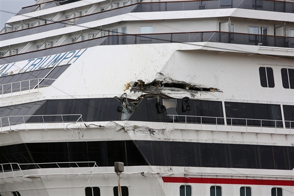
A close-up photograph of some of the damage incurred to the cruise ship, Triumph, after fierce winds caused the ship to break loose from its moorings in the early afternoon of April 3, 2013. Courtesy of the Associated Press.
Yet these fierce winds were related to the mesoscale convective system (MCS) that moved across the Gulf Coast States on Wednesday (check out the 17Z mosaic of composite reflectivity). For starters, a mesoscale convective system is any meso-beta (20 to 200 kilometers) or meso-alpha (200 to 1000 kilometers) group of thunderstorms that are part of a contiguous area of convective and straitform rains that span 100 kilometers or more in at least one horizontal direction. This sequence of images of radar reflectivity displays some of the various kinds of precipitation structures associated with mesoscale convective systems (courtesy of UCAR and The Comet Program).
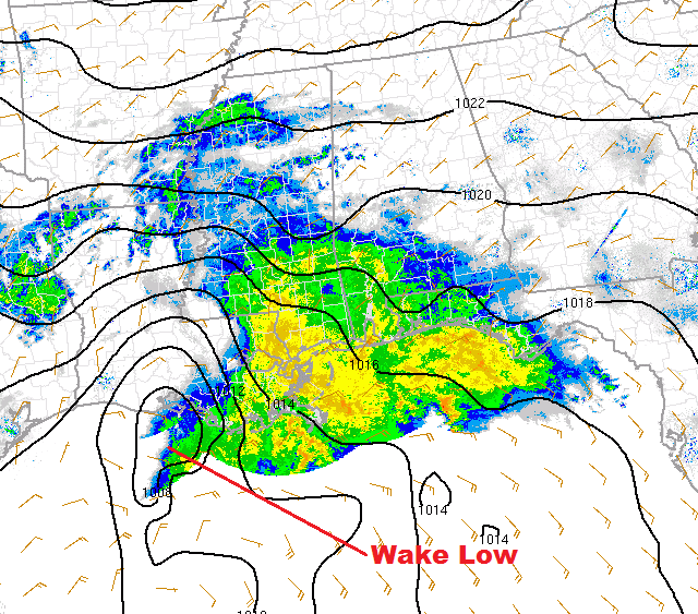
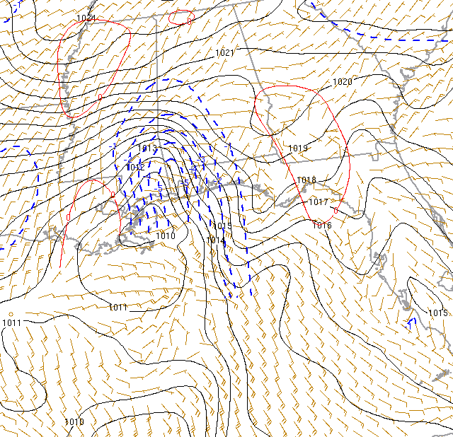
The 14Z Rapid Refresh model analysis of mean sea-level isobars (drawn every two millibars) and surface winds on April 3, 2013. The Rapid Refresh data were superimposed on base reflectivity. Note the wake low in the "wake" of the mesoscale convective system. Courtesy of the Storm Prediction Center.
Early on April 3, a mesoscale area of low pressure, formally called a wake low, followed in the "wake" of the mesoscale convective system. To see what I mean, check out the 14Z Rapid Refresh model analysis of mean sea-level isobars (drawn every two millibars) and surface winds superimposed on the 14Z base radar reflectivity (above). I annotated the image for you to see the position of the wake low relative to the MCS.
A wake low forms when subsiding air in the wake of the MCS warms on descent. In a nutshell, this compressional warming increases the mean temperature in columns of air that extend from the earth's surface to high in the stratosphere. This increase in mean column temperature decreases the mean column air density, which, in turn, lowers the weight of the air columns and the surface pressure (when the atmosphere is nearly hydrostatic, the weight of air columns from the earth's surface to near the top of the atmosphere serves as a proxy for surface air pressure).
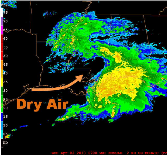
The 17Z mosaic of composite reflectivity on April 3, 2013. Note the tongue of dry air eroding the stratiform rain on the backside of the MCS. Courtesy of Penn State.
If we look more closely at the 17Z mosaic of composite reflectivity (above), it appears that there was a tongue of very dry air "cutting into" the trailing stratiform shield of precipitation on the backside of the mesoscale convective system. To get a better sense for how this mid-level very dry air literally charged into the wake of the MCS, check out this 10-hour loop of radar reflectivities (takes a moment to load; courtesy of SPC) that span from 0935Z to 1935Z. The dark region on the 17Z water vapor image from GOES-13 confirms the notion of intruding dry, mid-level air. At any rate, seasoned forecasters recognize this "charge" of very dry mid-level air as a precursor for high-wind episodes associated with wake lows. So I'm really suggesting that nowcasting this event would fall into the category of pattern recognition.
When a tongue of very dry mid-level air originating over the high deserts of the Southwest "charges" eastward and intrudes beneath the anvil cloud of a mesoscale convective system, precipitation falling from the anvil of the MCS completely evaporates. Now subsiding air dramatically warms at the DALR (dry adiabatic lapse rate), markedly increasing the mean temperature in air columns and lowering air densities, column weights and, ultimately, surface pressure. If the layer of intruding dry air is sufficiently deep and surges eastward in the vicinity of the wake low, there can be rapid and dramatic hydrostatic pressure falls at the earth's surface, paving the way for strong surface winds.
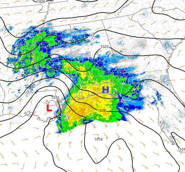
The 17Z Rapid Refresh model analysis of mean sea-level isobars and surface winds on April 3, 2013. The red "L" and the blur "H" indicate, respectively, the wake low and mesohigh associated with rain-cooled air. Courtesy of SPC.
Let's look more closely at the mesoscale weather pattern around midday. Check out, above, the 17Z Rapid Refresh model analysis of mean sea-level isobars, surface winds and base reflectivity. Remember that isobars are drawn every two millibars, so the pressure gradient between the wake low (the red "L") and the mesohigh associated with relatively dense, rain-cooled air (the blue "H") looks a bit larger than it actually was. Certainly, the winds generated by this rather modest pressure gradient were not strong enough to move a cruise ship off its moorings. No, there was something else going on.
Take a look (below) at the 19Z Rapid Refresh model analysis of 2-hour pressure tendency (dashed blue contours represent pressure falls, expressed in millibars per two hours). If you look closely, you'll observe an isallobar labeled minus five millibars per two hours (between 17Z and 19Z) in the vicinity of the wake low, indicating the dramatic impact on surface pressure caused by the eastward "charging" mid-level dry air that I discussed earlier. In contrast, there were only modest positive pressure tendencies associated with the mesohigh during these two hours.
The 19Z Rapid Refresh model analysis of 2-hour pressure tendencies on April 3, 2013. Dashed, blue contours indicate negative pressure tendencies (pressure decreased during the two-hour period from 17Z to 19Z). Courtesy of SPC.
Nonetheless, the pocket of negative pressure tendencies in the vicinity of the rapidly intensifying wake low promoted strong isallobaric acceleration toward the west, helping to generate damaging, "non-thunderstorm" winds. For the record, the isallobaric wind is an ageostrophic component of the wind that arises from changes in pressure over time. In general terms, it blows from a pocket of positive pressure tendencies toward a pocket of negative pressure tendencies (check out this example of the isallobaric wind component...contours are isallobars representing surface pressure changes over a period of three hours).
Quite an event, wouldn't you agree?
Lee
Recent News Mesoscale Forecasting
The views of the author are his/her own and do not necessarily represent the position of The Weather Company or its parent, IBM.