WunderBlog Archive » Category 6™
Category 6 has moved! See the latest from Dr. Jeff Masters and Bob Henson here.Damaging Tornadoes Slam Plains
A devastating string of severe thunderstorms and tornadoes tracked through Texas, Oklahoma, Kansas, and Nebraska on Saturday. This severe weather outbreak was remarkable in its duration as supercell thunderstorms began to pop up in western Kansas late Saturday morning, and the dry line that was supposed to represent the end of the severe weather threat was only halfway through Kansas, Oklahoma, and Texas by 1:00 AM Central Time Sunday. The moisture difference on either side of this dry line was remarkable as well, with dew points in the upper 60's to the east, and a very dry 20's to the west.
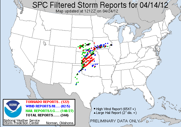
SPC Storm Reports from Saturday
The SPC storm reports show the track of these storms, with Kansas being the hardest hit. Early in the afternoon, most of the supercell thunderstorms were consistently producing weak tornadoes that skipped across western and central Kansas. As the low-level jet stream kicked in late in the afternoon and into the evening, the thunderstorms strengthened considerably. Probably the most remarkable supercell thunderstorm began in western Oklahoma near Woodward as a stunning multi-vortex tornado. The tornado actually was several tornadoes that danced into southern Kansas and eventually threatened Wichita. The tornado passed just south and east of the city, producing an 84 mph wind gust at the Wichita Airport. It also did extensive damage at the airport. In addition, the Oaklawn area of Wichita was declared a disaster area very soon after the tornado passed. The Sedgwick County commissioner declared the county a disaster area. This wedge tornado eventually moved along the Kansas Turnpike northeast of Wichita before finally dissipating.

Figure 1. Double tornadoes in Oklahoma close to the Kansas border. Image credit: news9.com

Figure 2. This tornado sparked a fire in Oklahoma as it passed through the area northeast of Woodward. Image credit: news9.com
The deadliest tornado of the outbreak struck Woodward, OK early Sunday morning, as the main squall line moved through western Oklahoma. This tornado was very large and particularly dangerous since it occurred at night when most residents assumed the threat had ended. There were multiple reports of not hearing the city's siren, so it is entirely possible that the siren was either struck by lightning or hit by the tornado itself. At least five deaths have been confirmed in the Woodward area from this tornado. Probably the scariest video of a tornado I have ever seen was taken of this Woodward tornado as it moved into town. Note you can see the scale of the tornado as between power flashes.
Video 1. Storm chaser video of one of Saturday's impressive tornadoes near Salina, Kansas.

Figure 3. Radar reflectivity image of the tornado that hit the south side of Wichita, Kansas, causing damage at the Wichita airport.
Perhaps the most telling feature of this severe weather outbreak was its repetitive nature. Salina, KS was tornado warned three times by three separate severe thunderstorms. Similarly, areas from Medicine Lodge to Kingman, Kansas were warned for two separate thunderstorms, while Woodward itself was warned very early in the day before a different tornado moved through the city late in the night.
Last night's storms have weakened, but a new round of severe weather is expected Sunday afternoon over portions of Wisconsin, Minnesota, and Iowa. NOAA's Storm Prediction Center has put the region under their second highest level of alert, a "Moderate Risk."
Shaun Tanner
SPC Storm Reports from Saturday
The SPC storm reports show the track of these storms, with Kansas being the hardest hit. Early in the afternoon, most of the supercell thunderstorms were consistently producing weak tornadoes that skipped across western and central Kansas. As the low-level jet stream kicked in late in the afternoon and into the evening, the thunderstorms strengthened considerably. Probably the most remarkable supercell thunderstorm began in western Oklahoma near Woodward as a stunning multi-vortex tornado. The tornado actually was several tornadoes that danced into southern Kansas and eventually threatened Wichita. The tornado passed just south and east of the city, producing an 84 mph wind gust at the Wichita Airport. It also did extensive damage at the airport. In addition, the Oaklawn area of Wichita was declared a disaster area very soon after the tornado passed. The Sedgwick County commissioner declared the county a disaster area. This wedge tornado eventually moved along the Kansas Turnpike northeast of Wichita before finally dissipating.
Figure 1. Double tornadoes in Oklahoma close to the Kansas border. Image credit: news9.com
Figure 2. This tornado sparked a fire in Oklahoma as it passed through the area northeast of Woodward. Image credit: news9.com
The deadliest tornado of the outbreak struck Woodward, OK early Sunday morning, as the main squall line moved through western Oklahoma. This tornado was very large and particularly dangerous since it occurred at night when most residents assumed the threat had ended. There were multiple reports of not hearing the city's siren, so it is entirely possible that the siren was either struck by lightning or hit by the tornado itself. At least five deaths have been confirmed in the Woodward area from this tornado. Probably the scariest video of a tornado I have ever seen was taken of this Woodward tornado as it moved into town. Note you can see the scale of the tornado as between power flashes.
Video 1. Storm chaser video of one of Saturday's impressive tornadoes near Salina, Kansas.
Figure 3. Radar reflectivity image of the tornado that hit the south side of Wichita, Kansas, causing damage at the Wichita airport.
Perhaps the most telling feature of this severe weather outbreak was its repetitive nature. Salina, KS was tornado warned three times by three separate severe thunderstorms. Similarly, areas from Medicine Lodge to Kingman, Kansas were warned for two separate thunderstorms, while Woodward itself was warned very early in the day before a different tornado moved through the city late in the night.
Last night's storms have weakened, but a new round of severe weather is expected Sunday afternoon over portions of Wisconsin, Minnesota, and Iowa. NOAA's Storm Prediction Center has put the region under their second highest level of alert, a "Moderate Risk."
Shaun Tanner
Thunderstorm Wind Damage

Freak Hail Storm Texas Panhandle

Night tornado

Clouds II

The views of the author are his/her own and do not necessarily represent the position of The Weather Company or its parent, IBM.