WunderBlog Archive » Category 6™
Category 6 has moved! See the latest from Dr. Jeff Masters and Bob Henson here.Chapala Slams Yemen: First Hurricane-Strength Cyclone on Record
Residents of southern Yemen are assessing the damage after Cyclone Chapala brought dramatic flooding to the region on Monday night into Tuesday. According to the Indian Meteorological Department (IMD), Chapala made landfall near 14.1°N, 48.65°E between 01Z and 02Z Wednesday (4:00 - 5:00 am local time, or 8:00 – 9:00 pm Tuesday EST). This location is about 40 miles southwest of the coastal city of Mukalla (Al Mukalla), which was slammed by Chapala’s right-hand eyewall and some of its heaviest rains. Infrared satellite imagery shows a pronounced burst of convection (showers and thunderstorms) near and just west of Mukalla as Chapala made landfall.

Figure 1. A MODIS satellite view of Chapala as it approached the Gulf of Aden on Tuesday, November 2, 2015. Image credit: NASA EarthData.

Figure 2. Although Chapala’s eye was indistinct at landfall, thunderstorms intensified near its center as it came ashore, as shown in the pink and grey in this infrared satellite image taken near landfall (0100Z Wednesday, November 3, 2015). Image credit: Scott Bachmeier, CIMMS/SSEC/University of Wisconsin.
Yemen’s first hurricane-strength cyclone on record
IMD estimates Chapala’s peak winds at landfall as 65-70 knots (75-80 mph). India uses 3-minute sustained wind speeds, as opposed to the 1-minute average used by the National Hurricane Center. Guidance from NHC suggests that Chapala’s peak 1-minute winds would likely be several percent higher. Supporting the idea that Chapala made landfall at hurricane strength, the weather station at the Riyan airport, located about 20 miles northeast of Mukalla (Al Mukalla), recorded top sustained winds of 73 mph, gusting to 89 mph, before the sensor stopped reporting. Winds at Riyan were still increasing at the time, suggesting that hurricane-force winds probably occurred at some point in Chapala’s path during landfall. The nation experienced a destructive tropical depression in 2008 and a tropical storm-strength cyclone in 1960, but there are no hurricane-strength landfalls on record. Satellite records extend back to 1990, while a separate IMD database goes back to 1891.
Chapala moved mainly toward the west after landfall, hugging the Yemeni coastline, but the center is now making its way inland. At 15Z Wednesday (10:00 am EDT), the Joint Typhoon Warning Center placed Chapala’s center near 14.1°N, 47.5°E, or about 100 miles west of Mukalla. Based on the limited data available, JTWC estimated that Chapala still had sustained winds of 55 knots (62 mph).

Figure 3. An infrared view of Cyclone Chapala at 1530Z (10:30 am EST) Wednesday, November 3, 2015. Image credit: CIMMS/SSEC/University of Wisconsin.
As expected, the dry air and high terrain of southern Yemen has taken its toll on Chapala. Satellite imagery shows that the cyclone has become highly disorganized, with showers and thunderstorms decreasing and weakening around its ill-defined center. A pocket of more intense thunderstorms has popped up along the high terrain of Yemen’s west coast, well away from Chapala’s core circulation. Strong thunderstorms have also persisted in northeast Somalia, across the Gulf of Aden from Chapala. Villages along the Somalian coast have been affected by heavy rain and coastal flooding, according to Garowe Online. Prior to Chapala’s landfall in Yemen, the remote island of Socotra was hard-hit by the cyclone’s left-hand flank, with at least three fatalities reported by Reuters via a local official.

Figure 4. Waves ahead of Cyclone Chapala batter the coast of Yemen near Mukalla on Monday, November 2, 2015. Image credit: AP Photo/Mohammed Bazahier.
With Yemen plagued by civil war, it is difficult to know how extensive the damage from Chapala has been. Photos and video emerging on social media from Mukalla show major flooding, with several feet of water cascading through streets and out of the banks of a canal that runs through the heart of the city. Independent Yemen-based journalist Iona Craig reported a preliminary total of 25 injuries and 21 people missing. No fatalities have been reported thus far--an encouraging sign, although it is still very early in the process of damage assessment. “The damage is enormous,” Fahd Kafain, Yemen’s minister of fisheries, told AFP. The mountain valleys of the Hadramout region have experienced dramatic runoff from Chapala’s rains (see embedded YouTube clip below). Hadramout suffered more than 200 fatalities related to the 2008 Yemen cyclone. The impact of Chapala will undoubtedly hamper the already-difficult tasks facing humanitarian relief agencies in Yemen. Storm surge expert Hal Needham has a blog post this morning on Chapala’s landfall, including background on how topography helped tamp down the potential storm surge along the Yemen coastline.
Recent runs of the ECWMF, GFS, and UKMET models suggest that a disturbance now off the southwest coast of India could undergo tropical development in the Arabian Sea later this week, again heading toward the Arabian Peninsula. If a new cyclone were to pass directly over the same region as Chapala, it would be unlikely to attain the same strength, given the cooler waters that were stirred up by Chapala’s passage.

Figure 5. Cyclone Chapala (left) and a disturbance off the southwest coast of India, as captured by satellite at 18Z (1:00 pm EST) Wednesday, November 3, 2015. Image credit: EUMETSAT/JTWC/SATOPS.
Did climate change have anything to do with Chapala?
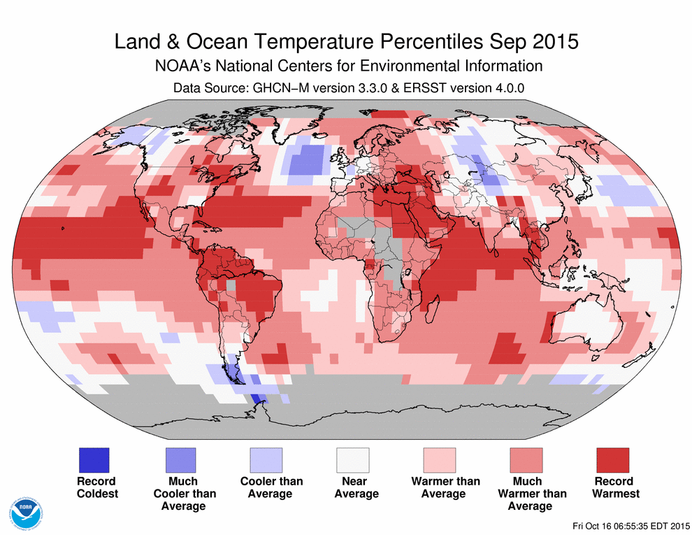
There is no doubt that Chapala was an extremely unusual cyclone--although we don’t know exactly how unusual, given the sketchy nature of tropical cyclone records for the Arabian Sea prior to 1990. Assuming that other factors line up favorably, then warm sea-surface temperatures boost the odds of cyclone development. In this case, Chapala formed and traveled over waters that were at record-warm levels for this time of year (see Figure 6 below). Chapala was not only the second-strongest cyclone on record for the Arabian Sea, but it was also the longest-lived at Category 3 strength. According to WU contributor Phil Klotzbach, Chapala was a major cyclone for 3.75 days, breaking the old record of 3.25 days set in 2007 by Cyclone Sidr. Due to its longevity and strength, Chapala has also generated more accumulated cyclone energy than any other Arabian Sea cyclone on record.

Figure 4. Tropical Cyclone Chapala performed its remarkable rapid intensification cycle over the warmest waters ever observed for this time of year over the Arabian Sea, as depicted in the September 2015 global climate summary from NOAA/NCEI.
Tropical cyclones are most common in the Arabian Sea in spring and autumn, during the transition periods between the strong southwest flow of the summer monsoon and the strong northeast flow that predominates in winter. A 2011 paper in Nature led by Amato Evan (University of Virginia) found that during the pre-monsoon period (spring), vertical wind shear decreased and Arabian Sea cyclones became considerably stronger in 1997-2010 as compared to 1979-1996. The authors attribute the reduced shear to a regional increase in sun-blocking air pollution, mainly black carbon and sulfates). A much more subtle decrease in strength was found for post-monsoon (autumn) cyclones in the Arabian Sea. However, the authors speculated that if emissions continued to grow, “it is plausible that very intense tropical cyclones, which have so far been limited to the pre-monsoon period, could begin to emerge in the post-monsoon season as well."
Bob Henson
Figure 1. A MODIS satellite view of Chapala as it approached the Gulf of Aden on Tuesday, November 2, 2015. Image credit: NASA EarthData.
Figure 2. Although Chapala’s eye was indistinct at landfall, thunderstorms intensified near its center as it came ashore, as shown in the pink and grey in this infrared satellite image taken near landfall (0100Z Wednesday, November 3, 2015). Image credit: Scott Bachmeier, CIMMS/SSEC/University of Wisconsin.
Yemen’s first hurricane-strength cyclone on record
IMD estimates Chapala’s peak winds at landfall as 65-70 knots (75-80 mph). India uses 3-minute sustained wind speeds, as opposed to the 1-minute average used by the National Hurricane Center. Guidance from NHC suggests that Chapala’s peak 1-minute winds would likely be several percent higher. Supporting the idea that Chapala made landfall at hurricane strength, the weather station at the Riyan airport, located about 20 miles northeast of Mukalla (Al Mukalla), recorded top sustained winds of 73 mph, gusting to 89 mph, before the sensor stopped reporting. Winds at Riyan were still increasing at the time, suggesting that hurricane-force winds probably occurred at some point in Chapala’s path during landfall. The nation experienced a destructive tropical depression in 2008 and a tropical storm-strength cyclone in 1960, but there are no hurricane-strength landfalls on record. Satellite records extend back to 1990, while a separate IMD database goes back to 1891.
Chapala moved mainly toward the west after landfall, hugging the Yemeni coastline, but the center is now making its way inland. At 15Z Wednesday (10:00 am EDT), the Joint Typhoon Warning Center placed Chapala’s center near 14.1°N, 47.5°E, or about 100 miles west of Mukalla. Based on the limited data available, JTWC estimated that Chapala still had sustained winds of 55 knots (62 mph).
Figure 3. An infrared view of Cyclone Chapala at 1530Z (10:30 am EST) Wednesday, November 3, 2015. Image credit: CIMMS/SSEC/University of Wisconsin.
As expected, the dry air and high terrain of southern Yemen has taken its toll on Chapala. Satellite imagery shows that the cyclone has become highly disorganized, with showers and thunderstorms decreasing and weakening around its ill-defined center. A pocket of more intense thunderstorms has popped up along the high terrain of Yemen’s west coast, well away from Chapala’s core circulation. Strong thunderstorms have also persisted in northeast Somalia, across the Gulf of Aden from Chapala. Villages along the Somalian coast have been affected by heavy rain and coastal flooding, according to Garowe Online. Prior to Chapala’s landfall in Yemen, the remote island of Socotra was hard-hit by the cyclone’s left-hand flank, with at least three fatalities reported by Reuters via a local official.
Figure 4. Waves ahead of Cyclone Chapala batter the coast of Yemen near Mukalla on Monday, November 2, 2015. Image credit: AP Photo/Mohammed Bazahier.
With Yemen plagued by civil war, it is difficult to know how extensive the damage from Chapala has been. Photos and video emerging on social media from Mukalla show major flooding, with several feet of water cascading through streets and out of the banks of a canal that runs through the heart of the city. Independent Yemen-based journalist Iona Craig reported a preliminary total of 25 injuries and 21 people missing. No fatalities have been reported thus far--an encouraging sign, although it is still very early in the process of damage assessment. “The damage is enormous,” Fahd Kafain, Yemen’s minister of fisheries, told AFP. The mountain valleys of the Hadramout region have experienced dramatic runoff from Chapala’s rains (see embedded YouTube clip below). Hadramout suffered more than 200 fatalities related to the 2008 Yemen cyclone. The impact of Chapala will undoubtedly hamper the already-difficult tasks facing humanitarian relief agencies in Yemen. Storm surge expert Hal Needham has a blog post this morning on Chapala’s landfall, including background on how topography helped tamp down the potential storm surge along the Yemen coastline.
Recent runs of the ECWMF, GFS, and UKMET models suggest that a disturbance now off the southwest coast of India could undergo tropical development in the Arabian Sea later this week, again heading toward the Arabian Peninsula. If a new cyclone were to pass directly over the same region as Chapala, it would be unlikely to attain the same strength, given the cooler waters that were stirred up by Chapala’s passage.
Figure 5. Cyclone Chapala (left) and a disturbance off the southwest coast of India, as captured by satellite at 18Z (1:00 pm EST) Wednesday, November 3, 2015. Image credit: EUMETSAT/JTWC/SATOPS.
Did climate change have anything to do with Chapala?
There is no doubt that Chapala was an extremely unusual cyclone--although we don’t know exactly how unusual, given the sketchy nature of tropical cyclone records for the Arabian Sea prior to 1990. Assuming that other factors line up favorably, then warm sea-surface temperatures boost the odds of cyclone development. In this case, Chapala formed and traveled over waters that were at record-warm levels for this time of year (see Figure 6 below). Chapala was not only the second-strongest cyclone on record for the Arabian Sea, but it was also the longest-lived at Category 3 strength. According to WU contributor Phil Klotzbach, Chapala was a major cyclone for 3.75 days, breaking the old record of 3.25 days set in 2007 by Cyclone Sidr. Due to its longevity and strength, Chapala has also generated more accumulated cyclone energy than any other Arabian Sea cyclone on record.
Figure 4. Tropical Cyclone Chapala performed its remarkable rapid intensification cycle over the warmest waters ever observed for this time of year over the Arabian Sea, as depicted in the September 2015 global climate summary from NOAA/NCEI.
Tropical cyclones are most common in the Arabian Sea in spring and autumn, during the transition periods between the strong southwest flow of the summer monsoon and the strong northeast flow that predominates in winter. A 2011 paper in Nature led by Amato Evan (University of Virginia) found that during the pre-monsoon period (spring), vertical wind shear decreased and Arabian Sea cyclones became considerably stronger in 1997-2010 as compared to 1979-1996. The authors attribute the reduced shear to a regional increase in sun-blocking air pollution, mainly black carbon and sulfates). A much more subtle decrease in strength was found for post-monsoon (autumn) cyclones in the Arabian Sea. However, the authors speculated that if emissions continued to grow, “it is plausible that very intense tropical cyclones, which have so far been limited to the pre-monsoon period, could begin to emerge in the post-monsoon season as well."
Bob Henson
Waist high flood coastal Mukallah, vid: https://t.co/92yalH2dtF
as debris flows race through interior toward coast pic.twitter.com/VAO3HXaTP6
— Jane Novak (@JNovak_Yemen) November 3, 2015The views of the author are his/her own and do not necessarily represent the position of The Weather Company or its parent, IBM.