WunderBlog Archive » Category 6™
Category 6 has moved! See the latest from Dr. Jeff Masters and Bob Henson here.Category 5 Super Typhoon Maysak Pounding Micronesia
Extremely dangerous Category 5 Super Typhoon Maysak is pounding the islands of Yap State in Micronesia's Caroline Islands. At 8 am EDT Tuesday the Joint Typhoon Warning Center (JTWC) put Maysak's top sustained winds at 160 mph, making it one of only three Category 5 storms ever observed in the Northwestern Pacific prior to April. The Japan Meteorological Agency (JMA) put Maysak's central pressure at 905 mb, the lowest pressure they have estimated for any Northwestern Pacific typhoon occurring so early in the year (previous record: 930 mb for Typhoon Mitag of March 2002, Typhoon Alice of January 1979, and Typhoon Harriet of January 1959.) According to the NWS in Guam, the eye of Maysak has already passed very close to several of the smaller islands of Micronesia--Ulithi and Fais--bringing hurricane-force winds. Ulithi is an atoll about 12 feet above sea level, and Fais is 30 feet above sea level, so storm surge flooding is a huge concern on these low-lying islands. The 00 UTC Tuesday runs of the GFS and European models predict that the center of Maysak will pass about 100 miles northeast of Yap in the Caroline Islands (population 11,000) near 2 pm EDT Tuesday, which is near dawn local time on Wednesday. Since hurricane-force winds extend out about 45 miles from the center, Yap will likely only receive tropical storm-force winds. However, the significant wave heights in Maysak were estimated at 40 feet, and Yap will receive substantial coastal damage and flooding from the storm. Maysak has moderate wind shear of 10 - 20 knots and a large area of ocean with sea surface temperatures of 28 - 29°C (83 - 84°F) to work with through Wednesday, and will be capable of maintaining Category 5 strength until Thursday. As Maysak approaches the Philippines on Friday and Saturday, wind shear will rise, sea surface temperatures will cool, and the total heat energy in the ocean will decrease sharply, which should weaken Maysak significantly. The Joint Typhoon Warning Center (JTWC) is predicting that Maysak will be a Category 3 storm on Saturday, and at least a Category 1 typhoon when it hits Luzon Island in the Philippines on Easter Sunday.

Figure 1. MODIS satellite image of Super Typhoon Maysak taken at 03:55 UTC March 31, 2015. At the time, Maysak was a Category 5 storm with 160 mph winds. Image credit: NASA.
A record early start to typhoon season
According to the Joint Typhoon Warning Center (JTWC) database, 2015 is now the only season since records began in 1945 to feature three typhoons during the first three months of the year (January, February, and March), and also the first season to have two major typhoons (Category 3 or stronger) during the first three months of the year. The other major typhoon of 2015 was Typhoon Higos, which topped out as a Category 3 storm with 120 mph winds in February. Maysak is the fourth named storm so far in 2015 in the Northwestern Pacific, and only one other year since 1945 had more named storms by this point--1965, when there were five named storms by the end of March. The previous record for early season typhoons (during January, February, and March) was two, set in 2005, 1979, and 1955. Major typhoons of Category 3 or stronger intensity are rare before April, and only fifteen such storms have been observed between 1945 - 2014. Two of these were Category 5 super typhoons: Super Typhoon Ophelia of January 1958 with 160 mph winds, and Super Typhoon Mitag of March 2002, also with 160 mph winds.
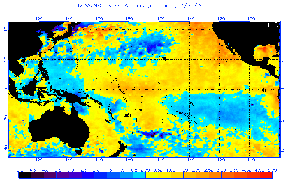
The unusually early start to typhoon season is due, in part, to exceptionally warm waters in the typhoon breeding grounds just west of the International Date Line between 5 - 10° latitude, due to the weak El Niño event that is occurring. Water temperatures there are about 1 - 2°C (1.8 - 3.6°F) warmer than average. Also aiding typhoon formation this month was the strongest MJO event since record keeping began in 1974, which moved through the Western Pacific in mid-March. This MJO event generated an unusually strong band of west-to-east blowing surface winds near the Equator (a "westerly wind burst") that helped spin up Maysak and the storm that preceded it, Tropical Storm Bavi. This "westerly wind burst" will be strengthened by the counter-clockwise flow of air around Maysak, increasing the chances of El Niño lasting into the summer and potentially strengthening this fall. This process could potentially be aided by another tropical storm that the GFS model predicts will develop late this week from Invest 99W, in a location similar to where Maysak developed.
Maysak causes heavy damage to Chuuk
Maysak has already dealt a heavy blow to the islands in the Chuuk State in the Federated States of Micronesia, which have a population of about 50,000. Maysak passed through the islands as a Category 1 storm over the weekend, causing severe damage and five deaths. The eye of the storm passed directly over Weno Island, which recorded a wind gust of 71 mph and almost 7 inches of rain. Communications with Chuuk State are still difficult, so it is uncertain how much damage was done--though early reports indicate that up to 90% of the homes were damaged or destroyed by the storm.
Video 1. Damage in Micronesia's Chuuk State from Typhoon Maysak.
Links
Wunderblogger Lee Grenci has a new post a new post about the upper-level environmentdiscussing how favorable the upper level winds were for allowing Maysak to intensify into a Category 5 storm.
High resolution visible loop of Maysak from March 31, 2015 from CIMSS
High resolution visible loop of Maysak until sunset on March 30, 2015 from CIMSS
Bob Henson will have a new post early this afternoon on the U.S. severe weather potential this week, a major "pattern shift" coming to our weather, and an update on El Niño.
Jeff Masters
Figure 1. MODIS satellite image of Super Typhoon Maysak taken at 03:55 UTC March 31, 2015. At the time, Maysak was a Category 5 storm with 160 mph winds. Image credit: NASA.
A record early start to typhoon season
According to the Joint Typhoon Warning Center (JTWC) database, 2015 is now the only season since records began in 1945 to feature three typhoons during the first three months of the year (January, February, and March), and also the first season to have two major typhoons (Category 3 or stronger) during the first three months of the year. The other major typhoon of 2015 was Typhoon Higos, which topped out as a Category 3 storm with 120 mph winds in February. Maysak is the fourth named storm so far in 2015 in the Northwestern Pacific, and only one other year since 1945 had more named storms by this point--1965, when there were five named storms by the end of March. The previous record for early season typhoons (during January, February, and March) was two, set in 2005, 1979, and 1955. Major typhoons of Category 3 or stronger intensity are rare before April, and only fifteen such storms have been observed between 1945 - 2014. Two of these were Category 5 super typhoons: Super Typhoon Ophelia of January 1958 with 160 mph winds, and Super Typhoon Mitag of March 2002, also with 160 mph winds.
The unusually early start to typhoon season is due, in part, to exceptionally warm waters in the typhoon breeding grounds just west of the International Date Line between 5 - 10° latitude, due to the weak El Niño event that is occurring. Water temperatures there are about 1 - 2°C (1.8 - 3.6°F) warmer than average. Also aiding typhoon formation this month was the strongest MJO event since record keeping began in 1974, which moved through the Western Pacific in mid-March. This MJO event generated an unusually strong band of west-to-east blowing surface winds near the Equator (a "westerly wind burst") that helped spin up Maysak and the storm that preceded it, Tropical Storm Bavi. This "westerly wind burst" will be strengthened by the counter-clockwise flow of air around Maysak, increasing the chances of El Niño lasting into the summer and potentially strengthening this fall. This process could potentially be aided by another tropical storm that the GFS model predicts will develop late this week from Invest 99W, in a location similar to where Maysak developed.
Maysak causes heavy damage to Chuuk
Maysak has already dealt a heavy blow to the islands in the Chuuk State in the Federated States of Micronesia, which have a population of about 50,000. Maysak passed through the islands as a Category 1 storm over the weekend, causing severe damage and five deaths. The eye of the storm passed directly over Weno Island, which recorded a wind gust of 71 mph and almost 7 inches of rain. Communications with Chuuk State are still difficult, so it is uncertain how much damage was done--though early reports indicate that up to 90% of the homes were damaged or destroyed by the storm.
Video 1. Damage in Micronesia's Chuuk State from Typhoon Maysak.
Links
Wunderblogger Lee Grenci has a new post a new post about the upper-level environmentdiscussing how favorable the upper level winds were for allowing Maysak to intensify into a Category 5 storm.
High resolution visible loop of Maysak from March 31, 2015 from CIMSS
High resolution visible loop of Maysak until sunset on March 30, 2015 from CIMSS
Bob Henson will have a new post early this afternoon on the U.S. severe weather potential this week, a major "pattern shift" coming to our weather, and an update on El Niño.
Jeff Masters
The views of the author are his/her own and do not necessarily represent the position of The Weather Company or its parent, IBM.