WunderBlog Archive » Category 6™
Category 6 has moved! See the latest from Dr. Jeff Masters and Bob Henson here.Bertha turns to the east, Invest 94L still there
Tropical Storm Bertha has finally turned toward the east at 6 mph and is now packing maximum sustained winds of 65 mph and her central pressure has ticked up to 996 mb. A general track to the east is expected to continue for the next few days with slight strengthening possible.
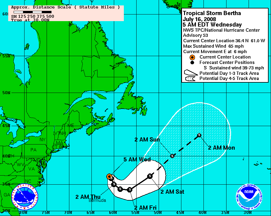
Bertha - Watches and Warnings
Bertha is starting to look pretty ragged on satellite imagery. Her circulation is becoming elongated due to synoptic steering patterns, but shear over the center of circulation remains low. Deep convection is limited but sufficient to maintain intensity at this time.

Bertha - Infrared satellite
As Bertha moves to the east, large meanders are expected in her track. Additionally, there is slightly warmer water ahead of the storm so slight strengthening is possible. Bertha is still not expected to be a threat to land of the next week. Shipping interests should still monitor the storm as there is a huge amount of divergence in track forecasts beyond 72 hours.
Click for full size model imagery:

Bertha - Track Forecast

Bertha - Wind Speed Forecast
The wave that has been traveling across the Atlantic still does not look that well organized, but convection has increased from yesterday. Right now I give the system a roughly 40% chance of development. Convection has finally started to build near the center of circulation, but has not been sustained enough to create a closed circulation. We will continue to monitor the system for signs of development.

Invest 94L - Infrared satellite
Model forecasts still bring this area of interest over the eastern Caribbean, which is often not favorable for tropical development. None of the models go crazy with this system, but some do still show signs of development.
Click for full size model imagery:

Invest 94L - Track Forecast

Invest 94L - Intensity Forecast
Elsewhere in the Atlantic, there is an area of thunderstorms over the northeast Gulf of Mexico that has a slight chance of reaching tropical depression status before arriving over Florida. No threat is expected from this system and it could bring beneficial rains to the northern Florida area.

Area of storms approaching Florida
Writing for Jeff Masters for the week, Bryan Woods
Bertha - Watches and Warnings
Bertha is starting to look pretty ragged on satellite imagery. Her circulation is becoming elongated due to synoptic steering patterns, but shear over the center of circulation remains low. Deep convection is limited but sufficient to maintain intensity at this time.
Bertha - Infrared satellite
As Bertha moves to the east, large meanders are expected in her track. Additionally, there is slightly warmer water ahead of the storm so slight strengthening is possible. Bertha is still not expected to be a threat to land of the next week. Shipping interests should still monitor the storm as there is a huge amount of divergence in track forecasts beyond 72 hours.
Click for full size model imagery:

Bertha - Track Forecast

Bertha - Wind Speed Forecast
The wave that has been traveling across the Atlantic still does not look that well organized, but convection has increased from yesterday. Right now I give the system a roughly 40% chance of development. Convection has finally started to build near the center of circulation, but has not been sustained enough to create a closed circulation. We will continue to monitor the system for signs of development.
Invest 94L - Infrared satellite
Model forecasts still bring this area of interest over the eastern Caribbean, which is often not favorable for tropical development. None of the models go crazy with this system, but some do still show signs of development.
Click for full size model imagery:

Invest 94L - Track Forecast

Invest 94L - Intensity Forecast
Elsewhere in the Atlantic, there is an area of thunderstorms over the northeast Gulf of Mexico that has a slight chance of reaching tropical depression status before arriving over Florida. No threat is expected from this system and it could bring beneficial rains to the northern Florida area.
Area of storms approaching Florida
Writing for Jeff Masters for the week, Bryan Woods
The views of the author are his/her own and do not necessarily represent the position of The Weather Company or its parent, IBM.