WunderBlog Archive » Category 6™
Category 6 has moved! See the latest from Dr. Jeff Masters and Bob Henson here.Bertha approaches Bermuda, Invest 94L likely to develop
One can tell that it is quickly becoming late July when the tropics start to heat up to the point when there are two systems to monitor in the Atlantic. Right now we are monitoring Tropical Storm Bertha close in on Bermuda at the same time as we watch Invest 94L approach the Lesser Antilles. Of the two systems, Invest 94L has the potential to create a much higher impact event.
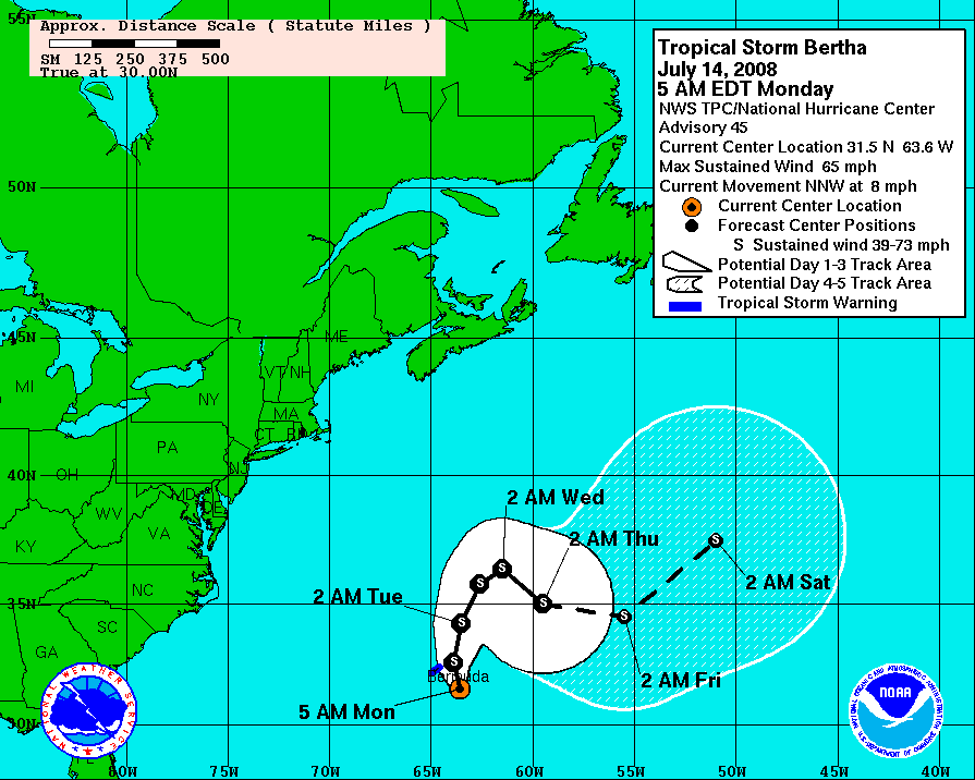
Tropical Storm Bertha is holding on to strong tropical storm intensity as she wanders around the North Atlantic and slowly approaches Bermuda with maximum sustained winds of 65 mph and a central pressure of 990 mb. Bertha is finally making steady progress to the north-northwest at 8 mph which should brush her right up against Bermuda with 3-5 inches of rain, tropical storm force winds, and seas up to 18 feet. On Saturday I was flying from Hartford to Philadelphia and could see swells rolling off of Bertha reaching the East Coast of the U.S.
Bertha - Watches and Warnings
Storm's of Bertha's size and maturity rarely exhibit rapid intensity changes, especially as far north as Bermuda, unless they interact with some mid-latitude synoptic feature. Since Bertha is pretty well isolated in the middle of the Atlantic, significant changed in intensity are not expected over the coming couple of days. Bertha has managed to maintain decent convection for a mid-latitude tropical system and features one prominent band to the north of the circulation.

Bertha - Infrared satellite
Currently the main band of Bertha is still offshore of Bermuda, but is approaching the island. Some convection ahead of the storm is already bringing heavy rain and tropical storm force winds. To monitor Bertha's impact on Bermuda, check with the Bermuda Weather Service'sradar page and their weather web cam, as well as current surface observations.

Bermuda radar
Motion first to the north and then to the east is expected over the next few days with some more wobbles to be expected on top of the general progression to the east. For the time being, I am disregarding the intensity forecast models as the general have little skill with tropical or hybrid systems in mid-latitudes. Instead 'persistence' seems like the best forecast for Bertha.
Click for full size model imagery:

Bertha - Track Forecast

Bertha - Wind Speed Forecast
Elsewhere in the Atlantic, halfway between Africa and the Lesser Antilles there is a strong tropical wave that looks likely to become a tropical depression in the next day or so. Convection has been persistent and is showing healthy curved outflow. Unfortunately we have yet to receive a good QuikScat pass of the system which is precluding me from making any bold statements about the circulation. While tropical waves do have associated cyclonic curvature in the flow, it seems unlikely at this point that a closed cyclonic circulation has yet developed. We'll wait for a more centralized core of convection and possibly verification from a QuikScat pass before we make that claim.

Invest 94L - Infrared satellite
Since yesterday is seems even more likely that Invest 94L will become Tropical Depression Three. It is far too early for public talk of a landfall at this time. You'll never see me issuing that kind of forecast until after a closed circulation is well-developed. Both the GFDL and the HWRF slowly develop the system as it tracks toward the west. The mostly likely situation is for us to see a strong tropical storm over the northeast Caribbean in about 5 days.
Click for full size model imagery:

Invest 94L - GFDL 5-Day Forecast

Invest 94L - HWRF 5-Day Forecast
However, the situation bears further watching. This system could eventually end up anywhere in the Caribbean, Gulf of Mexico, or western Atlantic, and at any strength. The model tracks are showing a huge spread which is expected. Weak systems, like invests, do not have a well developed circulation so differences in model initializations very often result in a wide range of track solutions, even among the members that agree on intensity.
Click for full size model imagery:

Invest 94L - Track Forecast

Invest 94L - Intensity Forecast
Writing from cheery old London this week, Bryan Woods.
Tropical Storm Bertha is holding on to strong tropical storm intensity as she wanders around the North Atlantic and slowly approaches Bermuda with maximum sustained winds of 65 mph and a central pressure of 990 mb. Bertha is finally making steady progress to the north-northwest at 8 mph which should brush her right up against Bermuda with 3-5 inches of rain, tropical storm force winds, and seas up to 18 feet. On Saturday I was flying from Hartford to Philadelphia and could see swells rolling off of Bertha reaching the East Coast of the U.S.
Bertha - Watches and Warnings
Storm's of Bertha's size and maturity rarely exhibit rapid intensity changes, especially as far north as Bermuda, unless they interact with some mid-latitude synoptic feature. Since Bertha is pretty well isolated in the middle of the Atlantic, significant changed in intensity are not expected over the coming couple of days. Bertha has managed to maintain decent convection for a mid-latitude tropical system and features one prominent band to the north of the circulation.
Bertha - Infrared satellite
Currently the main band of Bertha is still offshore of Bermuda, but is approaching the island. Some convection ahead of the storm is already bringing heavy rain and tropical storm force winds. To monitor Bertha's impact on Bermuda, check with the Bermuda Weather Service'sradar page and their weather web cam, as well as current surface observations.
Bermuda radar
Motion first to the north and then to the east is expected over the next few days with some more wobbles to be expected on top of the general progression to the east. For the time being, I am disregarding the intensity forecast models as the general have little skill with tropical or hybrid systems in mid-latitudes. Instead 'persistence' seems like the best forecast for Bertha.
Click for full size model imagery:

Bertha - Track Forecast

Bertha - Wind Speed Forecast
Elsewhere in the Atlantic, halfway between Africa and the Lesser Antilles there is a strong tropical wave that looks likely to become a tropical depression in the next day or so. Convection has been persistent and is showing healthy curved outflow. Unfortunately we have yet to receive a good QuikScat pass of the system which is precluding me from making any bold statements about the circulation. While tropical waves do have associated cyclonic curvature in the flow, it seems unlikely at this point that a closed cyclonic circulation has yet developed. We'll wait for a more centralized core of convection and possibly verification from a QuikScat pass before we make that claim.
Invest 94L - Infrared satellite
Since yesterday is seems even more likely that Invest 94L will become Tropical Depression Three. It is far too early for public talk of a landfall at this time. You'll never see me issuing that kind of forecast until after a closed circulation is well-developed. Both the GFDL and the HWRF slowly develop the system as it tracks toward the west. The mostly likely situation is for us to see a strong tropical storm over the northeast Caribbean in about 5 days.
Click for full size model imagery:
Invest 94L - GFDL 5-Day Forecast
Invest 94L - HWRF 5-Day Forecast
However, the situation bears further watching. This system could eventually end up anywhere in the Caribbean, Gulf of Mexico, or western Atlantic, and at any strength. The model tracks are showing a huge spread which is expected. Weak systems, like invests, do not have a well developed circulation so differences in model initializations very often result in a wide range of track solutions, even among the members that agree on intensity.
Click for full size model imagery:

Invest 94L - Track Forecast

Invest 94L - Intensity Forecast
Writing from cheery old London this week, Bryan Woods.
The views of the author are his/her own and do not necessarily represent the position of The Weather Company or its parent, IBM.