WunderBlog Archive » Category 6™
Category 6 has moved! See the latest from Dr. Jeff Masters and Bob Henson here.After Warmest Autumn on Record, December Mildness Sweeps Across U.S.
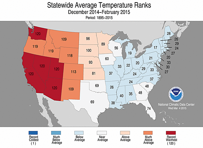
Meteorological autumn (September – November) was the warmest in 121 years of recordkeeping for the 48 contiguous U.S. states, according to NOAA’s national wrapup of November and fall conditions released Wednesday morning. The national average of 56.8°F was a full 3.3°F above the 20th-century average and 0.2°F above the previous record of 56.6°F (Sep-Nov 1963). Only one state (Florida) had its warmest autumn on record, but the nation as a whole still came out on top because of the rare coast-to-coast nature of the warmth. Often, one part of the country will have a mild three-month period while another part is colder than average, as we saw dramatically this past winter with record warmth in the West and unusual chill in the East.
This past autumn was also fairly damp on a national scale, with the 48 states recording their 15th wettest autumn. November came in on the mild and wet side for the contiguous U.S., ranking as the 13th warmest and 15th wettest November since records began in 1895.

Figure 1. Temperature ranks for each of the 48 contiguous U.S. states during autumn 2015 (September through November). Higher numbers indicate warmer readings. Florida had its warmest autumn on record (#121 out of 121 years). Image credit: NOAA National Centers for Environmental Information
The large-scale mildness hasn’t abated, as temperatures were well above freezing Wednesday morning over nearly all of the United States east of the Rockies. None of the nation's regular reporting stations in the contiguous 48 states--including mountain locations--managed to get below 10°F on Tuesday, according to Nick Wiltgen at weather.com. (By comparison, each day in December 2013 saw at least one sub-0°F reading in the Lower 48.) All this is leading into what looks like a unusually long stretch of very mild weather for mid-December. Even Canada’s largest city, Toronto, might avoid any temperatures below freezing for at least the next week, based on the Weather Underground city forecast issued at midday Wednesday. The imminent, widespread “warm wave” over eastern North America was anticipated a month ago by long-range forecast models and is consistent with the typical December effects of a strong El Niño.

Figure 2. Snow depth analyzed on December 9, 2015. Image credit: NOAA/NWS National Operational Hydrologic Remote Sensing Center.
Northeast: Where’s the snow?
Large parts of New York and New England, including most major cities, have yet to receive any measurable snow this autumn, and some areas could easily make it to the winter solstice snow-free. Measurable snow is defined as an accumulation of at least 0.1”, as measured on a snowboard; any lesser amount is classified as a “trace” of snow. Buffalo, New York, is racing past its previous lateness record for the first measurable snow of the season (Dec. 3, 1899). Albany, NY, is also waiting for its first measurable snow, but the city has gone as late as Christmas Eve before getting its first snow (Dec. 24, 1912). Even snow-loving Burlington, VT, which averaged 81” per winter between 1981 and 2010, has only received 0.2” thus far, with nothing more in the current forecast. Burlington has gone as late as Dec. 21, 1948, before seeing its first inch of snow on the ground. This autumn’s delay is especially remarkable given that the first three months of 2015 were the coldest Jan-Mar period on record for both New York and Vermont!
The dynamics associated with El Niño are likely to keep unusually mild weather predominating over the northern U.S. for most of the winter, according to seasonal outlooks from the National Weather Service. Some forecasters are pointing to signals that appear to favor development of a negative North Atlantic Oscillation by January. Negative NAO conditions during El Niño can enhance the odds of one or more snowy nor’easters over the mid-Atlantic and New England. Among those calling out the negative NAO risk is the team at Atmospheric Environment Research led by Judah Cohen. This group has related the advance of October snow cover in Siberia to the likelihood of atmospheric energy propagating upward the stratosphere and fostering a disruption of the polar vortex months later. However, in its latest outlook, issued on Monday, AER included a strong caveat: “The key will be how strong the energy transfer from the troposphere to the stratosphere is in late December and how much the polar vortex is perturbed. If the energy transfer does not significantly weaken the polar vortex, the AO will likely remain mostly positive and mild temperatures will dominate the mid-latitudes.”

Figure 3. A compromised U.S. Highway 12 west of White Pass, Washington, on Wednesday morning, December 9, 2015. White Pass is located in the Cascades just south of Mount Rainier. A 58-mile stretch of U.S. Highway 12 is now closed between Packwood and Naches. Image credit: Washington State Department of Transportation.
Pacific Northwest: pummeled by wet, wild storms
A freight train of high-energy, moisture-laden Pacific storms has crashed into Washington and Oregon over the last week, causing widespread flood and wind damage and putting many roads (and weather records) under water. In Washington, three-day rainfall totals have topped 10” at some sites, and wind gusts of 40-60 mph or more have been common, with a mesonet station at White Pass reporting a gust to 99 mph on Tuesday. Both Seattle and Portland pulled off impressive hat tricks on Tuesday, setting daily records for both warmest low and warmest high temperature as well as rainfall:
Seattle: low 50°F, high 60°F, rainfall 2.13”
Portland: low 56°F, high 62°F, rainfall 1.67”
It’s not only been warm, wet, and windy, but also very dark. On Monday, the amount of solar energy penetrating through the clouds over Seattle was the least for any date in almost nine years, according to Mark Albright and Cliff Mass (University of Washington).

Figure 4. A channel of high precipitable water (blue ribbon) extended from the tropics into the Pacific Northwest on Wednesday morning, December 9, 2015. Precipitable water is the amount of rain that would fall if all of the water vapor in the atmosphere above a given point were suddenly squeezed out. Image credit: ClimateReanalyzer.org/University of Maine.
The extreme rainfall in the Pacific Northwest, together with record warmth in spite of thick clouds, points to the tropical origins of the air streaming that way. The upper-level energy behind these storms has been rolling in mainly from the west, carried by an extremely strong Pacific jet stream, but the storms themselves have tapped into deep tropical moisture south of Hawaii--a classic source region for “Pineapple Express” storms. The Pineapple Express is one type of atmospheric river, a channel of moisture typically 300-400 miles wide that flows from the tropics into midlatitude storm systems. As much as half of all precipitation on the U.S. West Coast each year comes from just a few atmospheric rivers. Typically during a strong El Niño, atmospheric river events shift southward into California during January and February.
The big storms in the Pacific Northwest are serving as perfect research material for OLYMPEX. This NASA-supported field experiment designed to verify and validate the satellite-based rainfall and snowfall measurements produced by the international Global Precipitation Measurement (GPM) program, including the core GPM satellite launched in 2014. OLYMPEX will continue through February.

Figure 5. Residents make their way through flood waters on December 7, 2015 in Carlisle, England. Image credit: Jeff J Mitchell/Getty Images
Huge storms slam into Iceland, United Kingdom
Another well-defined channel of moisture, extending all the way from the Caribbean into the far northeast Atlantic (see Figure 6 below), has fueled a series of intense storms across Iceland and the British Isles over the last several days. The heaviest 24-hour rainfall in U.K. weather history occurred over the weekend, with an amazing 341.4mm (13.44”) reported at Honister Pass in northwest England. Devastating flooding occurred across England’s Lake District, with damages from the storm estimated to be at least £500 million (about $750 million U.S.). The focus shifted westward early this week with another upper-level storm and intense surface low, this time centered near Iceland. It was reportedly the nation’s worst storm in more than 20 years, with extensive property damage. Wind gusts of 125 mph were reported in hourly data from Hallormsstaðaháls, and news reports indicate that gusts may have reached 162 mph on Monday night (thanks to Stu Ostro and Jon Erdman for these reports).
We’ll be back with a new post on Thursday. Steve Gregory has more on the eastern warmth and western storminess in his latest WU post.
Bob Henson

Figure 6. Water vapor streams from the Caribbean northeastward to the British Isles in this satellite image from 20Z (4:00 pm EST) Friday, December 4, 2015. Image credit: UW-Madison SSEC RealEarth, courtesy Stu Ostro, The Weather Channel.
This past autumn was also fairly damp on a national scale, with the 48 states recording their 15th wettest autumn. November came in on the mild and wet side for the contiguous U.S., ranking as the 13th warmest and 15th wettest November since records began in 1895.
Figure 1. Temperature ranks for each of the 48 contiguous U.S. states during autumn 2015 (September through November). Higher numbers indicate warmer readings. Florida had its warmest autumn on record (#121 out of 121 years). Image credit: NOAA National Centers for Environmental Information
The large-scale mildness hasn’t abated, as temperatures were well above freezing Wednesday morning over nearly all of the United States east of the Rockies. None of the nation's regular reporting stations in the contiguous 48 states--including mountain locations--managed to get below 10°F on Tuesday, according to Nick Wiltgen at weather.com. (By comparison, each day in December 2013 saw at least one sub-0°F reading in the Lower 48.) All this is leading into what looks like a unusually long stretch of very mild weather for mid-December. Even Canada’s largest city, Toronto, might avoid any temperatures below freezing for at least the next week, based on the Weather Underground city forecast issued at midday Wednesday. The imminent, widespread “warm wave” over eastern North America was anticipated a month ago by long-range forecast models and is consistent with the typical December effects of a strong El Niño.
Figure 2. Snow depth analyzed on December 9, 2015. Image credit: NOAA/NWS National Operational Hydrologic Remote Sensing Center.
Northeast: Where’s the snow?
Large parts of New York and New England, including most major cities, have yet to receive any measurable snow this autumn, and some areas could easily make it to the winter solstice snow-free. Measurable snow is defined as an accumulation of at least 0.1”, as measured on a snowboard; any lesser amount is classified as a “trace” of snow. Buffalo, New York, is racing past its previous lateness record for the first measurable snow of the season (Dec. 3, 1899). Albany, NY, is also waiting for its first measurable snow, but the city has gone as late as Christmas Eve before getting its first snow (Dec. 24, 1912). Even snow-loving Burlington, VT, which averaged 81” per winter between 1981 and 2010, has only received 0.2” thus far, with nothing more in the current forecast. Burlington has gone as late as Dec. 21, 1948, before seeing its first inch of snow on the ground. This autumn’s delay is especially remarkable given that the first three months of 2015 were the coldest Jan-Mar period on record for both New York and Vermont!
The dynamics associated with El Niño are likely to keep unusually mild weather predominating over the northern U.S. for most of the winter, according to seasonal outlooks from the National Weather Service. Some forecasters are pointing to signals that appear to favor development of a negative North Atlantic Oscillation by January. Negative NAO conditions during El Niño can enhance the odds of one or more snowy nor’easters over the mid-Atlantic and New England. Among those calling out the negative NAO risk is the team at Atmospheric Environment Research led by Judah Cohen. This group has related the advance of October snow cover in Siberia to the likelihood of atmospheric energy propagating upward the stratosphere and fostering a disruption of the polar vortex months later. However, in its latest outlook, issued on Monday, AER included a strong caveat: “The key will be how strong the energy transfer from the troposphere to the stratosphere is in late December and how much the polar vortex is perturbed. If the energy transfer does not significantly weaken the polar vortex, the AO will likely remain mostly positive and mild temperatures will dominate the mid-latitudes.”
Figure 3. A compromised U.S. Highway 12 west of White Pass, Washington, on Wednesday morning, December 9, 2015. White Pass is located in the Cascades just south of Mount Rainier. A 58-mile stretch of U.S. Highway 12 is now closed between Packwood and Naches. Image credit: Washington State Department of Transportation.
Pacific Northwest: pummeled by wet, wild storms
A freight train of high-energy, moisture-laden Pacific storms has crashed into Washington and Oregon over the last week, causing widespread flood and wind damage and putting many roads (and weather records) under water. In Washington, three-day rainfall totals have topped 10” at some sites, and wind gusts of 40-60 mph or more have been common, with a mesonet station at White Pass reporting a gust to 99 mph on Tuesday. Both Seattle and Portland pulled off impressive hat tricks on Tuesday, setting daily records for both warmest low and warmest high temperature as well as rainfall:
Seattle: low 50°F, high 60°F, rainfall 2.13”
Portland: low 56°F, high 62°F, rainfall 1.67”
It’s not only been warm, wet, and windy, but also very dark. On Monday, the amount of solar energy penetrating through the clouds over Seattle was the least for any date in almost nine years, according to Mark Albright and Cliff Mass (University of Washington).
Figure 4. A channel of high precipitable water (blue ribbon) extended from the tropics into the Pacific Northwest on Wednesday morning, December 9, 2015. Precipitable water is the amount of rain that would fall if all of the water vapor in the atmosphere above a given point were suddenly squeezed out. Image credit: ClimateReanalyzer.org/University of Maine.
The extreme rainfall in the Pacific Northwest, together with record warmth in spite of thick clouds, points to the tropical origins of the air streaming that way. The upper-level energy behind these storms has been rolling in mainly from the west, carried by an extremely strong Pacific jet stream, but the storms themselves have tapped into deep tropical moisture south of Hawaii--a classic source region for “Pineapple Express” storms. The Pineapple Express is one type of atmospheric river, a channel of moisture typically 300-400 miles wide that flows from the tropics into midlatitude storm systems. As much as half of all precipitation on the U.S. West Coast each year comes from just a few atmospheric rivers. Typically during a strong El Niño, atmospheric river events shift southward into California during January and February.
The big storms in the Pacific Northwest are serving as perfect research material for OLYMPEX. This NASA-supported field experiment designed to verify and validate the satellite-based rainfall and snowfall measurements produced by the international Global Precipitation Measurement (GPM) program, including the core GPM satellite launched in 2014. OLYMPEX will continue through February.
Figure 5. Residents make their way through flood waters on December 7, 2015 in Carlisle, England. Image credit: Jeff J Mitchell/Getty Images
Huge storms slam into Iceland, United Kingdom
Another well-defined channel of moisture, extending all the way from the Caribbean into the far northeast Atlantic (see Figure 6 below), has fueled a series of intense storms across Iceland and the British Isles over the last several days. The heaviest 24-hour rainfall in U.K. weather history occurred over the weekend, with an amazing 341.4mm (13.44”) reported at Honister Pass in northwest England. Devastating flooding occurred across England’s Lake District, with damages from the storm estimated to be at least £500 million (about $750 million U.S.). The focus shifted westward early this week with another upper-level storm and intense surface low, this time centered near Iceland. It was reportedly the nation’s worst storm in more than 20 years, with extensive property damage. Wind gusts of 125 mph were reported in hourly data from Hallormsstaðaháls, and news reports indicate that gusts may have reached 162 mph on Monday night (thanks to Stu Ostro and Jon Erdman for these reports).
We’ll be back with a new post on Thursday. Steve Gregory has more on the eastern warmth and western storminess in his latest WU post.
Bob Henson
Figure 6. Water vapor streams from the Caribbean northeastward to the British Isles in this satellite image from 20Z (4:00 pm EST) Friday, December 4, 2015. Image credit: UW-Madison SSEC RealEarth, courtesy Stu Ostro, The Weather Channel.
Climate Summaries Extreme Weather Flood
The views of the author are his/her own and do not necessarily represent the position of The Weather Company or its parent, IBM.