WunderBlog Archive » Category 6™
Category 6 has moved! See the latest from Dr. Jeff Masters and Bob Henson here.90L in Gulf of Mexico Bringing Heavy Rains to Mexico
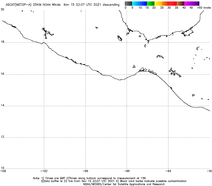
Heavy rains continue to fall in Southeast Mexico due to a tropical disturbance in the Southern Gulf of Mexico's Bay of Campeche, Invest 90L. Satellite loops show that 90L has a well-defined surface circulation, but limited heavy thunderstorm activity. High wind shear of 30 knots, due to strong upper-level winds out of the west, is keeping all of 90L's heavy thunderstorms confined to the east side of the center. An ASCAT pass from last night showed 90L's strongest surface winds were near 35 mph, on the northeast side of the storm. Radar out of Alvarado, Mexico shows little in the way of well-organized low level spiral bands. Sea surface temperatures (SSTs) in the Southern Gulf of Mexico are about 28°, which is about 0.5° above average. These warm waters do not extend to great depth, and the total heat energy available to intensify a potential storm is rather low. The Hurricane Hunters have been given the order to investigate 90L on Friday afternoon at 3pm EDT.

Figure 1. Latest satellite image of Invest 90L over the Gulf of Mexico.
Forecast for 90L
90L appears to be drifting slowly to the west, and both the GFS and European model predict this motion will continue Friday and Saturday, bringing the storm ashore along the Mexican coast near Veracruz on Saturday. The 8 am EDT Friday run of the SHIPS model predicts that wind shear will stay high, 25 - 35 knots, over the Bay of Campeche through Sunday. None of the reliable genesis forecast models predict that 90L will develop into a tropical storm over the next five days. In their 8 am EDT Friday Tropical Weather Outlook, NHC gave 2-day and 5-day odds of development of 50%. If 90L does develop, the strongest it would likely get is 45 mph sustained winds. The big threat from 90L is heavy rains, which will continue over Southeast Mexico into the weekend, causing flash flooding and dangerous mudslides.

Figure 2. Total precipitation recorded for the 24 hours ending at 8 am Thursday June 5, 2014. Rainfall amounts in the 24 hours ending at 8 am Thursday were as high as 8.78" (223 mm) at Palizada at the base of Mexico's Yucatan Peninsula. Thus far, there are no reports of deaths or heavy damage in Mexico from 90L or Tropical Storm Boris. Image credit: Conagua.
I'll have a new post on Saturday at the latest.
Jeff Masters
Figure 1. Latest satellite image of Invest 90L over the Gulf of Mexico.
Forecast for 90L
90L appears to be drifting slowly to the west, and both the GFS and European model predict this motion will continue Friday and Saturday, bringing the storm ashore along the Mexican coast near Veracruz on Saturday. The 8 am EDT Friday run of the SHIPS model predicts that wind shear will stay high, 25 - 35 knots, over the Bay of Campeche through Sunday. None of the reliable genesis forecast models predict that 90L will develop into a tropical storm over the next five days. In their 8 am EDT Friday Tropical Weather Outlook, NHC gave 2-day and 5-day odds of development of 50%. If 90L does develop, the strongest it would likely get is 45 mph sustained winds. The big threat from 90L is heavy rains, which will continue over Southeast Mexico into the weekend, causing flash flooding and dangerous mudslides.
Figure 2. Total precipitation recorded for the 24 hours ending at 8 am Thursday June 5, 2014. Rainfall amounts in the 24 hours ending at 8 am Thursday were as high as 8.78" (223 mm) at Palizada at the base of Mexico's Yucatan Peninsula. Thus far, there are no reports of deaths or heavy damage in Mexico from 90L or Tropical Storm Boris. Image credit: Conagua.
I'll have a new post on Saturday at the latest.
Jeff Masters
The views of the author are his/her own and do not necessarily represent the position of The Weather Company or its parent, IBM.